Good Monday, everybody. We are getting closer to the launch of the brand new Kentucky Weather Center and I know you guys are stoked. 🙂 I don’t have a date just yet, but I’ll let ya know when I know. In terms of the actual weather, we are tracking an increase in storms and the potential for a significant weekend cold front.
Let’s start this party with a look at where we stand on the rainfall front. The latest soil moisture map shows our region in pretty good shape…
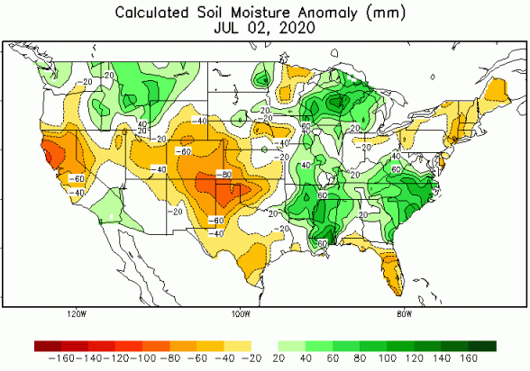 The northern part of the state is a little closer to normal for soil moisture with the rest of the state showing up in a lot of green. Why is that? Look at the rainfall anomalies on the year…
 Some areas of the state are pushing 20″ above normal since January 1st. This seems to be a yearly thing now across Kentucky. That said, if we don’t get 10″ of rain each week, the pathetic Drought Monitor will show us becoming the next Dust Bowl. 🙂
As far as the current weather goes, temps are back into the upper 80s and low 90s as a few storms go up. This isn’t terribly widespread, but any storm that’s out there can put down a lot of water in a short amount of time.A few of the storms may even be strong or severe. Here are your trackers…


The threat for scattered showers and storms will continue with us for the rest of the week. Any storm that goes up can be strong and put down enough rain to cause local high water issues. Again, it’s cloudburst season around here.
We continue to watch the southeast coast for the possibility of a tropical system…

This may hug the coast as it strengthens in the coming days. At the same time, a couple of systems dive in behind this, bringing showers and storms into our weekend…
EURO
 CANADIAN
 This is a very nice trough digging in behind this for the weekend and early next week…
 Have a happy Monday and take care.

I get what you’re saying Chris about the soil map and in my part of Kentucky we are in fairly good shape right now I do farm for a living and rainfall is very important but yes the drought monitor is what I look at because the rainfall that I received 3 or 4 months ago is not near as important as now it’s all about timing when you live and die by the weather
Thanks Chris, Yesterday evening we had one of those Summertime cloudburst that brought very heavy rain with lightning and thunder. The storm lasted about an hour and a half. On the Kentucky Mesonet this morning showed zero rainfall for my county of Taylor, so it was an isolated event. It has been a great growing season so far at lease here in central Kentucky with adequate soil moisture for crops. Looking forward to the brand new Kentucky Weather Center ! Have a great day everyone.
We love Kyweathercenter in our house !
Will the new website also come with you having a better understanding of hydrology? Seriously, you constantly bash the drought monitor map, but why I don’t know? The current DM map isn’t showing any parts of KY in a drought, as we are currently in good shape. Maybe a localized location is abnormally dry due to below normal rainfall over the 5-6 weeks, but that happens pretty much every summer.
Things can dry out quickly in summer. Every meteorologist should know that. If it rains 20 inches in January, that means nothing 6 months later if it hasn’t rained much. I always point to 1999 as a great example. The first half of that year was pretty wet, then come July the facet rain dry. 3 months later after no rain and brutally hot temps, KY was in the midst of one of the greatest short-term droughts in it’s history. Quite a few healthy trees died as a result of that short-term drought. Drought doesn’t have to be a long-term thing to be destructive. Just ask any farmer or agricultural expert. Leave hydrology to hydrologists. These are the experts, not day to day forecast TV meteorologists.
Chris, we know you don’t like trolls on your site. But sometimes you troll your own site, too. It’s a bit unprofessional.
You are one more rude comment from being banned. Your only purpose here is to antagonize me.
It goes both ways, Chris. I actually enjoy your blog because of the model data / analysis you post, but at times you like to throw in non-factual comments in your posts meant to antagonize your readers, which in turn makes you look like a troll yourself. Thus you only open yourself up to criticism. That not only goes for products like the drought monitor you unjustly love to bash, but your regular bashing of the NWS when they don’t issue watches when you feel they are necessary. Apparently you can dish it out, but you can’t take it, so ban away.
Although, there is a professional or a non confrontational way to go about having a disagreement.
Chris is covering roughly 100,000 sq miles as a forecast area day to day, just in Central KY. The weather is fickle. My county(Scott) is under a flood advisory, the second one is a week. I’ve had maybe 10 minutes of rain in a week(including today). My sister in law is 1.6 miles east of me, and she’s not had a drop of rain today. Chris’s criticism of the NWS is often warrented. An F3 tornado was on thr ground in Lexington and a warning wasn’t issued until law enforcement called them. The Louisville NWS office never seems to issue warnings for this area until after the damage reports hit for some reason. As for the drought monitor-it’s taking average rainfalls over certain areas. Again, I don’t expect my area to be considered drought as those around me have been hit. Pockets of dry exits, just like pockets of 20+ above normal. This is a personal blog giving one person’s thoughts and opinions. If you disagree as I do at times, be civil in doing so.
Mark is nothing more than a liar making false statements.
That little break in the heat ( if you can even call it that, still will be hot) will be less humid and about 5 degrees cooler for a day maybe day a half. The life span that weekend front will have on our weather will be too short to remember the minute you blink your eye it’ll be gone. After that it is game on the real deal heat wave looks to arrive.
We are overdue for a “real deal” heat wave and drought. Also, a “real deal” cold and snowy Fall and Winter. I’ll take the latter. lol
Can’t wait for the new website!
Some parts of Lexington haven’t received more than a tenth of an inch for the day in almost two weeks. That’s not drought level, but it is unusually dry. I’ve seen for the past week and change storms go over the same parts of the state.
I personally haven’t seen a thunderstorm in almost two weeks.