Good Thursday, everybody. It’s another day with steam and storms, but changes are on the way for the weekend. That’s when two cold fronts are set to work into the region, bringing an increase in storms and a decrease in temps. That decrease in temps won’t last very long as a plains heat wave threatens to expand our way next week.
Today is back into the upper 80s to low 90s for most of the state. High humidity levels will make it feel like the mid and upper 90s at times. That same high humidity will help crank thunderstorms that can put down a ton of rain in a small time span. These storms may also briefly go severe with damaging winds the main threat.
Here are your tracking tools for the day…


Before we get to the weekend systems, let’s talk about the system off the east coast. This continues to become tropical as it hugs the coast all the way to New England…


That system will ride northward along the east coast through the weekend and could have a decent impact all the way into southern New England…

Two fronts dive in behind this system to impact our weather from Friday through the weekend. The first front arrives Friday with showers and storms on the increase. Strong storms and heavy rains will once again be possible. Temps and humidity levels come down behind this for Saturday and it feels pretty good. Our Saturday sky may look pretty darn nice, too.
A potent system drops in here Sunday with booming thunderstorms a good bet. Here’s a look at both systems…

Temps are generally in the low and middle 80s into early next week. Make sure to enjoy that because the hottest air of the summer may very well move in here later next week…
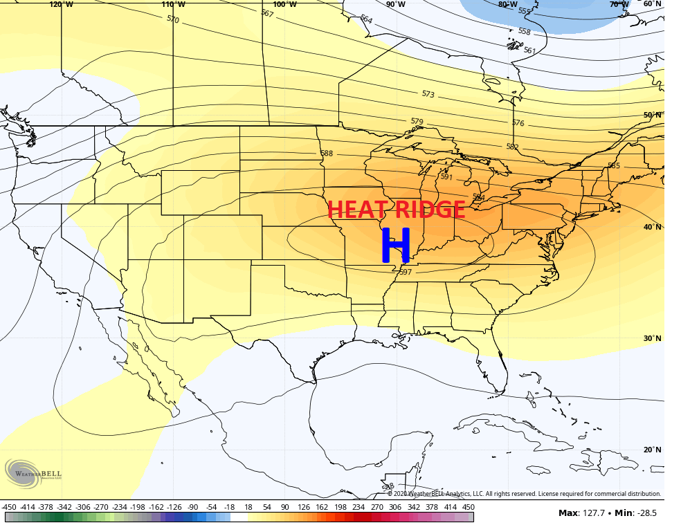
If you recall back in early May, the main analog to the late season record cold was 1966. That gave Lexington the coldest May temp ever recorded while this May gave us the second coldest May temp ever recorded. 1966 went on to feature a period of real deal heat (mid-upper 90s) in July, before below normal temps ensued from August through the winter. As a matter of fact, August 1966 couldn’t even get to 90 in Lexington. Interesting.
Have a great Thursday and take care.

All I can remember in early November 1966 we had 10 inches of snow where I grew up in south central Indiana. While the snow was falling I was watching it in amazement while I was in my Algebra cla*s*s. The rest of the Winter turned out uneventful (1967) as far as snowstorms go. February was cold and dry. The snowiest Winter was 1969-70 from what I can remember.
The coolest August I can remember was in 1964, again in south central Indiana. The temperature lows were in the 40’s and highs someday’s that month were in the upper 50’s. Everyone was wearing sweaters and jackets. I remember scientists said the unseasonably cool August weather was due to a Volcanic activity.
Every day my part of northwest Lexington has gotten missed by any rain. Well, not today! My house is currently being power washed