Good Friday, friends and neighbors. The Dog Days of Summer are upon us and it’s certainly feeling and looking the part. We are pretty much locked into a super steamy setup that will give us daily rounds of showers and storms through next week. No, it’s not raining at your house each and every day. 🙂
Let’s start things out by saying the brand new Kentucky Weather Center is scheduled to launch next week. I’m not sure about the exact date, but it is just about go time. This will have several new features, including a message board for you guys. You will be able to offer up your own weather maps and goodies and just start discussions about anything dealing with weather. The new site will require you to register, but it’s still free of charge. 🙂
In terms of the weather going on out there today, it’s a very tropical air mass settling into the Commonwealth. Highs will be all over the place because of clouds and a few storms. Temps will top out anywhere from the middle 80s to low 90s, depending on where the storms hang out. Regardless, humidity levels will be sky high.
The best chance for heavy rain producing storms is across the southern half of Kentucky through this evening. Remember, it’s cloud burst season around here and that means we always have to be on guard for local flash flooding. Here are your tracking toys for the day…


This pattern is locked and loaded through next week…

Since we are now past the halfway point of summer, it’s time to start thinking about the fall and winter ahead. The first thing we have to do is check on the equatorial Pacific to see how things are shaping up. We are coming out of a weak El Nino and it appears we are entering into a weak La Nina for the months ahead…
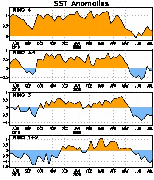
You can see the cooling waters in the region I’ve highlighted. I’ve also circled a pool of very warm water in the northern Pacific near the Gulf of Alaska…
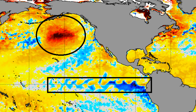
It will be interesting going forward to see if that pool maintains itself and whether it can move a little farther north and east.
There aren’t too many analogs of where we go from a weak El Nino to a weak La Nina. 1995 is the only one that truly fits since 1950. 2005 is in the ballpark, but the La Nina came on much later. Both of those were busy hurricane seasons, with 2005 being the top dog of all-time. Both years did bring fall hurricane rains into Kentucky.
Make it a good one and take care.

Thanks Chris, Yesterday we had a heat index of 106 degrees and then yesterday afternoon the rain showers started in and lasted until Sunset. Very uncomfortable this morning here in central Kentucky, but I’m going for a walk anyway.
Glad the new format of the Kentucky Weather Center is about to become reality. I just hope I can keep up as I am not to computer literate. I may have to leave it to the younger folks.
Here is a list of El Nino and La Nina Years and their Intensities. I remember our snowiest Winters occurred in the years where we had a weak El Nino such as 1969-70 and 1976-77 to 1977-78. We must take in consideration that it is just a watch for a weak La Nina and not yet carved in stone. https://ggweather.com/enso/oni.htm
Shaping up to be an active hurricane season according to the pro’s beginning August..Hope there wrong.
Maybe the hurricanes will stay away from the mainland.
Sweat season is upon us.
The entire state of Illinois is under a Heat Advisory for Saturday, including the Chicago Metro area, with heat indexes predicted to exceed 105 degrees. It’s the first Heat Advisory for the summer here, even though we have had numerous 90-degree days.
That may lead to a major severe weather outbreak here late Saturday night into early Sunday, with a strong cluster of storms moving through that could bring damaging winds and torrential rain.
Certainly something to keep an eye on this weekend.
Mike, It’s been raining and thundering most of the day and to add insult to injury we had a two hour power failure. The rain train is running right over my home. LOL