Good Wednesday, everyone. It’s a very wet pattern taking shape across Kentucky and surrounding areas over the next few days. Rounds of showers and thunderstorms are ready to rumble across the region, bringing a high water threat and much cooler temps through early August.
Let’s begin with today’s weather and roll forward. We continue to see a scattering of showers and storms across the southern half of the state. A few may be strong and put down heavy rains. Farther north, things are better in terms of the sky with seasonal summer temps.
Here are your tracking tools for the day…


We are tracking multiple systems in the coming days. The first arrives late tonight and goes through early Friday and may dump a general 1″-3″ of rain for many, with locally higher amounts. Another system then follows that up later Friday into the start of the weekend.
I made this map several days ago and it looks to be in pretty good shape…

I will get more specific on that later today. Local flooding and flash flooding is certainly possible during this time.
You can see both of these systems and a third showing up by Monday…
 Temps will be average much cooler than normal, especially afternoon highs under the clouds and rain.
Our tropical system heading into the Caribbean continues to churn away and should reach Florida over the weekend…

The ultimate path of this system will, obviously, have an impact on the weather across the eastern half of the country.
Some models take this across Florida and into the Gulf, then skirting by just to our east. That’s what the EURO shows…
 The GFS takes brings this more toward our region and merges it with a slow-moving upper level low…
 The Canadian is the most in tact with this system and zips it just to our east, with deep trough diving in behind it…
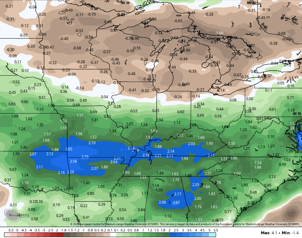
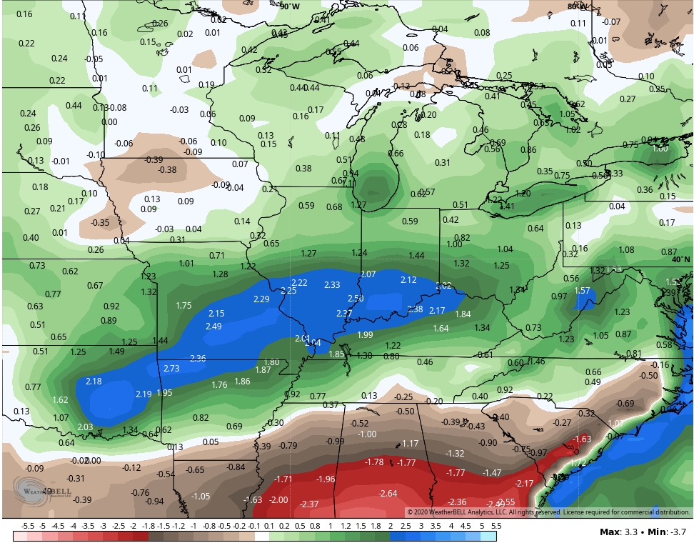
 Regardless, this is a very busy setup as we roll into the first week or two of August. One that looks to feature widespread above normal precipitation. Here are the anomalies from the Ensembles…
EURO
GFS
I will be back on WKYT-TV starting at 4pm, but will also throw you guys another update at some point, so keep checking back.
Have a wonderful Wednesday and take care.

It’s a very foggy morning here in central Kentucky with a temperature of 70 degrees. Yesterday, early morning we had an unexpected “down pour.” Estimated rainfall total of about 0.40 inches. I like the up coming cooler temperatures, but not the bouts of rain and clouds and high dew point temperatures ugh! It could be just the opposite with 100 plus degree temperatures and “blistering” Sun. No happy medium LOL.
The tropical Storm path goes right over the area of Florida where my Sister and brother in law live. I have a Zoom meeting with them on Friday. Hopefully, we will know more about the path by then ?
One last day to mow the lawn before the Monsoon heads to our region.
We mowed the grass/weeds around our cabin late Saturday afternoon. You can’t mow in the morning or at noon because you have to wait till the grass dries out, the dew is so heavy almost every morning here. As a result the yard work around the home continues to pile up. A cycle that doesn’t break until it freezes. Autumn can’t come soon enough for me. LOL
We mowed our lawn late Saturday afternoon and then 24 hours later the skies opened up. Needs to be mowed again if we get a break in these showers. I just might let it grow and let the frost get it. It’s just weeds anyway. LOL