Good Wednesday afternoon everyone. The risk for flooding continues for Thursday into Friday across the entire state. For that reason A Flash Flood Watch and Flood Watch is now out for almost the entire state of Kentucky.
Here is a look…
I am not a big fan of leaving a few counties here or there out of the watch… but I don’t issue them. When dealing with a situation like we will be seeing for this storm… blanket the entire state with the watch and be done with it.
I have no changes in the expected rain forecast…
Flash flooding and river flooding will be possible with this event so if you live in a flood prone area… please be alert to the potential of high water.
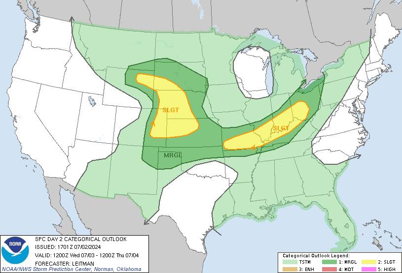
In addition to the flooding threat… parts of western Kentucky have the potential for some severe thunderstorms. While the greatest threat will be south of the state… the Storm Prediction Center has a slight risk out for part of the state…
Showers are already breaking out across the western part of the state and this is the beginning of the active few days ahead of us. Follow the rains here…
I will update as needed so check back. Have a great rest of your day and take care.
Select Page
Well, hopefully we will not have any risk for the Tornies in E-Town, I can handle the flooding if I have to (I have a huge blow up raft, lol!) but Tornies are not my favorite 😉
Thanks chris. Anyone seeing a possible repeat of may 2010 with back to back huge storm systems Thurs and sun?
I told ya’ they’d pull the Slight Risk for severe storms out of central KY today.
Rainfall, on the other hand, is a different story.
http://www.hpc.ncep.noaa.gov/qpf/94ewbg.gif
Thanks Chris!! I agree with you. The more people that are informed, the more the world will spread for preparedness!
Don’t cross any roads covered with water!! Your life is precious!!!
I’ve got some photos from the E-town flood of a couple years ago. It was BAD down there. Cars just swept away right there in neighborhoods. Craziness.
I’m on the muskingum river just north of the Ohio. Both rivers already swollen, this much rain could cause a major flood for the marietta ohio area, especially if they also get it up river, which seems likely. I hate to see it coming! Thanks for keeping us prepared Chris!
Hope everyone boarded up their homes, the hurricane is coming!!! lol
Time to get “ARK” outta storage!!!!We get that much rain in that short of a span down here it will big trouble for the Cumberland River
If anything, the latest NAM18z appears to take the main system a tad north. May be strengthening. Heavy rain still likely. Now, where does the heaviest part set up? Looks to shift a smidge north.
I hope everyone is prepared for flooding, because there could be a lot of it in the next week. I have an update over on my blog too if any is interested.
when is the rain supposed to start?
Gee.
Thanks.
Any info on what areas in E-Town? I’d kinda like to protect my kiddos since we live on the opposite end of town from the school. Area around school is flat and we live on top of a hill.
Winter Storm watches out for northern parts of central Indiana! News is saying that areas north of Indy could see 1-2″ an hour! With totals of 4-7″! But I live a bit south of I-70, but still sounds interesting!
And everyone’s saying “at least it’s not snow!” (not here, but everywhere else)… um, I’d take snow over flooding rains ANY DAY!
Have no Faith in what the models say.Snow after snow after snow missed us this winter when we were in the Bullseye and will guarantee Ky gets no more than inch and a half of rain.Storm is going north…
Which is precisely why this one will probably smack us head on. No snow here so no reason for it to miss us >:/
So why is the excessive rainfall (HPS) risk of moderate in western KY only 10 to 15 percent…….??…….I mean, wouldn’t moderate be considered at least 40 percent?
I live in glendale, which is just south of Etown. I know the area pretty well. Do you live i nthe north end of town or the southern end. It seems like it floods more in the western and southern ends of town.
I’m not sure about that either. Though, I really do not know how they calculate their stuff. I guess it is done automagically! Anyway, I suppose their percentages would be higher if the ensemble guidance still did not have all that spread in their solutions.
where is that “like” button?
Thanks, Chris. I agree. the whole state should have probably been included in the watch area. I have seen flash flooding take place on the dealership lot that I work for. when it comes down that heavy, it simply has no place to go, and with the ground already being soggy, it could really get ugly in a hurry.
Please, everyone, stay up to date on current conditions, and remember to avoid water on the road. Thanks again, Chris, for the heads up. I know you will keep us posted.