Good afternoon, folks. One complex of thunderstorms is slowly working out of the area, but additional rounds of storms roll in through early Tuesday. Some of these storms may be strong or severe and put down a ton of rain.
The Storm Prediction Center continues to put the region in the severe weather risk…

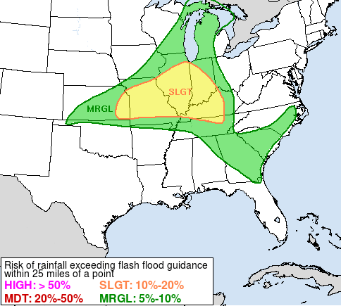
We are likely to see a couple of big storm complexes dropping in here from the northwest this evening into early Tuesday. Damaging wind is the primary threat from these storms as they race through. The storms also be big time rain producers and may cause flash flooding issues for some. The WPC has much of the region outlined for this possibility…
Here are your tracking tools for the rest of the day…


Current watches

Possible Watch Areas

Make it a good one and take care.

Tornado warnings out for my area… skies are getting extremely dark with thunder and lightning… I’m taking cover and will check in later.
Please do check in when you can. Good luck with that weather up there!
Mike,
Be safe brother…
Everyone take care as well
That derecho is not wasting any time, already near the northeast Indiana/northwest Ohio line. Hopefully little more than widespread power loss, but winds that strong are concerning…
The watch that covered areas like Milwaukee and Chicago was a PDS Severe Thunderstorm Watch (Particularly Dangerous Situation). PDS Tornado Watches are unusual enough, PDS Severe Thunderstorm Watches are even more rare.