Good Wednesday, everybody. Tropical skies are back with us today and we are seeing rounds of showers and storms pick back up. This happens as a wave of low pressure develops along a stationary front on top of the region, bringing the potential for some very heavy rains. As we look into next week, it’s another big shot of cooler than normal air taking aim at our area.
A few storms roll back into Kentucky today from the southwest. This action will increase tonight and take us into Thursday and Friday when some downpours will be likely. This slow-moving system may take us into part of Saturday. The NAM is showing some of the hefty totals through Friday night…
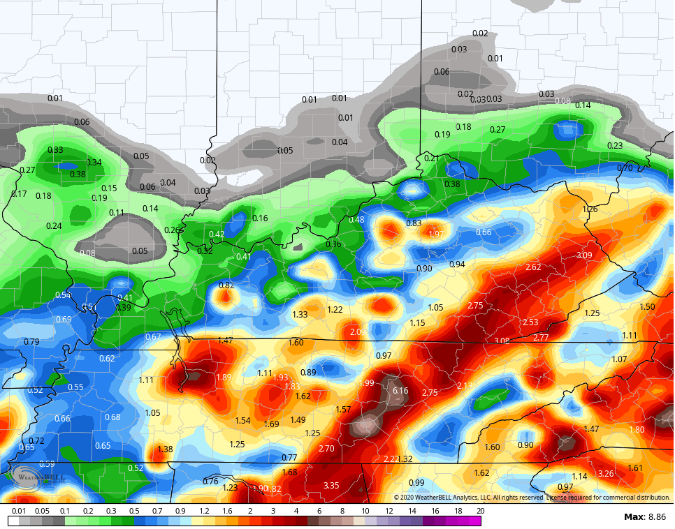
Those slow-moving lows can sometimes overachieve and put down enough rain to cause some issues. We need to keep a close eye on that threat in the coming days.
By later Sunday and Monday, a strong cold front drops in here from the northwest and brings another big blast of below normal temps next week…
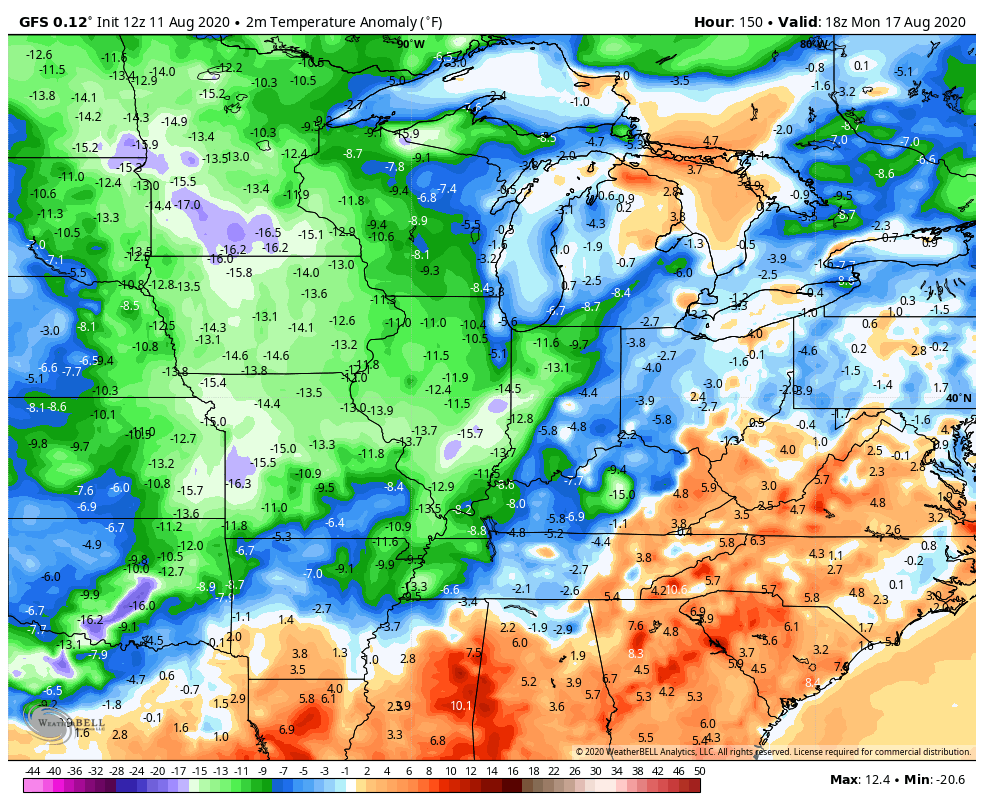 How low can we go? A few of the recent model runs have had temps nearing 50 for lows, but we would have to have clear skies for that to happen. I do think we can get a few days, at least, of highs in the 70s. One thing to watch is the potential for an upper level low to spin up near us. That could keep a few showers going if it happens.
The tropics can also play a big role in the overall pattern and we have a developing system in the Atlantic…

I leave you with your tracking toys for the day…

Make it a great day and take care.

Sounds alright to me.
Thanks Chris, I can take the “steam and storms” in advance of the beautiful early Fall like weather forecast for next week, even if it just last about three days.
Watching the tropics for development.
I know I will be taking advantage of those 3 days.
Looking forward to some cooler Fall days
Do you have a time frame for when the rain may ease up Friday night into Saturday??? Thanks for all you do!!!
Sounds great
This is the first chance I’ve had to check in since the intense severe weather we had Monday afternoon. The power was out in my area for an incredible 32 1/2 hours, from 3:45 PM Monday to 12:15 AM Wednesday morning! Fortunately, on my block, there was no major damage except for all kinds of small tree limbs and branches being ripped off trees. Around my town though, many large trees or parts of trees were blown down, including a tree that fell into a bank of power lines just a couple of blocks from me. There are still tens of thousands of people without power in the Chicago Metro area.
In an amazing coincidence, August 28th will be the 30th anniversary of the devastating F5 Plainfield/Crest Hill tornado, which was the strongest tornado to ever hit the United States in the month of August. The storms that we had Monday came through at the exact same time, 3:35 PM, as the tornado 30 years ago!
Here is a complete summary of Monday’s severe weather from the Chicago NWS: http://weather.gov/lot/2020aug10
The power and strength of Mother Nature continues to amaze me!
There were seven confirmed tornadoes in the NWS Chicago county warning area, including the strongest tornado to hit the city of Chicago since 1983!
Ir’s a gorgeous day today here, with sunny skies, temps in the low 80s and low humidity. There is very little if any rain predicted here for the next week, so cleanup efforts across the area should go well.
Thanks Mike, Glad your Okay! I’ve learned more about Derechos over the last few days. Read in the link you provided that a waterspout formed over Lake Michigan, amazing !