Good afternoon, folks. It’s an absolutely gorgeous day across the Commonwealth and this September feel carries us through the week into the weekend. The focus of this update is to share a seasonal model for the upcoming winter.
I will get to that in a moment, but let me offer up a few words on the current setup.
We know the temps are marvelous today into Thursday. There’s an isolated shower or storm that will try to get into the south and southeast through this evening. That action comes a little farther north into Thursday, but the main action arrives Friday and Saturday.
Both of those days will see much better coverage of showers and storms. If you’re making outdoor plans, keep that in mind.
The pattern after that depends on what happens with the tropics and we have a lot of action beginning…

Notice those systems are abiding by 2020 rules and are practicing social distancing from one another. 🙂 I’ll be here all week!
We are into the time of year where I like to really begin compiling data for the winter ahead. At first glance, this doesn’t appear to be as complicated as in prior years, but I’m not sure if that’s good or bad just yet.
It’s also when we can start to look at what seasonal forecast models are saying. There are many seasonal models and they all change from run to run, but can offer some clues. I also like to see which seasonal model is performing better than the others. For my taste of late, the CFS has been doing a fairly good job for a seasonal model. It nailed this cooler than normal August, while other models were showing blazing heat.
Again, I have to start by telling you seasonal models should always be taken with a grain of salt. I feel like you guys have been here long enough to understand that, but the folks who are no more than twitter trolls still living in their parents basement can’t seem to figure this out. I digress.
If we look at the 500mb charts from the CFS, it’s showing a good pattern for winter lovers in our region.
DECEMBER
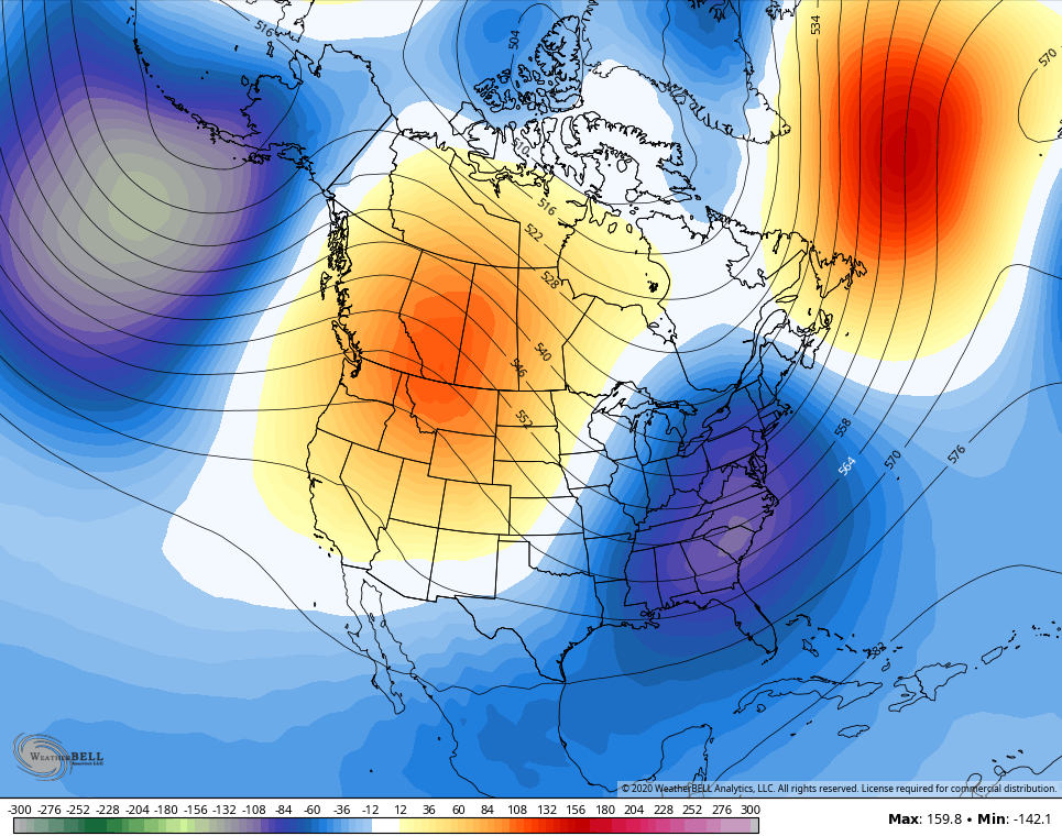
JANUARY

FEBRUARY

MARCH

As I mentioned, that will change from run to run, but it’s an interesting look nonetheless. I’m going to be showing the European Seasonal Model here in the next week or so, but the entire suite of European Model family has some serious issues anymore. The model family has a MAJOR heat bias and simply cannot see any kind of cooler than normal temps anywhere. Had the operational Euro been correct, we would be coming out of one of the hottest summers on record here in Kentucky. There were several occasions the model was showing temps of 100-105 around here. Remember the social media frenzy of those 7-10 day forecast high temp maps? Funny how the same people who complain about sharing a model forecast for snow are the first ones to share a model forecast of 105 degrees from 10 days out. Maybe a few folks have an agenda?
I feel like I should end this by saying… GET OFF MY LAWN! 🙂
Enjoy the day and take care.

Thanks Chris, At lease it gives us Winter Lovers hope. Maybe a snowy Christmas and New Years Eve like we had in 1969-70 ?
More recently, Christmas 2010 was snowy….or at least had a white Christmas. Schroeder, I at the time was living/working in Evansville IN which of course was your old stomping grounds. But I was able to arrive in the Chattanooga/Cleveland TN area (where my folks live) before the snow started. Bowling Green, Nashville, Huntsville, even as far south as Auburn AL had an “official” (at least one inch of snow) white Christmas in 2010.
I can take some snow during the holidays (no ice though), but I’m otherwise a warm weather person. As some of you know, my better half (wife) loves winter. But Nashville TN has not had a “real” snow since the big January 2016 event so she’s more than read for a nice dumping 😉 .
While I was living in Evansville, Indiana (37 years) I can only remember one White Christmas and that was in 2004. Up to 2 feet of snow fell on the 23rd of December at Dress Regional Airport.
In 2010 we had 2 inches of snow on Christmas Day here where I live at the present.