Good Thursday, everybody. It’s another very nice feeling weather day across the state, but the threat for showers and storms will be on the increase in the coming days. This happens as humidity levels begin to come back up and the overall pattern turns more active, especially in the tropics.
Let us kick things off with what’s happening out there today. Temps are likely deep into the 50s for many to start out and recover into the upper 70s and low 80s. Humidity levels are still into the comfy category, so enjoy.
There is the threat for a few showers and storms going up across the south and southeast, but that may try to inch a bit farther north as the day transitions into the night. Here are your tracking toys for the day…

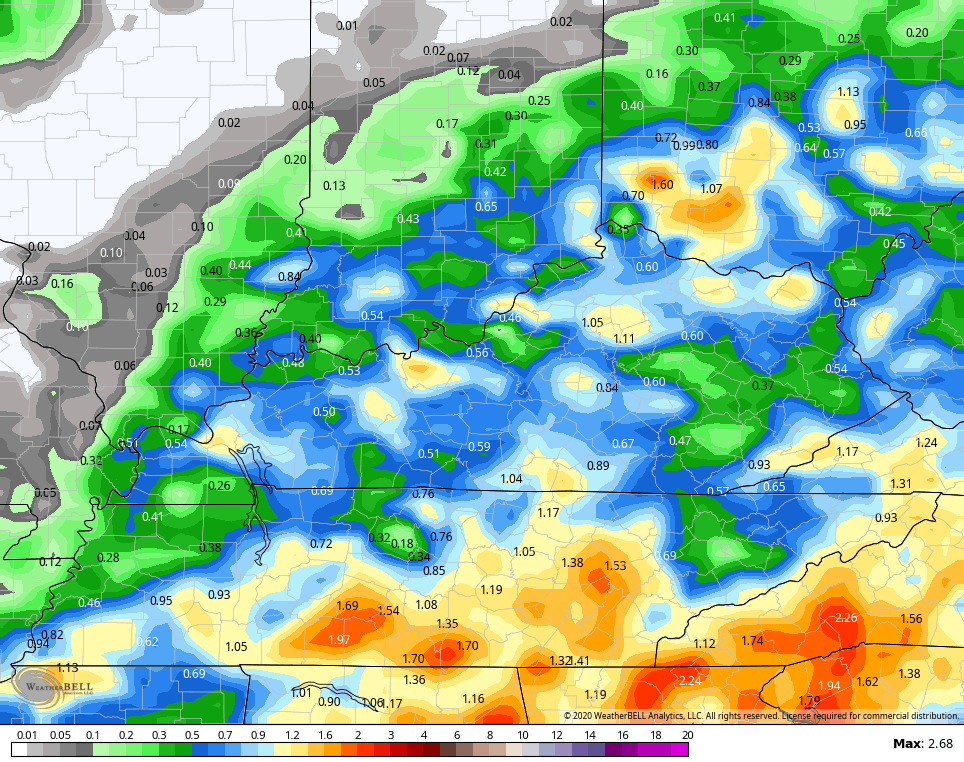
As moisture increases Friday through Sunday, showers and storms become more common. The setup is not producing rain all the time, but we are likely to see some heavier downpours show up. Here are the totals from the GFS through the weekend…
The tropics continue to spring to life with three systems on the move…

Tropical Depression 13 looks like the main one to watch and this should head toward Florida over the weekend and early next week and may even get into the Gulf. Here’s the current forecast from the National Hurricane Center…

The latest operational models continue to, as expected, vary greatly on the evolution of 13..
GFS
 CANADIAN
 I will have another update later today, so check back. Make it a good one and take care.

As I was taking the trash down to the end of my driveway this morning I notice that “muggy feeling” to the air. Looks like we are going back to our more typical Summer weather, which hasn’t been that bad except for the frequent showers.
I read this morning that the Bermuda High Pressure System in the Atlantic is moving west towards our southeast region. If any tropical storm forms it very well could impact Florida because these storms like all storms follow the western edge of high pressure.
I’m hoping the “vertical wind shear” will take play and destroy the storms before they become hurricanes as this country does not need anymore “natural disasters.” anywhere.
Our string of dry, pleasantly warm weather continues here in the Chicago area. It’s sunny this afternoon, with temps in the low 80s and dew points only in the upper 50s.
Not a drop of rain is in the forecast here through at least next Wednesday, with gradually warming temperatures. In fact, a late-season heat wave is on the way for next week, with temps in the 90s predicted for Monday through Wednesday.
Mike, We are having a nice Sunny day here in central Kentucky with a high of 81 degrees and a dew point in the upper 60’s. The Gulf is opening up once again and Kentucky will have the same kind of weather as southern Florida by Saturday.