Good Monday, everybody. The full focus of the forecast is on the two tropical systems down in the Gulf of Mexico. Marco is moving ashore today, with Laura expected to make landfall by Wednesday. The first won’t impact the weather here in Kentucky, but Laura looks likely to bring a big impact our way by the end of the week and into the coming weekend.
A tropical feel is with us to begin the week and this will lead to a few more storms out there today. This action looks fairly scattered…

The humidity REALLY ramps up over the next few days and it’s going to feel pretty darn tropical. That comes with mainly dry weather, but some moisture ahead of Laura may slide in here as early as Wednesday night and Thursday.
Ok, let’s get started on this historic setup in the Gulf and how it affects Kentucky.
Marco is rolling toward the Louisiana coast today and should make landfall later this afternoon or evening. This storm is trying to fall apart right in front of our eyes. Here’s the latest from the National Hurricane Center…

This system may try to weaken before coming ashore then weaken pretty quickly as it turns west toward Texas. Take our exclusive interactive radar out for a test drive and go right into the heart of the storm. Check out the all the tabs on the left side to see just how much information you can get from this setup. Don’t forget to look for the live streams from storm chasers in the path of Marco…
I pay a lot of money for that radar so you guys don’t have to! 🙂
Laura is fighting with Cuba, but will emerge into the Gulf on Tuesday. It won’t take long to strengthen into a hurricane as it heads toward Louisiana on Wednesday. My initial thoughts bring this right up the Mississippi River then into Kentucky by Friday…
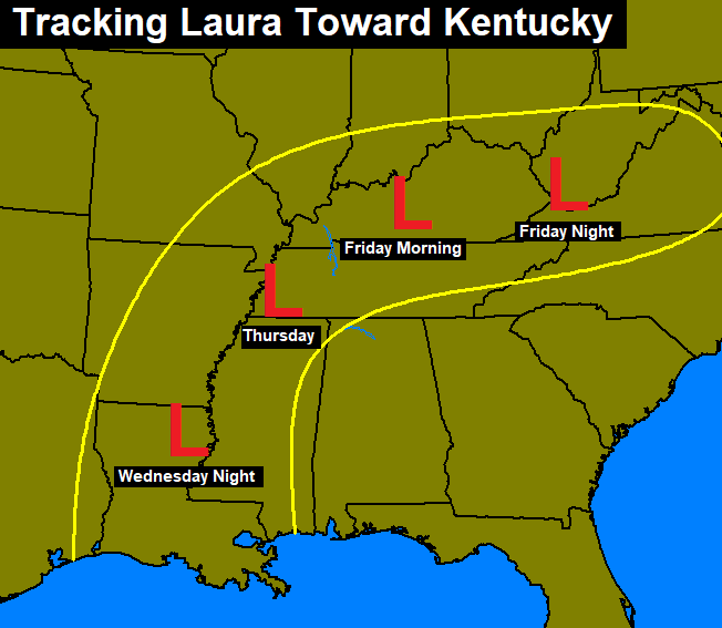
A track like that would result in heavy rainfall, gusty winds and the potential for a few strong storms ahead of the spin. Of course, I will make changes as the setup becomes more clear in the next day or so.
The National Hurricane Center cone of uncertainty now fully extends into Kentucky by Friday…

The Hurricane Models are all aboard the bluegrass train…

Tropical systems rolling into Kentucky have actually become very common over the past 10 years or even past 20 years.
Following this up could be a potent system working in from the northwest with strong storms as we get head into the first few days of September. This would be associated with a couple of deep troughs that bring fall temps in here. I wouldn’t be surprised if some lows hit the 40s at some point in the first week or so of September.
As I’ve been saying, the pattern for September is the polar opposite of last September when heat and a flash drought took control.
I’m off work again today, so that means another update or two will be coming your way here on KWC. Until then, have a good one and take care.

Thanks Chris for the updates and the interactive radar which I feel is a much needed for all of us who like to tract major storms.
Marco was a hurricane for a very short time, but now seems to be weakening rapidly. I’m sure there will be a lot of rain in those areas to the east of the center.
We will have to wait next for Laura to make her appearance in the Gulf. Hopefully she will not become a major concerned for folks along the Gulf coast.
Enjoy your time off Chris. I will look forward to your updates.
Maybe this will be the last week of the year that we have extreme heat.
I had my spinal fusion last Monday so I missed all the nice weather, but I’m back for Marco and Laura. Is it scary that you miss a weather blog when you’re away from it? 🙂