Good Wednesday, everyone. We have another juicy day out there and this is likely to spit out a few rounds of showers and thunderstorms. Some of these storms may be on the strong side and put down very heavy rain. This looks to continue into Thursday and is right ahead of a fall cold front arriving on the scene. This is the first in a series of fall fronts that will take our temps to well below normal levels into next week.
My biggest concern with the storms of today and Thursday continues to be the potential for local flash flooding. The ground is already soggy in several areas, so it won’t take much more to cause some issues. Some hot spots of 1″-3″ of rain will likely show up during this time, so let’s keep that in mind. You can see the various models showing a southwest to northeast corridor of heavy rainfall…
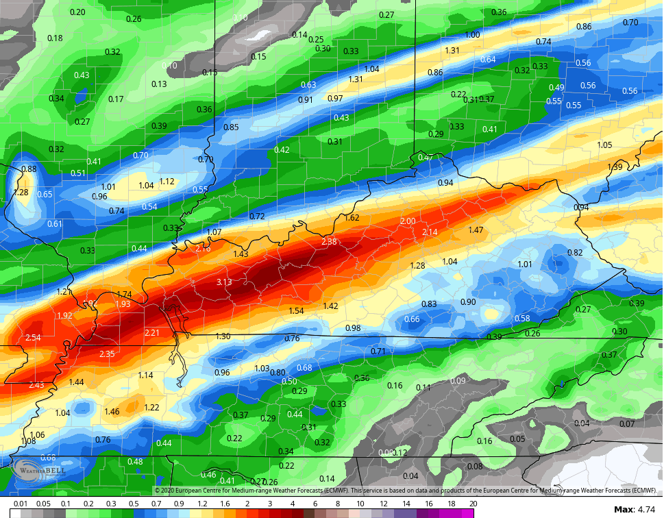
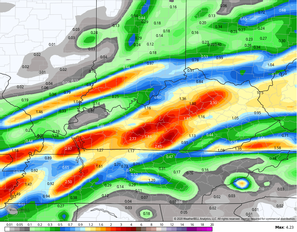
Again, that’s through Thursday and much of that may actually come late tonight and Thursday morning.
A few of today’s storms may also be strong or locally severe. The Storm Prediction Center keeps the low-end risk for severe weather across parts of Kentucky…

Our front rolls through Thursday night and early Friday as showers linger in the south. Much cooler and drier air works in with highs in the 70s for Friday with lows by Saturday morning into the low and middle 50s.
Kentucky Derby Saturday looks amazing with highs mainly in the mid and upper 70s with low humidity and a partly sunny sky. Just wow!
A cold front approaches us by Sunday night into Labor Day with some scattered showers and storms. This is ahead of a MAJOR blast of chilly air into much of the central part of the nation that works in here by the middle and end of the week. This will be accompanied by rounds of showers and storms…

That could slow down even more in the coming days, so we need to watch that setup.
The fall chill associated with this setup is absurd for so early in the season. Look at the temp departures from the GFS…

The average of the GFS Ensembles…
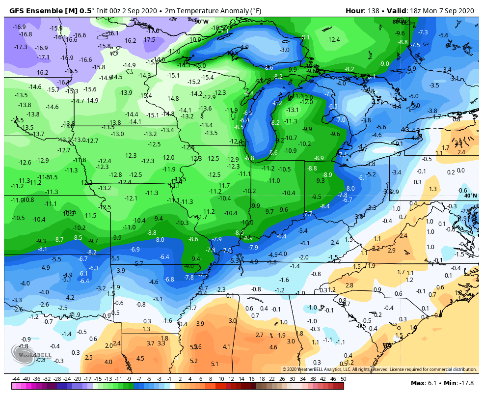
Polar opposite of last September!
I will have another update later today. I leave you with your all important rain and storm tracking tools for the day…

Current watches

Possible Watch Areas

Have a good one and take care.

Thanks Chris, heavy rains this morning training out of Bowling Green right over my area of Taylor county.
We have had 1.88 inches of rain in the last 48 hours in my backyard and more is being added at the present.
Saturday is the best day of this week with lower dew points, but temperatures in my area are not going to be “Fall like” as I expected earlier with highs in the mid 80’s and lows in the upper 50’s.
A major cold front expected late next week, please don’t disappoint us Mother Nature.
“Sick” of the tropical weather we have had this Summer. I didn’t mind the weather we had in September last year because we had our normal dryness, but the night temperatures were too warm for September.
Weather history was made in Chicago for the recently completed meteorological summer, as the average temperature of 76.7 degrees at Chicago’s O’Hare Airport made it the warmest meteorological summer on record! The previous warmest had been the summer of 1955, with an average temp of 76.4 degrees (Midway Airport was the official reporting station then).
This June was the sixth warmest June on record, July the fourth warmest, and August the sixth warmest. August was also the sixth driest August on record, with only 0.80 inches of rain for the month, with many areas receiving less.
It should be noted that the urban heat island of Chicago keeps temperatures there warmer in the summer than in the suburbs or areas further inland, due to the proliferation of concrete and tall buildings. Rockford, which is about 90 miles away from Chicago, had an average temp this summer of 74.7 degrees, which was 2.0 degrees cooler than Chicago, and tied for the sixth warmest summer on record there.
Also, O’Hare Airport is located about nine miles away from Lake Michigan, which limits any cooling effect from the lake when the winds blow from the NE in the summer. The cooling effect of the lake winds is much more noticeable during the cooler months of the year, even here in the SW suburbs where I live, about 40 miles away from the lake.
Here is a complete recap of Chicago’s summer of 2020 and the month of August from the NWS Chicago web site: http://weather.gov/lot/summer2020
Interesting Mike, I haven’t any records to post for my county of Taylor. Can’t find them anywhere on the internet. Population is too small and is decreasing in my county. No one here probably wouldn’t be interested anyway except those who farm for a living.
Lake Michigan is interesting how it modifies climate in northeast Illinois and especially in southwest Michigan in the “snow belt.”
When I was in the nursery business back in the 1960’s-2006, I had business relations with nurseries in southwest Michigan who could grow tender Azaleas and Rhododendrons that would not take a Winter in southwest Indiana.
I thought at one time I would like to live in the “snow belt,” but now I am just too old to move again.
Oh well, here where I live it will snow again someday.