Good Thursday to one and all. Rounds of showers and storms are pushing through the region today and keeping the strong storm and flash flood threat going. This action finally gets out of here as a fall cold front sweeps in here tonight and early Friday. That unleashes a blast of cooler than normal air into the start of the Labor Day/Derby Day weekend. The setup for next week continues to look even cooler as a big storm system heads our way.
Today’s showers and storms will be much more prominent during the first half of the day. This is when high water issues are very possible in some areas, so please keep that in mind. A few storms may also be strong across the east. Here’s today’s Severe Weather Outlook from the Storm Prediction Center…

Our cold front arrives overnight into early Friday and will have a band of gusty showers along and ahead of it. Once it sweeps through, the air turns absolutely awesome from north to south on Friday. Highs are in the 70s as humidity levels tank and that sets the stage for a cool Saturday morning…
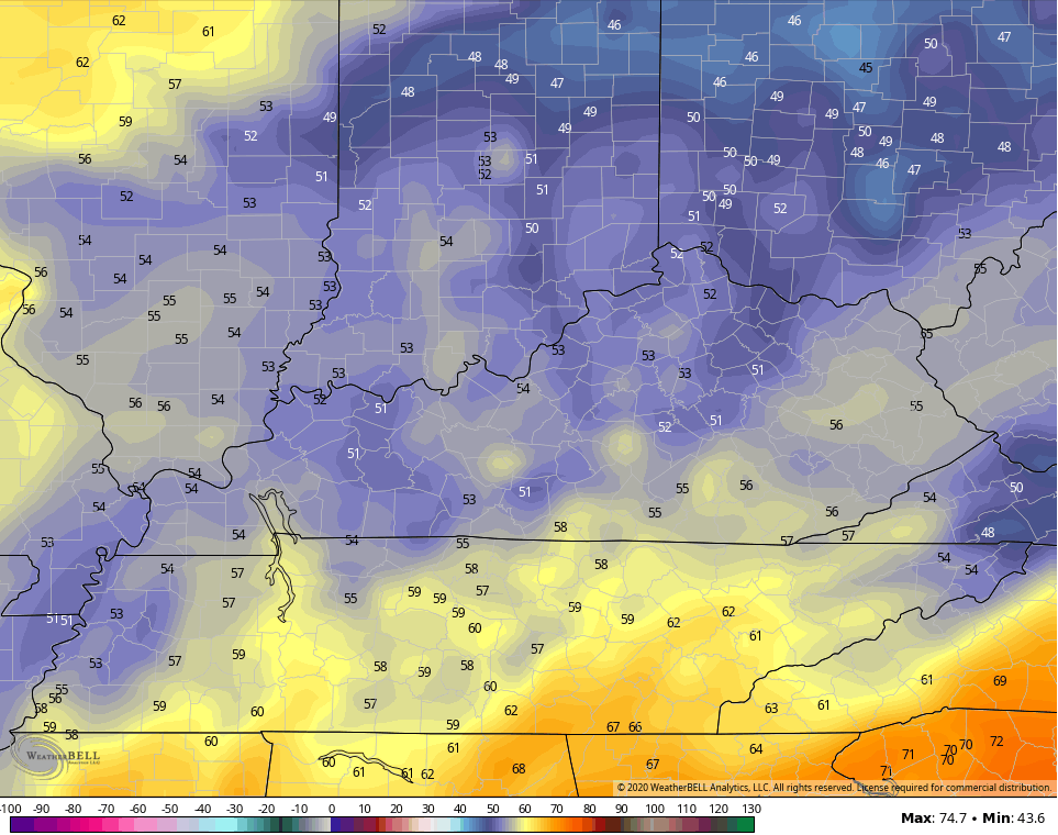
I think the cooler valleys can drop into the upper 40s!
The rest of Saturday keeps the fall feel with highs in the 75-80 degree range with a mix of sun and high clouds. Basically, it’s awesome for Derby Day and Labor Day festivities.
After another morning in the 50s, temps rebound toward the low 80s on Sunday and there is a small shower or storm risk.
The setup for next week continues to evolve and it’s doing so a little slower. The closed low idea looks to have merit as a blast of cold air dives into the middle of the country. Watch how the GFS and Canadian are in lock step with one another…
GFS

CANADIAN

Those are pretty spot on with one another in the upper levels and that translates to good agreement at the surface. Both develop a big low pressure working into the region by Wednesday, bringing rain, storms and gusty winds. That would be followed by some real deal chill…
GFS

CANADIAN

With the slower evolution of this setup, it means your early week temps will be able to spike into the 80s. Once that storm works in, it would bring a dramatic drop in temps for the second half of the week into the following weekend. It’s also a pattern that may bring some big time early season snow to the Rockies!
I will have updates later today, so check back. Until we meet again, here are your tracking tools to keep you company…
I leave you with your tracking tools for the rest of the day…

Current watches

Possible Watch Areas

Make it a great day and take care.

I would think the European Weather model would have to be factored in along with the American Weather model and the Canadian Weather model ?
I like hearing about the first snows in the Central and Northern Rockies.
Looks good for outdoor work, but only on Saturday.
“Fall like cold front” to clear the state of Kentucky at the end of next week into the weekend still looks undecided as to how far east and south it will go ?
What goes on in the Tropics will weigh heavy on the coming Fall and Winter weather here in the Ohio Valley.