Good Sunday, folks. It’s another pretty awesome weather day as gorgeous Labor Day Weekend rolls on. As we look into the week ahead, we find two different storylines. The first half of the week is mainly nice and warm, but the second half of the week features a big fall storm system moving in. This will bring an increase in rain and storms and a massive drop in thermometers.
Let’s get this party started with your Sunday outlook. We start the day deep into the 50s, with an upper 40 possible, and we end it with sun and low 80s for many.
There’s a weak front making a run at the region from the northwest later Monday. This has a shot at bringing a shower or storm to the north, but most miss out.
As all this is going on, some of the wildest weather you will ever see or hear about is going on across the Rockies, especially around the Denver area. Denver hit 101 on Saturday, making it the hottest September day on record there. They will be near 100 again today and may not be too far away on Monday. By Monday evening, a cold front is dropping in with an area of low pressure and this has wintertime coming with it. By Tuesday morning, temps will reach freezing or a little below and stay there as a snowstorm rages. Check out the areas forecast to get snow out of this…
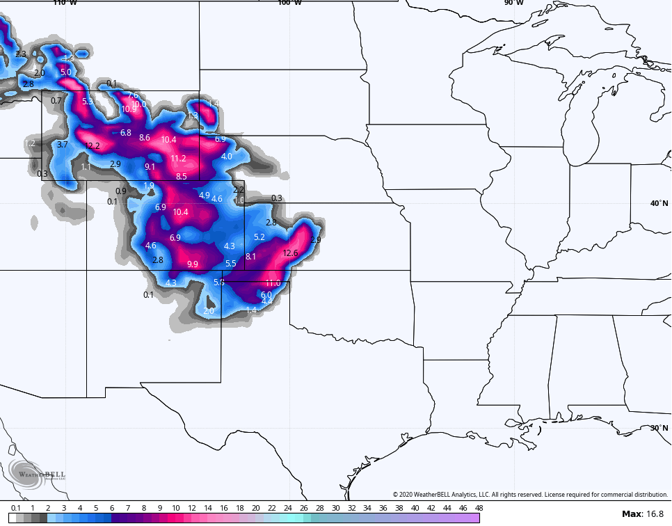
That’s insane to see this early in the season. Snow into the Texas Panhandle and western Kansas?? I will have some interesting stats on early season Denver snow coming later today or tonight.
This snow and cold is courtesy of the mega trough diving into the Rockies and plains. This becomes cutoff then slowly works our way by the end of the week and weekend…
 That brings an increase in showers and storms as this slow-mover nears. This action may show up as early as Wednesday, but the main threat blows in for Thursday and Friday…

Once again, the timing on all this is far from being set in stone, so stay tuned for further changes. 🙂
I will update things later today. Have a good one and take care.

Thanks Chris, yesterday was absolutely beautiful here in central Kentucky for doing any outdoor activity. After today it’s back, the heat and the high dew points to go along with it. Ugh ! But it’s still Summer remember. We will have to wait on “real Fall weather” for a while longer. Maybe October or November ?
Wow, that is really interesting weather predicted for the central Rockies and the western plains. I don’t recall such a weather scenario contrast. If it plays out like predicted “thunder snow” most likely will occur.
Tropics are picking up some action. I wouldn’t be surprised if there is a named tropical storm or hurricane by the end of next week ?
Schroeder, I participated in a particular Christian message board a little over a decade ago. One of the other posters had lived most of his life in the likes of Denver and Colorado Springs (which is even higher in elevation than Denver). One day to his dismay and annoyance, snow was falling while he was typing his message board post…and it was early June! It had been in maybe low 90s a day or two earlier! He said Denver/Colorado Springs get measurable snow in early June every long once in a while so it’s unusual but not unheard of.
As a side note, my brother has been in Denver during January when it was in the 60s!
Unlike the feeling of the large number of snow lovers that will soon return to KWC in the coming months, I’ll hang on to summer as long as possible! 😉
It’s really amazing the wild temperature swings the Denver area can experience! After the near 100-degree temps today, the snow and 30s on Tuesday, the temps are predicted to return to the 80s by this coming weekend there! That’s crazy!
My sister and brother-in-law from FL are currently on vacation in Denver visiting family. I hope she brought some cold-weather clothing, as the cold and snow will be quite a shock to her and she is not used to it at all.
winter is definitely not my favorite season. since we must endure it, it might as well give us a decent snowstorm or 2. but above all, give me warm temps and sunshine year round. by the time February rolls around and we get that late winter tease of warmth, its the best feeling ever knowing winter is nearly over. TennMark, im right there with ya. ill hang on to summer as long as possible!
its quite satisfying looking at the western sky on a late january evening and seeing the soft glow of longer days…..
You and I seem to be a small minority here at KWC!
To further complicate things, I’m married to a snow/winter lover! Although even my wife is not ruling out us retiring to a warmer climate. Whether we will be able to afford to do so may be another question! 🙂
Also brings up the question will our young daughter be a snow lover, or will she like all season warmth when she grows up?!! Hmmm! 😉
Mark, My niece use to live in Snow Ma*s*s Village, Colorado and when she was visiting me here in Kentucky she was complaining about the extreme heat and humidity we had here in Kentucky. LOL
She said that the snows came early and stayed through May and June and when the mountain streams ran in the Summer the fishing was unbelievable.
Now were talking about an elevation of 12,000 feet and she lived not too far from Mt. Elbert which is the highest mountain peak in Colorado at an elevation of !4,233 feet.
Sounds like the perfect place for me to live if I was 22 years old again. LOL
I’ve only been to Denver a couple of times including for business and to change planes. But I know a Tennessee couple (both lawyers) and their now grown kids that routinely winter in Snowm-a-s-s/Aspen to hit the slopes. However, at least once they visited during the summer and said they were pleasantly surprised how nice it was. Among other factors, Aspen is far less crowded during the warmer months.
I’m only in my 30s, but I sometimes already long for my early 20s! Even if I would opt for a warm weather place with water skiing instead of snow skiing!
Thanks for your tireless efforts, CB! Nashville TN officially dropped to 59 this morning. As usual, even cooler up on the higher elevations of the plateau.
Our little girl absolutely loved being outside yesterday in the splendid conditions as we all went to see my in-laws. First time granddaughter and grandparents have had a real meeting since March….thanks to all doing frequent testing. Sad to think of all the many good times COVID-19 had robbed from people. But this dangerous virus is not exactly tiring of us so we have to continue to stay safe.
Have a great, safe Labor Day weekend, fellow weather weenies!
Likewise. TennMark!
We had a much-needed, steady and soaking rain along with a few rumbles of thunder this Sunday morning across Northern IL and the Chicago area. As the area clears out this afternoon and temps warm to near 80, that will destabilize the atmosphere and will bring a severe weather threat this evening as thunderstorms develop. The Chicago area is in the slight risk category for severe weather, and a weather watch will likely be issued.
Monday night through Thursday looks very unsettled here, with frequent rain chances. Our short-term drought looks to be history, as most of the area will likely 2-3 inches of rain by the end of the week, much more than the half-inch of rain or so that fell throughout the entire month of August.
You all in Kentucky/Tennessee enjoy your dry weather for the next few days!
Glad you got rain Mike to help with the drought. This coming week, here where I live in central Kentucky the forecast is for mostly dry and very warm.