Good Monday, everyone. It’s Labor Day and, for many, the unofficial end to summer, and it’s been one heck of a weather weekend across Kentucky. In honor of this nice day, I have a blowout post for you guys. We cover everything from the good weather to start the week, to the tropics, to a slow-moving storm slowly heading our way late in the week. What will get your attention is the Denver snowstorm and if early season snow there means anything for us later in the winter.
Let’s begin with today and kick it into high gear. Highs are mainly in the 80-85 degree range for many with a mix of sun and clouds. There is a cold front to the north and northwest of us and it may get close enough to spit out a shower or storm in the far north. Here are your radars to see just how close this action gets…

The forecast for Tuesday is warm and dry, but there’s a small shot for a storm creeping into the east on Wednesday.
It’s during this time we will need to watch for something tropical off the southeast coast. The latest from the National Hurricane Center shows this system as one of several to watch…

That’s the system I’ve been talking about throwing up a stop sign to the massive trough in the Rockies and plains. As that system works west, it may actually bring a shower or storm into our region by Thursday…

We will have to see just how strong that system can get. Can it become a named storm? That’s certainly possible and something for us to watch.
The western system then slowly works toward the northeast and brings an increase in rain and storms to us this weekend. That may try to meet up with anything along the east coast…

That’s when you would finally get the cooler air back in here.
As you have been reading on here for days, Denver is going from historic 100 degree high temps to snow in roughly a days time. Some MAJOR snows are likely to fall in the region over the next few days…
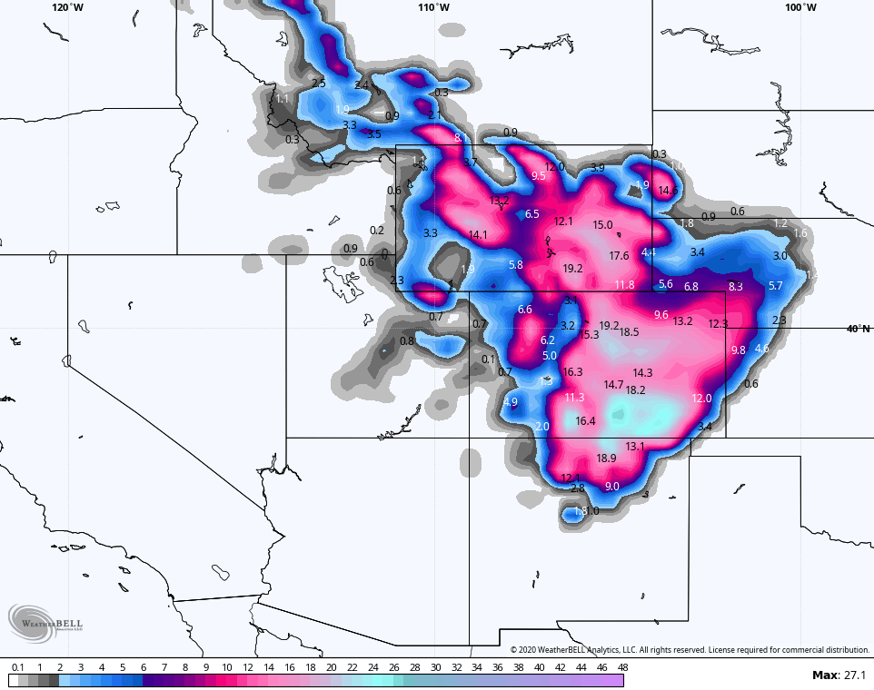
Here’s the Denver forecast from the GFS…
Again, it’s in the 90s today and will be snowing tomorrow.
I started digging around to find similar early season snows in Denver to see if they had anything in common. According to a story in the Denver Post, here are the top 5 earliest measurable snowfalls in modern history:
1. Sept. 3, 1961
2. Sept. 8, 1962
3. Sept. 12, 1989
4. Sept. 12, 1974
5. Sept. 24, 2000
All of those years were characterized by a La Nina or a cold neutral signal in the equatorial Pacific Ocean, which matches what’s happening now in the Pacific as a weak La Nina is developing. That doesn’t mean I’ve discovered some holy grail, but it’s interesting to find some correlation.
What happened around here during those following winters? Did they have anything in common?
Let’s take Lexington as the focal point for this:
- The winter of 1961-62 was much colder than normal with record cold in January. It was also a little above normal for snowfall.
- The winter of 1962-63 was historic. It featured below zero temps in each month. Record lows were also set in each month, including the coldest temps ever recorded with -21 and -20 on back to back mornings in January. It was also the 4th coldest winter on record and featured above normal snowfall.
- The winter of 1974-75 is the only winter where there was really nothing outside of the ordinary showing up for cold. Snowfall was close to average, though.
- The winter of 1989-90 was also historic. It featured the coldest December on record with 8 days with lows going below zero. 7 of those set record lows, including the coldest December temp every recorded at -19. Snowfall was much above normal for the month. This pattern flipped on a dime with January and February going almost snow free with record warmth.
- The winter of 2000-2001 featured the 2nd coldest December on record. Not a single morning dipped below zero, but we did get into the single digits many mornings. This was a consistent cold that gripped the area. Snowfall was much above normal and well above the official total. That’s back when the NWS didn’t have an observer to actually measure snow and just guessed from 80 miles away. January featured above normal snow and slightly colder than normal temps. The pattern broke quickly in February.
So, is there any kind of concrete conclusion we can draw from all of this? Not a lot in weather is concrete, but there certainly are some takeaways:
- Early season snow in Denver seems to occur during La Nina or cold neutral signals.
- 4 of the 5 years featured then brought some kind of historic cold into Kentucky during the following winter.
Now, we wait to see what the winter of 20-21 brings. 🙂
I will have an update later today, so check back. Until then, make it a good one and take care.

Northern IL missed out on the severe weather on Sunday night, as only a few isolated showers developed. But the Chicago area received around 2/3 of an inch of rain from Sunday morning, which was very beneficial.
After a pleasant, sunny day today with highs in the 70s, the rain returns off-and-on from Tuesday through Thursday. Great day to be out today though for a long power walk in the forest preserve here.
My gosh, those predicted snow amounts for Colorado and surrounding areas would be absolutely crazy for December or January, let alone early September. I would think that with several days of temps well in the 90s there, the ground would be much too warm for a significant amount of snow to accumulate, but I guess I’m wrong.
Mike, I might be wrong too on this about the snow accumulating on above freezing soil and asphalt. In the year 2004 we had a major snowstorm on the 23rd of December and the temperatures prior to that were very much above freezing. When the snow is wet it falls hard and furious and accumulates because it doesn’t have time to melt. Anyway we had a beautiful rare White Christmas that year and everyone made it home for Christmas.
I don’t know Chris if you could predict the Fall and Winter by what’s predicted to happening in Colorado tomorrow. My opinion.
The only Winter on your list that stands out to me was 1962-63 where we maintained a snow cover from early December through March at basketball sectional time. This was in south central Indiana where I grew up.
I can really believe that our Falls and Winters over the past several years have followed a consistent pattern and with all the time I’ve spent studying climatology and meteorology I don’t see that changing. Again my opinion.
It looks like September is living up to its reputation as being the driest month.
I don’t think there is any wet or dry months in our climate here in Kentucky, but usually October is listed as our driest month or September.