Good Monday, everyone. It’s a very busy weather day across the Commonwealth as a potent fall cold front works through. This is bringing showers and strong storms, gusty winds and a major temperature swing to straight up chilly. As the week wears on, temps turn cold for this time of year as we roll into early October.
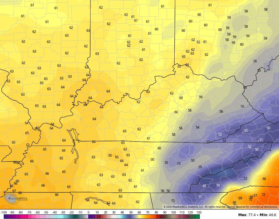
Today’s front has one healthy temp swing along it with temps spiking to 80 ahead of it in the east, and temps dropping into the 50s as it moves through. Some areas will see a temperature drop of 25 degrees in just an hour or two this afternoon and evening. Given this stout temp gradient, there’s the chance for a few strong storms to go up. The best chance for this is across the eastern half of the state and that’s where the Storm Prediction Center has a low-end risk for severe storms…

Damaging winds will be the main threat from any strong storm. As a matter of fact, gusty winds will be an issue all along the line of showers and storms. Those gusts may reach 40mph in a few spots as the front slams through.
A wave of low pressure develops along the front as it moves just to our east Tuesday. That keeps showers going across eastern Kentucky with clouds slow to break into the central part of the state. All this means temps in the east may stay in the 50s all day long with readings of 60-65 elsewhere…
Wednesday looks like a very nice fall day with a mix of sun and clouds and highs in the 60s. Winds will gust up during the afternoon as a bigger push of chilly/cold air moves in as we kick off October on Thursday. This may be accompanied by a band of showers and may even produce a shower on a northwest wind for Friday…

This will be followed by very chilly air for Friday and Saturday. Highs both days may very well stay in the 50s for many with lows in the 30s. If we have clear skies, some frost will certainly be possible.
Another system will then drop in here behind that as we head into late Sunday and Monday.
I will have updates later today. Until then, here are your storm tracking tools for the day…

Current watches

Possible Watch Areas

Have a magnificent Monday and take care.

Thanks Chris, this time the atmospheric pattern over the central and eastern US is showing a “major change.” The polar jet is finally taking a turn to the south over the central US.
This brings back memories of late September 1976 where the weather pattern changed abruptly and gave us a very cold October.
Thanks, Chris.
With fall comes increased chances for severe weather including tornadoes. While not as risky as the spring months, on average the fall threat peaks in November as among other issues the strengthening Jetstream causes more chances for shear thus tornadic weather. So, Sky Warn spotters c-l-a-s-s-e-s (mainly online due to COVID-19) are up and running. NWS Paducah and NWS Nashville have Sky Warn training sessions scheduled
https://www.weather.gov/ohx/skywarn
But other NWS offices in our area likely do as well, or will soon.
https://www.weather.gov/skywarn/wfo_links
There is also CoCoRaHS (Community Collaboration Rain Hail & Snow Network). Perhaps many snow lovers have not yet returned to this blog, but surely many of them would enjoy reporting snow cover this coming winter! At the same time, weather information reported from volunteers remains valuable…especially from more rural areas.
Consider joining one or both of these programs.
Neglected to include link for CoCoRaHS.
https://www.cocorahs.org/
Also, info about Fall Severe Weather Awareness Week Sept 28 – Oct 2, 2020
https://www.weather.gov/pah/FallSevereWeatherAwarenessWeek
Great information Mark, I remember we had a stretch of severe weather including tornadoes in November while I was living near Evansville, Indiana.
I use to keep snow records for a local TV station in Evansville. I lived just north of town and they needed someone to report such.
I remember the horrific Nov 2005 tornado that struck the Evansville trailer park as well as the F4 that did a glancing blow to Madisonville KY. Looking at satellite pics, a lot of concrete slabs on the southern end (which took the direct hit) of that trailer park remain empty.
Nashville TN has not have a “real” snow since January 2016 when I measured about eight inches on our driveway. Despite me being a warm weather person, I can accept a little snow around Christmas like what occurred in 2010.
That’s good that the NWS in Kentucky and Tennessee have the severe weather programs for the fall. The Chicago NWS doesn’t, but there certainly can be severe weather here in October and November.
During that Sunday in November 2013 severe weather outbreak, the Bears were playing the Baltimore Ravens at Soldier Field, and the game had to be stopped for two hours because of intense lightning, and a Severe Thunderstorm Warning which was issued for Chicago. Soldier Field was evacuated for the first time ever! The fans had to take cover in the concourses.
My wife and I, recently married, were visiting her parents in Bowling Green KY during the Nov 2013 outbreak. The tornado sirens were blaring as we got to see above us a fascinating if sobering example of directional shear (clouds at only slightly different heights moving in very different directions).
Same day as the EF3 that passed within sight of the Paducah office of the NWS. That tornado then crossed into Illinois causing several fatalities.
My wife and I were recently married and visiting her parents in Bowling Green KY during the November 2013 outbreak. The tornado sirens were blaring even though radar showed the possible tornado well to the north and not heading our way (I understand in many communities the sirens will sound all over the county even if the threat is in one narrow area). However, we still got to see above us a fascinating if sobering example of directional shear (clouds at only slightly different heights moving in very different directions).
This was the same outbreak that produced the EF3 that p-a-s-s-e-d within sight of the Paducah office of the NWS. That tornado then crossed into Illinois where several fatalities occurred.
We had a steady, soaking rain for several hours here in the Chicago Metro Area late last night and early this morning, which brought an end to 13 days in a row without any rain.
Also, the last six days have featured temps well above normal, with highs in the upper 70s to near 80. That’s coming to an end today too, with highs in the low 60s with a breezy west wind. Temps will be even colder later this week, just like in Kentucky.
Looking forward to my power walk later today in the forest preserve near me with the cool weather, and to see the leaves changing color, which is pretty noticeable here.
I have a close friend that lives in Northbrook so I always enjoy and appreciate seeing your Chicago area weather reports. Enjoy that power walk!