Good Sunday, everybody. Here’s hoping this post finds each of you living your best life. We have a cold front dropping into the region from the northwest and it’s going to slow down right on top of us. That allows for a wave of low pressure to work through here over the next few days and that spells rounds of showers and storms for parts of the Commonwealth.
Clouds are rolling in today with a few afternoon showers and storms developing across the west. Here are your radars to track the increase in the action…

Showers and storms increase tonight into Monday and likely hang around into Tuesday. The greatest risk for stronger storms and heavy rainfall continues to be in the areas I’ve outlined over the past few days…
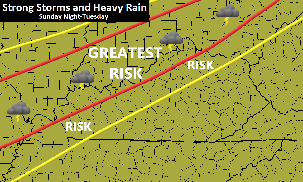
The Storm Prediction Center is also highlighting parts of the state with the low-end risk for Severe Storms on Monday…

Temps behind all this will spike well into the 70s for the middle of the week as we get set for another front on Friday.
As all of this is happening, the tropics are flexing a little late season muscle and that’s exactly what you would expect in this hyper-active season…

How much development do we get and, if so, where do these systems go? That’s really going to have a big say in how the whole pattern sets up from the weekend into the final week and change of October.
The GFS has our Friday front deflecting the Atlantic system…

That allows for a much deeper trough and system to work in after that, but the evolution is out there in la la land for now…

Even the EURO Ensembles are showing the potential for some flake action before the month is over…
I will have another update later today. Have a good one and take care.

Doesn’t sound very “Fall Like” for the middle of next week.
I hope the areas that need the rain get the rain.
NOAA release their Winter outlook this morning.
I am not surprise at what they are predicting.