Good Tuesday, weather weenies. Our front is starting to move back to the north and that’s allowing much milder air to move in for the next few days. This mild air is in between fronts with the next one set to arrive Friday with more showers and storms. This kicks off another very active pattern that brings a big fall/winter storm system our way early next week.
Let’s kick this thing off with what’s happening out there today. Scattered showers and storms are still floating around, especially in the west and north. Some of these areas have picked up a lot of rain in recent days so we will have to keep an eye on additional storm action. Here are your radars…

Temps across the north are in the 60s with the 70s in the south. Those 70s are surging northward for the next few days as temps turn a little toasty for this time of year. Winds will be coming at us from the southwest and will be rather gusty. Humidity levels will also be elevated for this time of year and that may fire off an isolated shower or storm.
Rain and storm chances increase Friday as moisture streams in from the Gulf of Mexico at the same time a cold front approaches from the northwest and that may linger into Saturday.
If you’ve been with us over the past several days, you know my thoughts on the tropics backing up the pattern across the country. Once Epsilon gets out of the way in the Atlantic, we can get the trough to dig into the eastern half of the country. The models continue to exhibit wild swings from run to run as they try to figure out when this all happens. The latest GFS is quicker…

Here’s how that looks with the first front on Saturday then the bigger system early next week…

Again, the evolution and intensity of the setup is yet to be determined. Certainly the above run is frigid and takes on a winter look.
Last week, NOAA put out their winter forecast which really isn’t a forecast at all. It’s technically giving you probabilities…

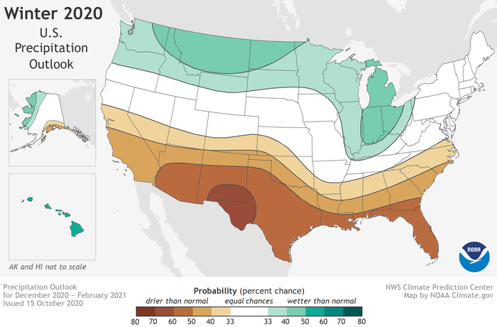
How much warmer or colder? .10 or 10 degrees? How much wetter? .10″ or 10″? How do we get there? One month could be blazing hot and another month be arctic cold and would cancel one another out.
I rarely share these because they aren’t forecasts, but this one stood out. Why? Because it’s essentially just following the computer averages from all La Nina’s since 1950…
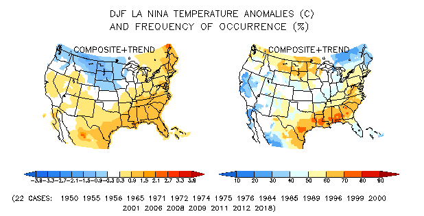

This is just silly because zero of those years were exactly the same and you have some MAJOR variability in there. For one… there is no differentiation in La Nina in terms of strength or placement. All of those years had different outcomes in terms of actual weather across the country and around here.
I’ve blown my share of winter forecasts, but it’s not going to be because I simply take an average of 22 years and say there ya go, folks. 🙂
This tweet from our friend Dr. Judah Cohen illustrates what I’m talking about…
La Niña is thought to favor a mild #winter in the Eastern US but recent La Niñas feature many large #polarvortex disruptions which is often followed by severe winter weather not only in the Eastern US but elsewhere across the Hemisphere: https://t.co/aig1SujLNf pic.twitter.com/Fwjyb83wli
— Judah Cohen (@judah47) October 19, 2020
Some good stuff there!
I will have another update later today, so check back.
Have a good one and take care.

In the last 48 hours we received 0.49 inches of rain in my county of Taylor. A good slow soaking rain but now I’m ready for some colder weather with Sunshine.
Seems like the tropical Atlantic dictates more now on what weather type we will receive.
I looked up the year 2009 (weak La Nina year) and that was the year we had the worse ice storm in the state of Kentucky.
I don’t know how one can discuss ENSO years without comparisons.
All I can say is that our cold and snowiest Winters occurred during weak El Nino years. Case in point 1969-70 and 1977-78.