Good Sunday, everybody. It’s another chilly and dreary day across the bluegrass state and this looks to continue for a few more days. At the same time, the winter verses tropics battle is well underway and it’s leading to an extreme pattern across the country. The battle looks to bring tropical moisture into Kentucky before the upcoming week is over.
Let us begin, as always, with what’s happening out there today. Temps range from the chilly upper 40s to middle 50s for many, but the numbers will spike into the 60s in the far southeast. A few waves of showers will be noted, with the greatest concentration across central and eastern Kentucky…

Monday looks like another raw day with temps struggling again as additional showers move through here and that looks to be a similar trend for Tuesday. I warned you guys the models would be too warm and not handle this setup well.
Now, let’s talk about the major extremes going on across the country as both are going to impact our weather to some extent. Zeta continues to develop in the Caribbean and is forecast to head into the Gulf of Mexico over the next few days. The track from the National Hurricane Center does bring the remnants our way later in the week…

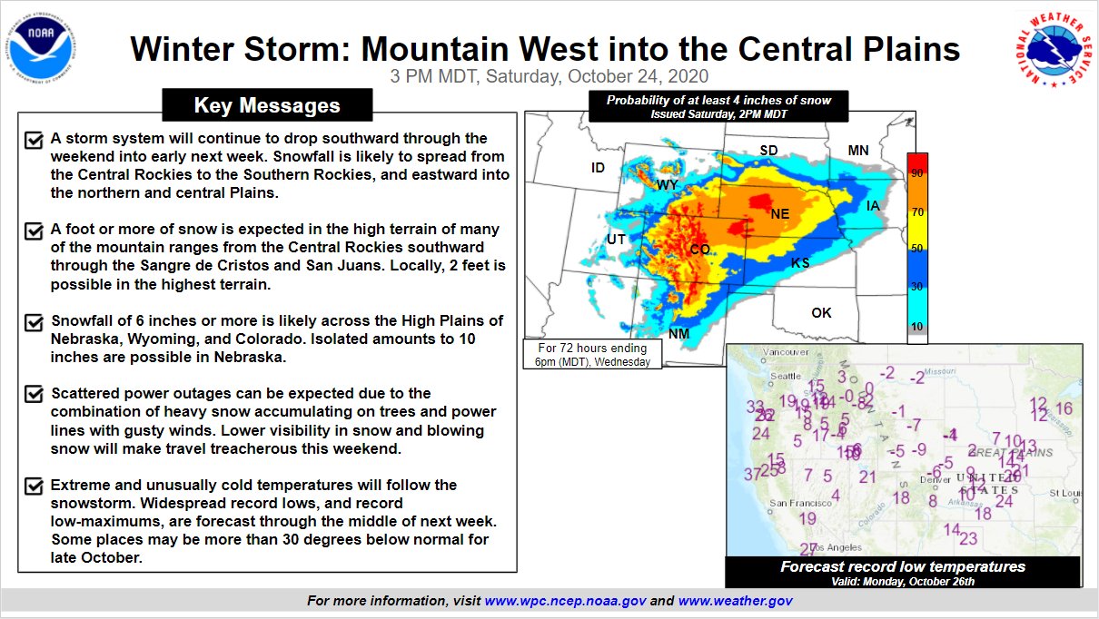
I’ll get back to that system in a bit. The historic early season winter pattern continues to unfold across the Rockies and plains states. We’ve already had many areas with the snowiest October on record, but the worst is coming the next few days. Record cold and record snows will blanket a lot of real estate. To show how extreme this is, the NWS/WPC is even talking about it…
Do you see some of those record lows being forecast? Well below zero in October is crazy cold.
The trough bringing the historic winter weather to our west is going to send another system at us for the second half of the week. That storm system will be coming from the southwestern part of the country and merges with Zeta, potentially bringing a lot of rain and wind our way…
I’ll update this setup later today. Until then, have a great Sunday and take care.

The next few days I will be following the Arctic air moving south into the Texas Panhandle.
It would be interesting if this merges with a disturbance along a weak subtropical jet stream.
May be a blizzard in the central and northern plains states if this happens ?
Too early to predict the exact path of Zeta, but I’m sure it will bring Kentucky more tropical weather.
Next weekend it is predicted to be Sunny with highs in the 60’s here in central Kentucky.
That looks exciting! Perhaps it portends a cold and snowy winter for us!
We can only HOPE, mike…LOL! I don’t think there’s anyone out there that wants to see another Jan. ’94….or “77-78 Winter more than me!? (OK…there’s more of us out there!) Heck, I’m so crazy-nutz over winter wx that I’d even like another ’09 ice storm…ok, maybe not as extreme. I value mine and others’ lives more than that, but I have always been a winter wx lover. I just turned 58 this past week, and there is still NOTHING in this world I love more than a good winter with lots of snow, etc. Last year was just about one of the worst…. a little 1” “toe-tingler” the first of Nov. and then barely a flurry afterward. {{{sigh}}} Let’s keep our fingers crossed that this will be OUR WINTER!!!! 🙂
I would like to see a little more sunshine in the forecast.
I agree. This dreary weather is depressing and we’ve got enough of that going around.
I just looked at the Goes East and Goes West satellite imagery and found that two thirds of the country is covered in clouds.
Kind of unusual for this time of the year.
The first hard freeze for my county of Taylor is going to be late.
If the Sun was shinning this afternoon, this would have been a beautiful Autumn day with the foliage at near peak.