Good Saturday and Happy Halloween! It’s honestly hard to believe we’ve made it to the end of October and we have November ready to kick off the cold weather season. Right on cue, we have a big blast of cold air surging our way late on November 1st and that may try to spit out a flake or two in the east.
Let’s begin things with your Halloween Forecast. Temps are in the upper 20s to middle 30s for many to begin the day. By the afternoon, a mix of sun and clouds will be noted with temps from the middle 50s to lower 60s. This sets the stage for a great evening for trick-or-treaters. Enjoy!
Don’t forget to set those clocks back one hour before going to bed tonight!
November starts with a deep, quick-hitting, trough diving into the eastern half of the country. This brings a cold front across the state Sunday with a few gusty showers and temps in the 50s ahead of it. Once the front slams through, temps crash from northwest to southeast and wind up in the 30s by evening. Some light snow and flurries will show up across Ohio and West Virginia, but can we get some of those flakes into the eastern half of Kentucky?
A few of the models continue to suggest this potential…

Lows behind this drop deep into the low and middle 20s by Monday morning. With a bit of a wind blowing, wind chills may reach the upper teens for a time. Watch the wind chill numbers from Sunday through Monday morning…
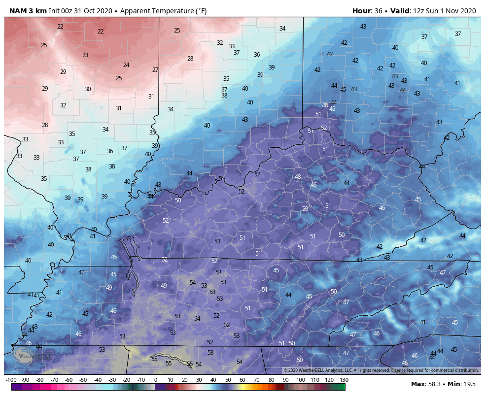
The rest of the day is more typical of the winter with highs in the 40-45 degree range for most.
Election day continues to look nice and the weather gets better from there. An extended run of dry and pleasant November weather takes us through the rest of the week into next weekend. Once into the following week, the pattern really changes up. I still think the tropics have one more say in the overall pattern and we are likely to see ETA develop out of this…

Some of the models keep this slowly moving around in the Caribbean before lifting northward toward the Gulf. That’s something to watch for in the following week.
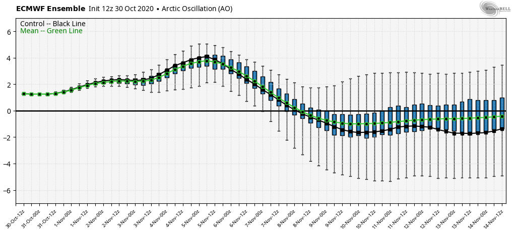
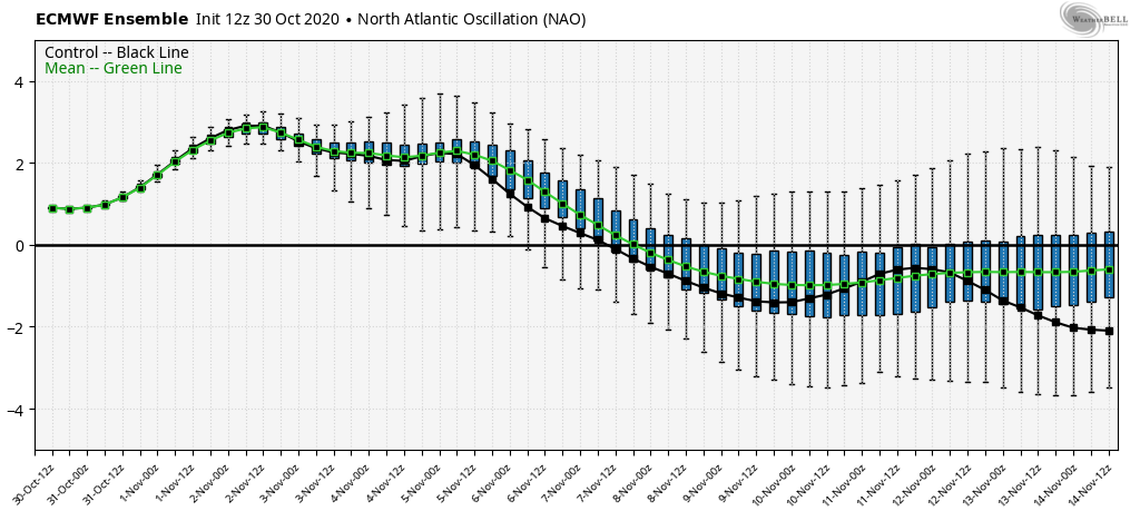
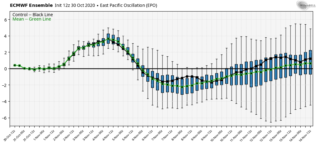
One of the ways we can target these changes is by looking at some of the global indices like the Arctic Oscillation, North Atlantic Oscillation and the Eastern Pacific Oscillation. Those are three of the biggies that can signal some semblance of the blocking it takes to turn our weather colder. When looking at the straight up index of each, you want to see them in the negative range if you’re a fan of cold and winter.
The Euro Ensembles show how we flip these into the negative range for the middle of the month…
AO
NAO
EPO
If we take the Euro Weeklies even deeper into the month and early December, we find a decent look…
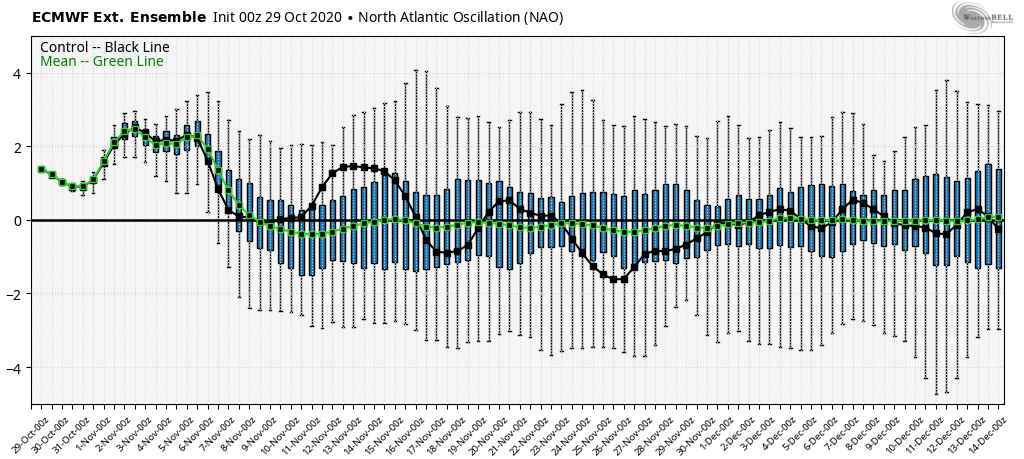
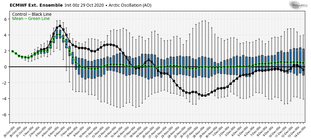
We’ve spent the majority of the past few winters with a +AO and a +NAO and we say how those turned out. As we’ve seen so far this fall, the overall pattern continues to be much different from recent years and, according to the indices above, this may continue right on into the start of winter.
I will have another update later today, so check back. Have a Happy Halloween and take care.

Here In NW PENNSYLVANIA our local weatherman put out his 2020-21 winter Outlook which calls for well above normal temps and well below normal snow fall.
FFK, I would take that with a “grain of salt.” Usually during La Nina years the “lake effect machine” kicks in big time !
It’s a cold, below-freezing morning here in the Chicago Metro Area, with temps near 30 degrees. Unlike last year’s historic Halloween, which was our snowiest Halloween ever by far with 2 1/2 inches of snow and a high in the low 30s, it’s going to be sunny, breezy, and seasonable today with highs in the mid 50s.
I just hope that we will have enough moisture from the Subtropical jet stream when it does turns cold to produce snow and not ice this winter ?