Good Monday, everyone. Our week is starting out absolutely frigid with temps deep in the 20s to start the day. While the numbers continue to run below normal this afternoon, things are about to turn very pleasant into Election Day and beyond. While we enjoy the nice stuff this week, it’s looking more and more like next week brings some big changes to much of the country. The tropics and winter will try to do another slow-dance together.
Guess what happened last night? The first flakes of the season did make an appearance in Kentucky as a few snow showers and flurries moved across far eastern and northeastern Kentucky. Take a look…
The first confirmed snow for the 2020-21 winter has arrived in Worthington. @SpencerWeather @Kentuckyweather #kywx pic.twitter.com/vs415emEhv
— James Collier (@CollierSZLive) November 2, 2020
Snowflakes in Raceland @Kentuckyweather pic.twitter.com/OYXzEYTLAB
— Jason (@readingtall) November 2, 2020
I love it when a plan comes together! 🙂
Low and middle 20s start today with a wind chill dipping into the upper teens at times. Highs this afternoon range from the low to middle 40s with a mostly sunny sky.
Election Day looks great with upper 20s to start and 50s for highs. From there, things turn a little milder with highs in the 60s and lows from the upper 30s to low 40s for the rest of the week. A 70 degree high temp will be possible at some point through the coming weekend.
While we are enjoying the nice weather, the 2020 tropical season continues to show up and show out. Hurricane ETA is heading toward central America…

Remember when the NAM used to be called the ETA? Awwww, the good old computer model days. Can we bring back the NGM? 🙂
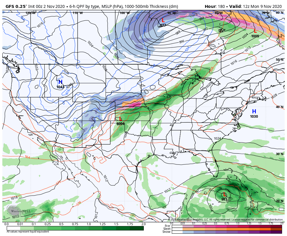
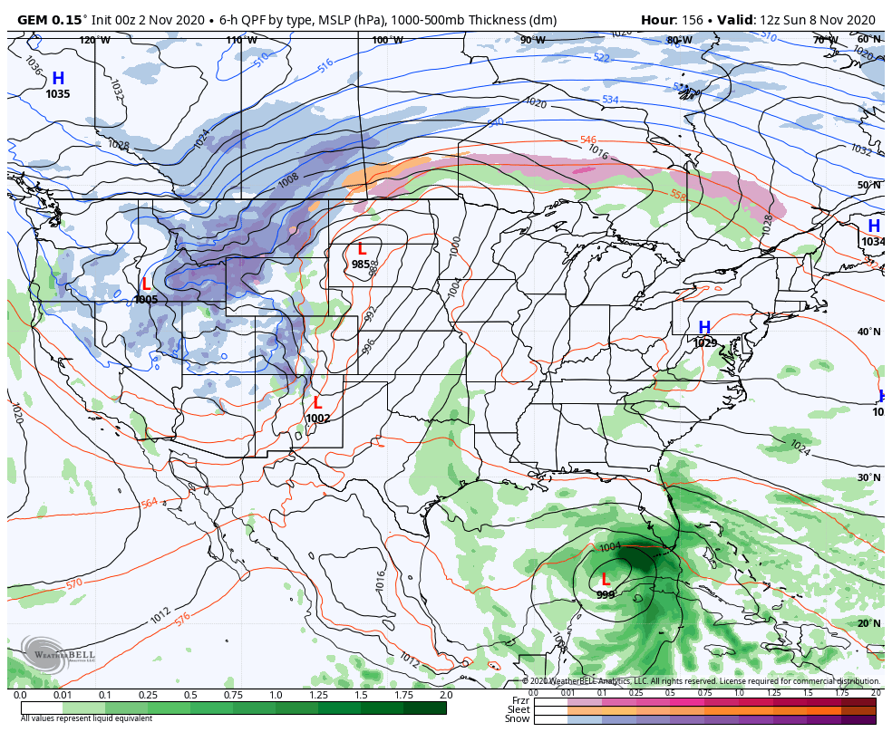
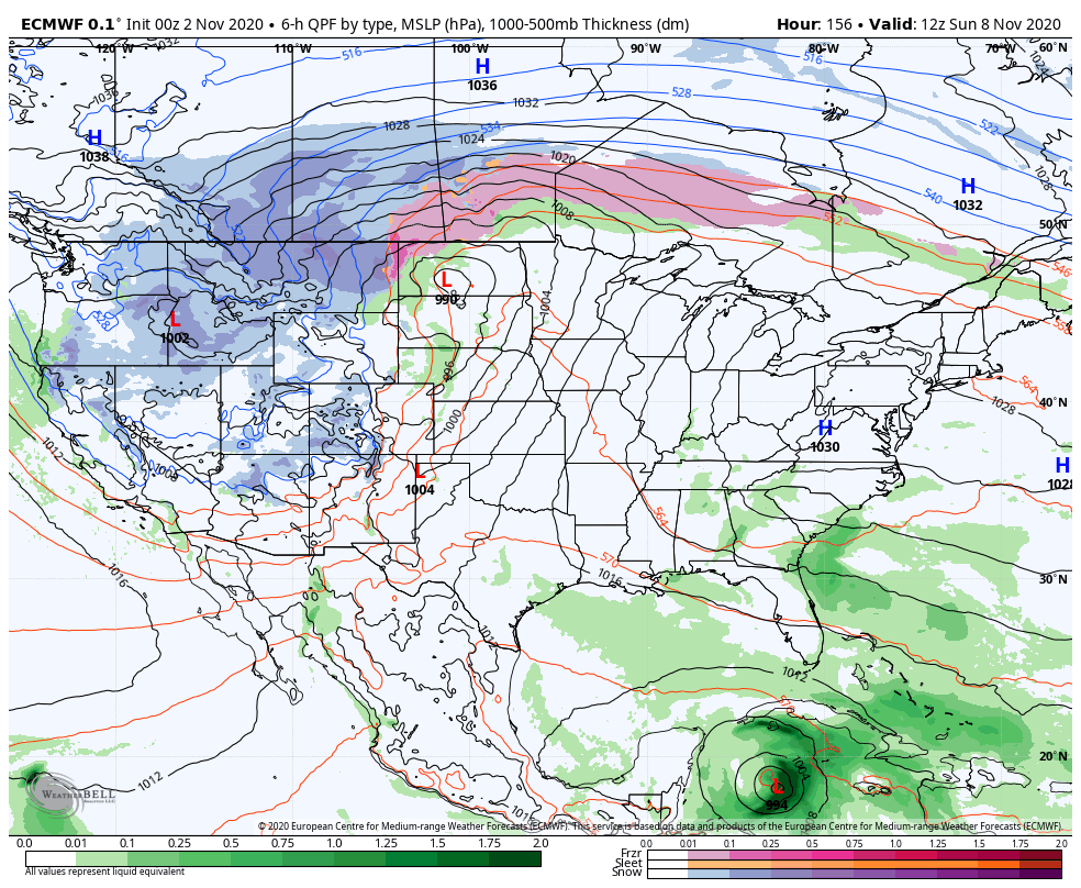
What eventually happens with ETA (the storm) is still a bit of a mystery as the models try to figure it out. Does that slowly lift north and head toward the Gulf or Florida? Does it just stay over land and dissipate? Or does something else form just north of it? All three options are on the table.
Further giving the models fits is another major dip in the jet stream across the western part of the country. That allows for more winter weather to take control and slowly expand eastward through next week.
The models continue to try to figure out another extreme setup…
GFS
CANADIAN
EURO
If you’re interested in talk about the upcoming winter, go back and check out some of my weekend posts.
Another post comes your way later today, so check back. Have a good one and take care.

Enjoyed the videos on the snow flurries in northeastern Kentucky. Those fellows did a great job capturing the action. With clippers coming through that area this coming Winter, that part of the state may be the big snow winners this coming Winter season.
Chris, I must say you have done a great job here lately forecasting what goes on in the Tropics and how it has impacted our weather here in Kentucky. Also you predicted the snow flurries that fell last night weeks ago. Great work !
26 degrees this morning in my backyard ending the growing season here in central Kentucky.
Good week of weather to do those outdoor choirs before the weather changes again.