Good Monday, everybody. We are likely to see additional record high temps set out there today as we get ready for a potent cold front to swing in late Tuesday. This front brings gusty showers and thunderstorms our way and knocks the temps back down to seasonal levels with another storm system moving our way next weekend.
Let’s kick things off with talking about ETA. This is moving across the Florida Keys now and is becoming a hurricane as it settles toward the southwest. From there, this storm will meander around the eastern Gulf of Mexico and try to work back into Florida later in the week.
Here’s the latest from the National Hurricane Center…

Here’s a look at what the Hurricane Models have in store for ETA…

If you want to follow ETA and/or the northern Rockies blizzard, take the interactive radar out for a spin…
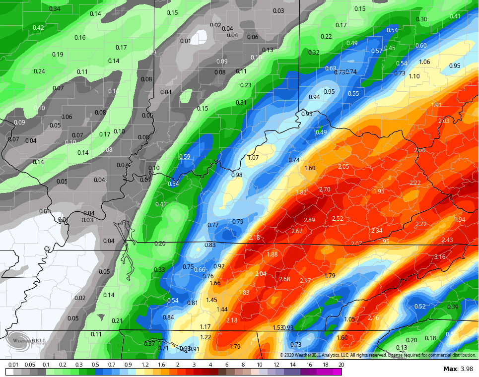
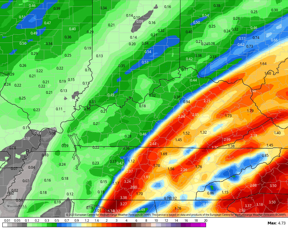
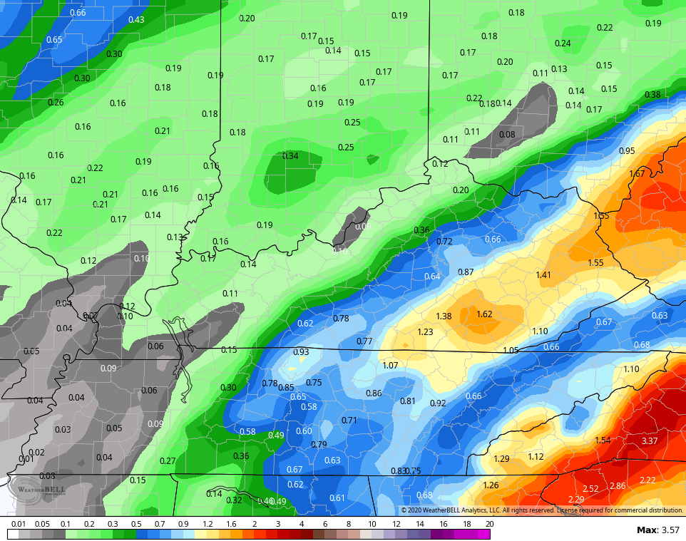
As far as our weather is concerned, we have a strong cold front blasting into the region late Tuesday into Wednesday. This will have a surge of showers and storms develop ahead of it Tuesday. Another band of thunderstorms then works through here along the front. The overall setup can bring heavy rains to central and eastern Kentucky and most of the models show this potential…
NAM
EURO
CANADIAN
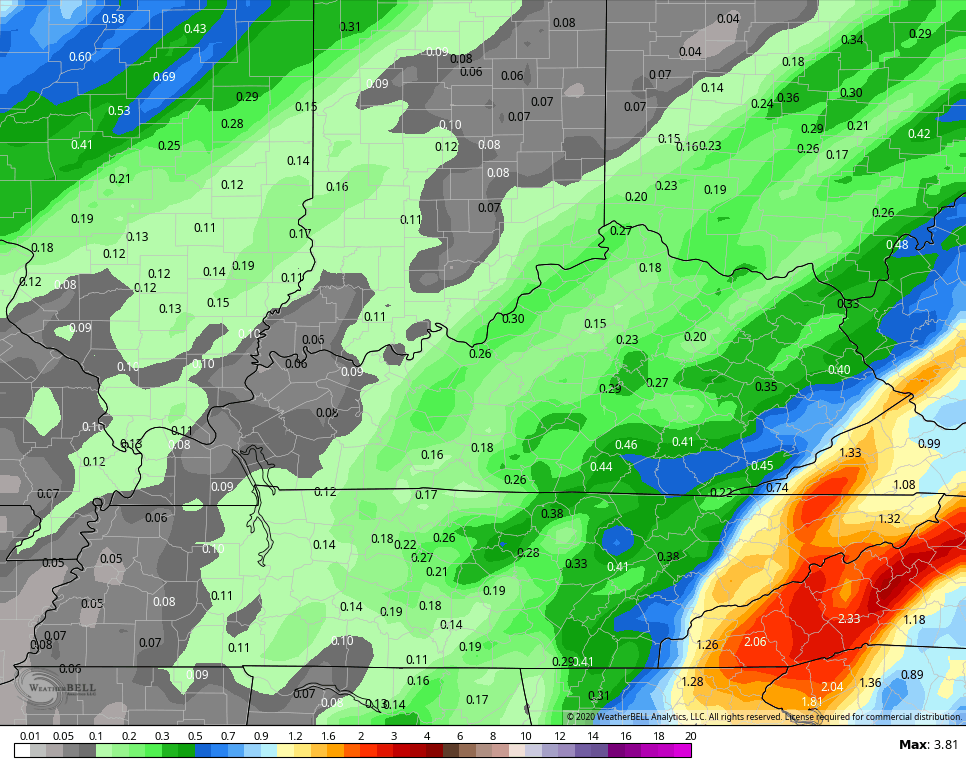
The GFS continues to be too progressive and the overall model appears to be having some serious issues through the entire run…
Seasonal temps come in behind this for the rest of the week, but we are likely to get another spike in temps ahead of the weekend storm system rolling in. How strong this storm is remains to be seen, but it’s likely to unleash much colder air behind it.
I told you guys in the last post that we would likely see the trough trend deeper and that’s showing up now…
EURO

CANADIAN

As you can see, we have lots of changes on the way over the next week.
I will have another update later today, so check back. Have a great Monday and take care.

That scenario with the weather models would be an abrupt change from what we have now and I hope it happens.
I have my doubts as another tropical system is beginning to form in the central Atlantic holding all the weather system’s eastern progression.
At this time it really looks like the Atlantic tropical season may dominate our climate well into December here in the eastern part of the country.
A “back loaded Winter ?”
On Sunday, Chicago’s O’Hare Airport hit a record-high for the date of 76 degrees, breaking the previous record of 73 degrees set in 1931. The low of 52 is what the normal high for the date should be.
Last year at O”Hare, the high temperature for November 8th was 32 degrees.
Yeah, last November was more exciting, unfortunately it was the only month we had some Winter weather.
I’m going to study the tropics and put the hope for Winter weather on the “back burner.”