Good Monday to one and all. A blast of snow and cold is surging into the bluegrass state today as a winter storm system rides up the Appalachian Mountains. This brings the first snowfall of the season to much of the region and the gusty winds will send our wind chills plummeting.
Once again, thanks for your patience with the loading issues KWC has been experiencing. Now that we are out of the holiday weekend, the design company can get in here and fix the issues. As frustrating as it is for you guys, I assure you I’m even more frustrated.
Ok, let’s get into the nitty gritty of the forecast. We continue to have two systems to track with the first on top of us early today. This is a stout low pressure working to our south and east up the Appalachian Mountains. This is bringing rain and snow this morning and the precip type depends on where you live. This will be followed up by an upper level low and strong northwest flow this afternoon through Tuesday morning. This brings widespread snow to central and eastern Kentucky.
Here’s a breakdown:
- This morning could be interesting as a band of heavy, wet snow tries to develop somewhere across central Kentucky. This would come from dynamic cooling and those are really difficult to forecast and one almost has to nowcast the radar.
- This would occur in an area of very heavy precipitation and may be surrounded by mixed rain and snow or just some plain rain.
- If this does develop, it would put down a quick thumper for some areas. That could be some serious slushy snow.
- Even if this doesn’t fully develop, rain will change to snow as the morning wears on. By the afternoon, the switch to snow has taken place from west to east as temps continue to drop and our upper low drops in.
- It may very well snow pretty good at times across central and eastern Kentucky from late afternoon through the evening. With temps dropping below freezing, accumulating snows are likely and road conditions go downhill quickly.
- Lake Michigan becomes involved on that strong northwest flow during the afternoon and evening. That enhances our snows.
- Winds will be gusty and could reach 30mph at times. This will actually be pretty awesome as it will give the snow a plaster effect.
So what about snow accumulations? Central and eastern Kentucky will see the bulk of the snow and this is the area I’ve concentrated on. This includes every flake that falls, including anything that falls and melts in the morning…
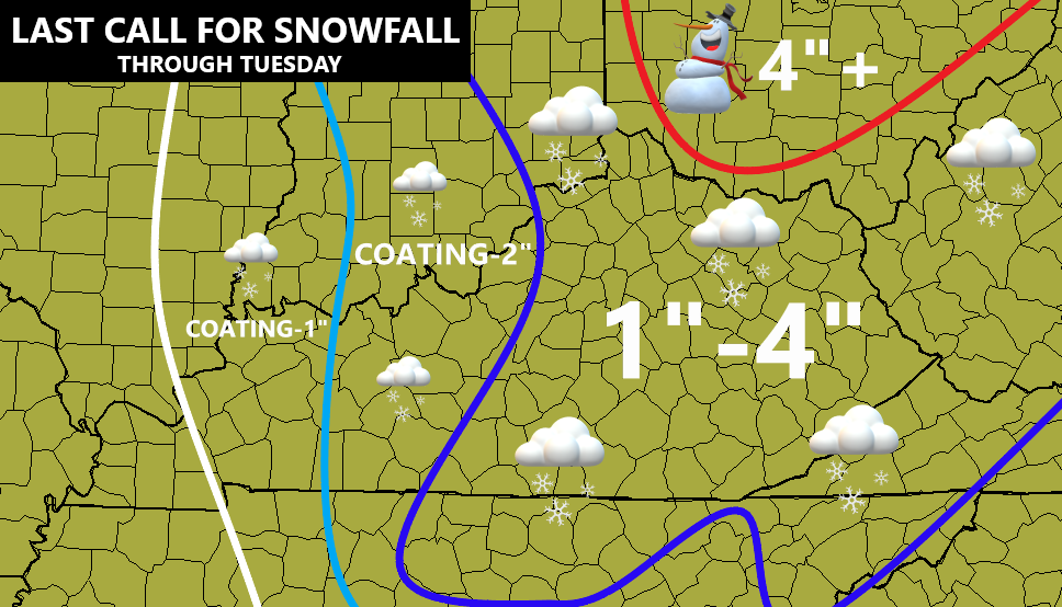
Will the lines be perfect? No. Will there be some spots in there that may get shafted and only pick up a coating or two? Probably so, but there could also be some areas in there that overachieve, especially in the Bluegrass Region if the morning band does develop.
By the afternoon, a plume of snow from Lake Michigan kicks things up a notch. Here’s the future radar from the Hi Res NAM for 4pm today…
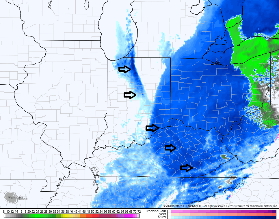
How awesome is that?? An enhanced snow plume from Lake Michigan all the way to southeastern Kentucky. Wow.
Important to note… If you don’t have snow on the ground this morning or even this afternoon… don’t freak. The greatest opportunity has always been late afternoon through Tuesday morning. Got it? Good. 🙂
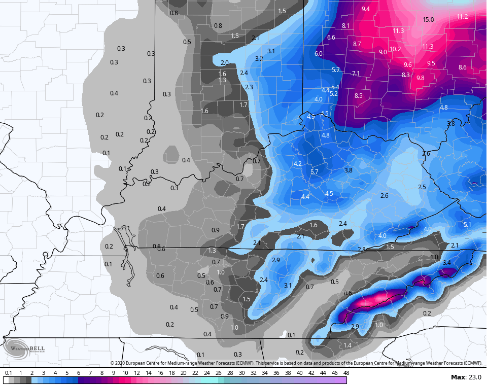
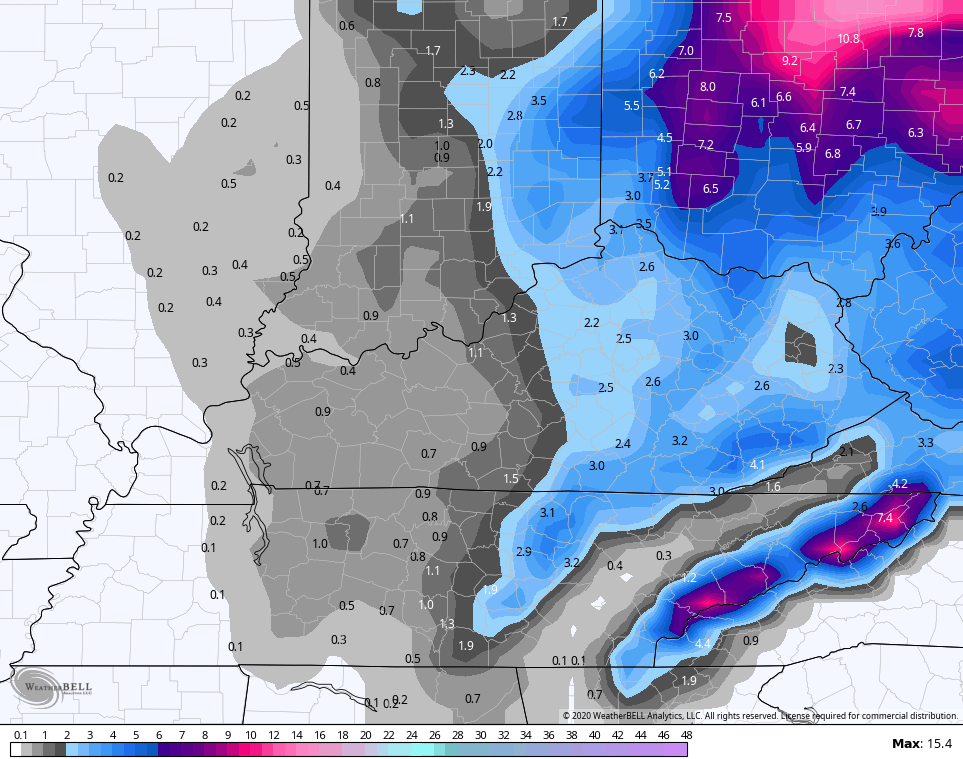
Here’s how the final run of the computer models look in terms of snowfall (not snow depth) …
EURO
NAM
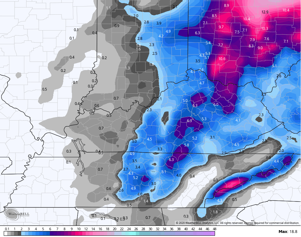
Hi Res NAM

CANADIAN
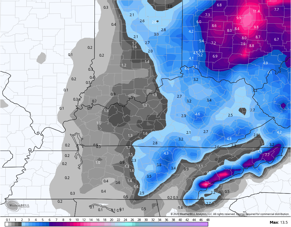
GFS
To add to our winter blast, we get wind chills way down there over the next few days as winds crank up. Look at the numbers from this afternoon through 7am Wednesday…

I’m actually scheduled to be off from WKYT today and tomorrow, but I may sneak in at some point later today. Regardless, I will have your usual multiple KWC updates.
Here are your radars to follow the transition from rain to snow from west to east. Keep in mind, the color coding on the radars may not match the actual precipitation type at times…

Have a great day and take care.

Looking forward to the switchover from rain to snow. Let’s hope it happens.
Last evening and through the night we received 0.58 inches of rain. Now with the dry winds of Winter the fire danger is held at bay for now.
At 5:00 am EDT snow showers were falling at a temperature of 34 degrees which amounted to a good coating of snow.
The snow showers have now past to our east.
No rain No snow at Hagerhill Johnson CO
Same here in Louisvt.
SNOW:[snoh] def:
Something beautiful in icy crystals falling from the sky that collects on the ground creating a calming and serene effect on people who love it, except for those in Nelson Co. We had our usual 18 flakes mixing in with the rain around Noon. Currently 35° and misty. 🙁