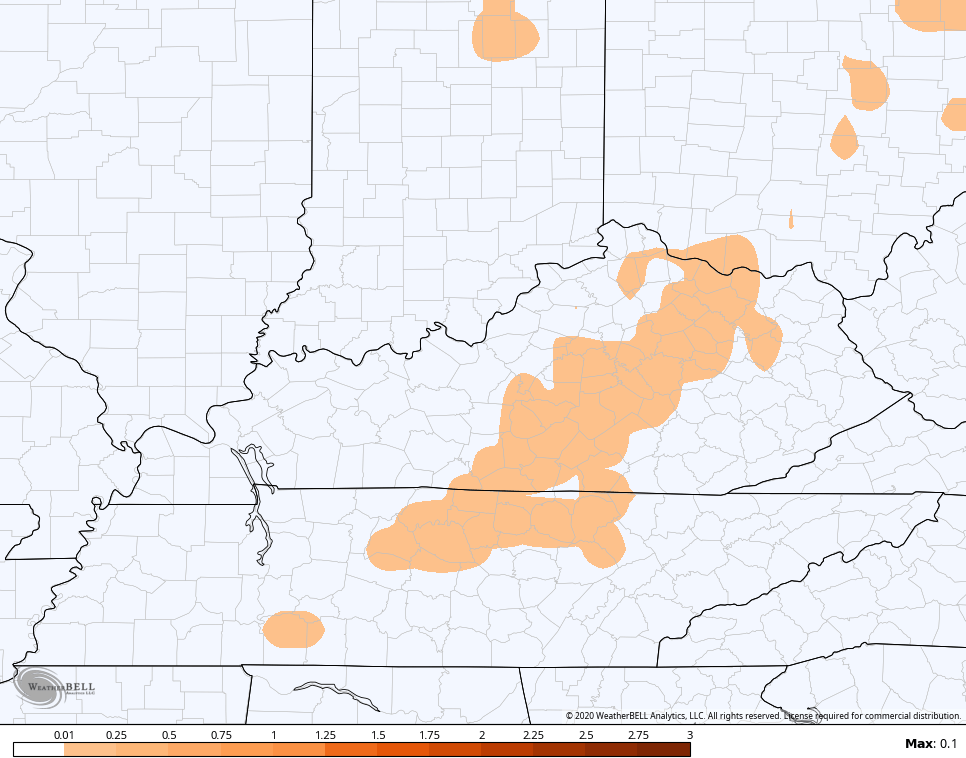
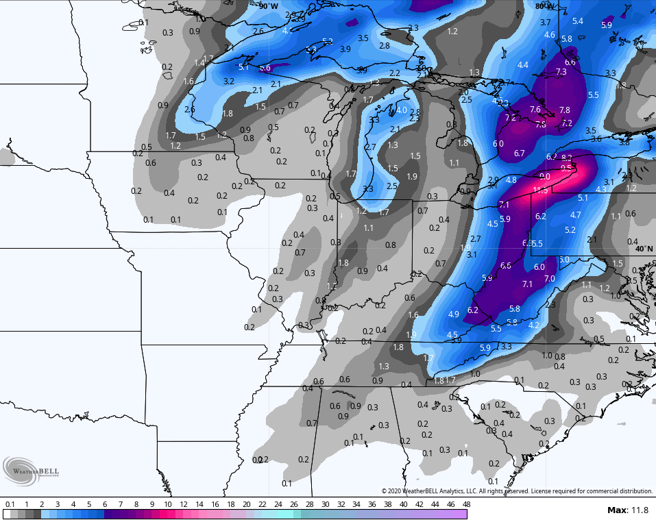
Good Thursday and Merry Christmas Eve. A developing winter storm continues to take shape and confidence is increasing for several inches of snow to fall across the eastern half of the state. Current trends are for a farther west and stronger storm system, bringing accumulating snows back into central Kentucky. This is the first of a few snow makers through Christmas Day.
Here are a few of my thoughts:
- This is likely a significant snowstorm across eastern Kentucky into areas of Ohio and West Virginia.
- The arctic front slams eastward this morning with a narrow ribbon of snow and mixed precipitation right behind it in central Kentucky. This won’t look very impressive until we get into late morning or afternoon.
- This is when the front is into eastern Kentucky and that’s when the low pressure develops along it. This rolls from east Tennessee and up the eastern Mountains of West Virginia.
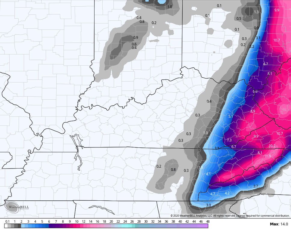
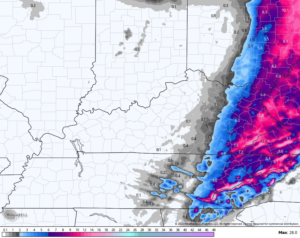
- Moderate to heavy snow will rapidly increase this afternoon and evening across eastern Kentucky. This may actually back west with the edges getting into central Kentucky for a time.
- Snowfall rates across far eastern Kentucky may peak at 1″ per hour during the evening.
- Winds will be gusty and some blowing snow will also be possible.
- As the snow band slowly pulls out of eastern Kentucky overnight, snow showers and snow squalls will be coming in behind it across central Kentucky. These squalls can put down hit and run accumulations and significantly reduce visibilities.
- Another round of light snow will be around into Christmas Day.
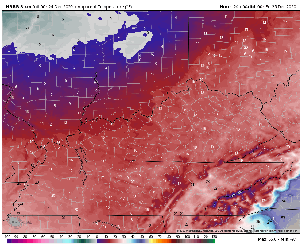
- Wind chills will be near zero at times tonight through Christmas Day.
My latest Call For Snowfall pushes everything farther west and increases totals in the east…
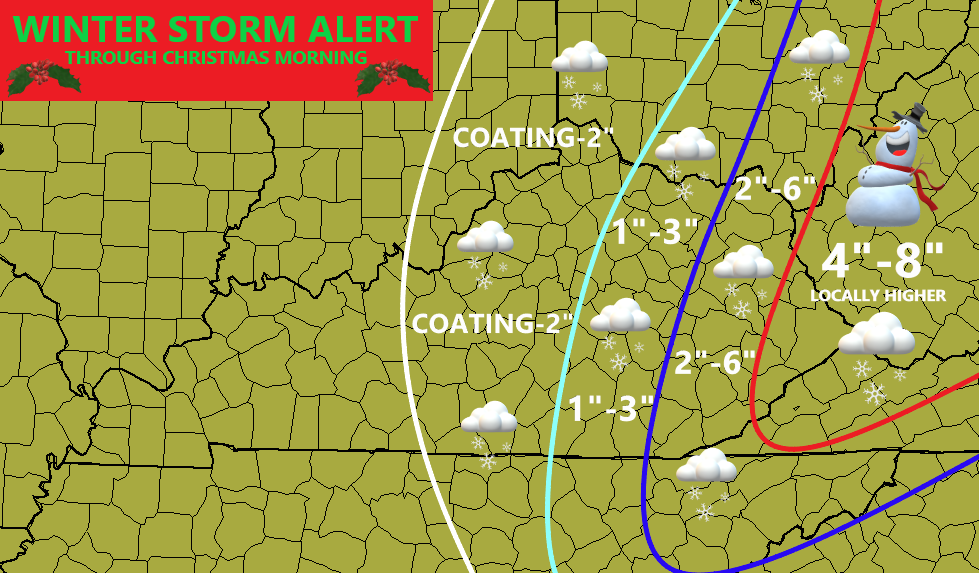
I will get a Final Call For Snowfall out before noon today. The westward trend may continue with this.
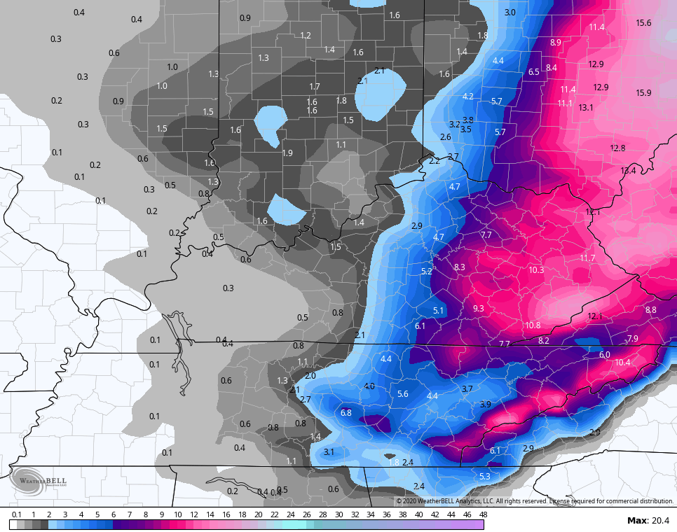
In terms of the forecast models, the Canadian Models haven’t budged in being the farthest west and snowiest.
Short Range Canadian…
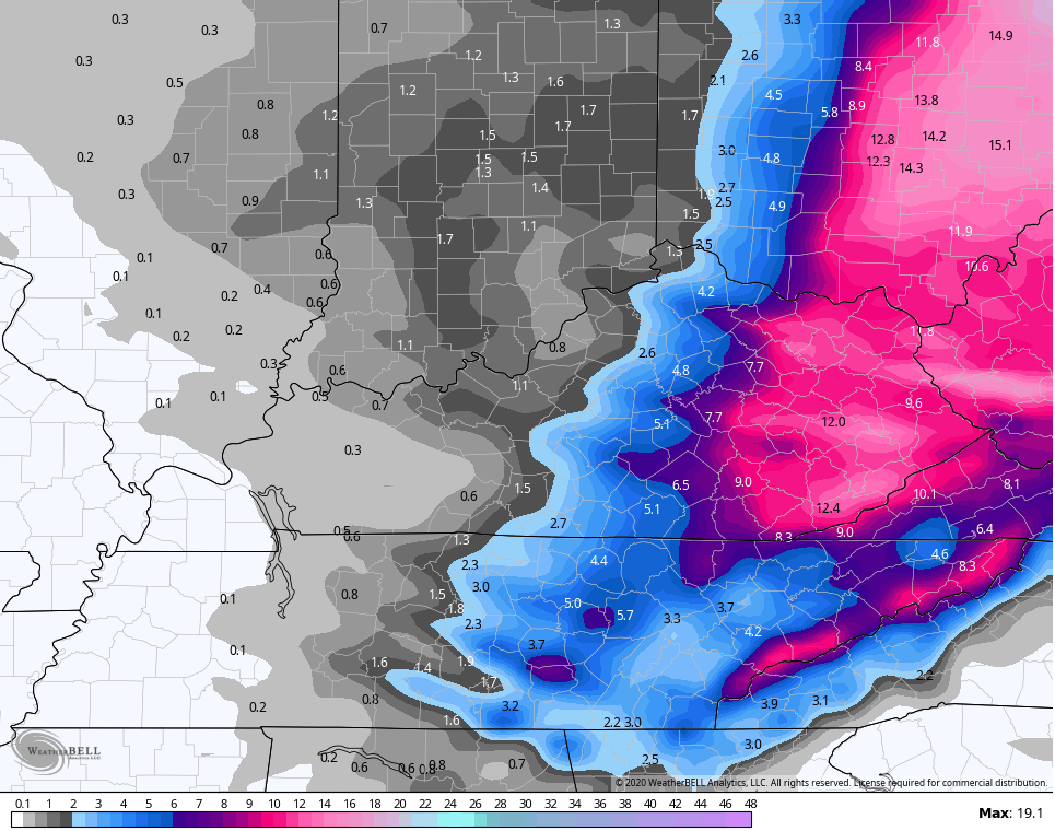
Canadian…
The EURO had gone way east earlier, but the last run adjusted back west by a good margin…

The GFS is also coming back to the west after a trip eastward earlier in the day…
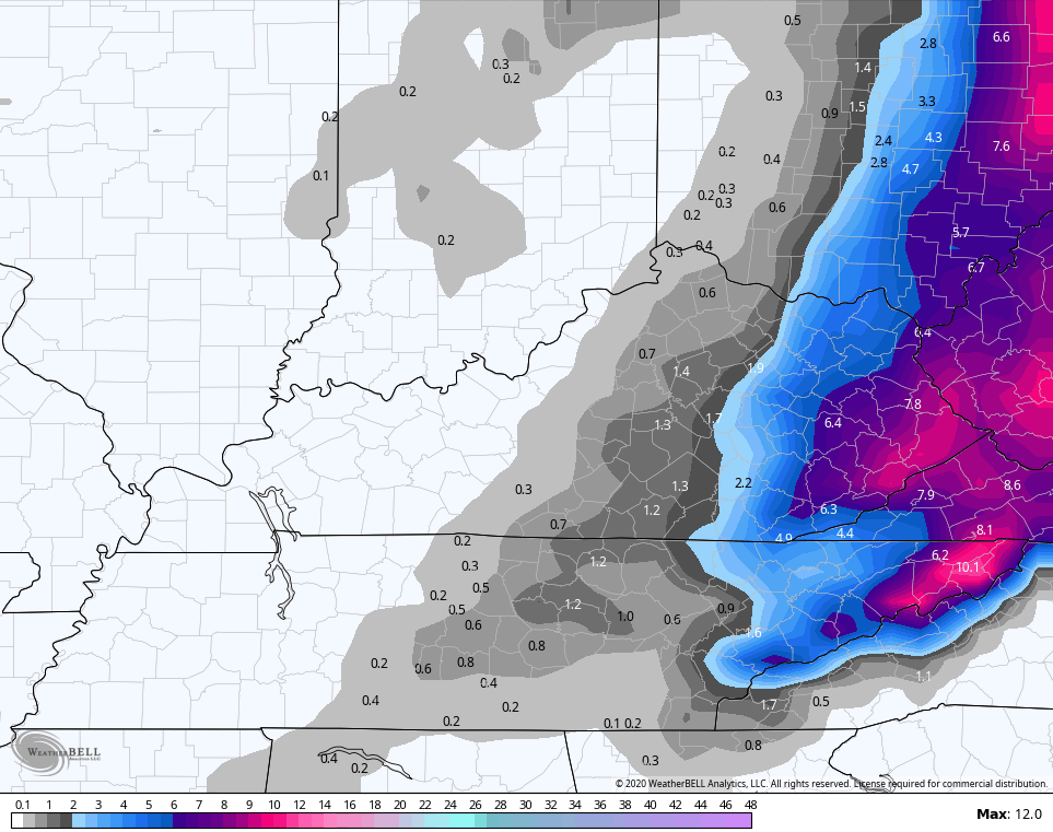
The totals are down a bit because the model sees more of a mix…
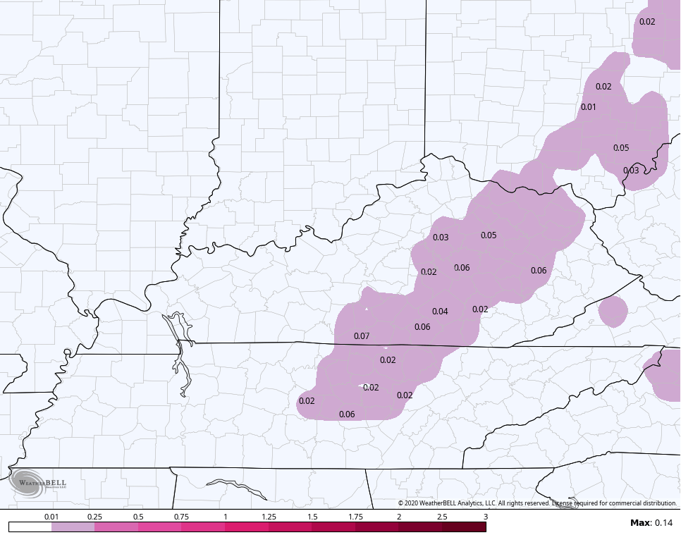
SLEET
FREEZING RAIN
The NAM has struggled, but it’s coming back west as well…
 The Hi Res NAM is coming back as well…
Again, the American Models have struggled most with this in recent runs.
The average of the ENSEMBLES are also sending out a strong signal and show a big increase in just one run…
GFS ENSEMBLES (10-1 ratio)
EURO ENSEMBLES (10-1 Ratio)…

I mentioned the wind chills. Check out this run of the HRRR…
I will have updates all day long and will adjust the snow map as needed.
Here are your radars to follow the progression of the day…

Merry Christmas Eve and take care.

Thanks Chris, and MERRY CHRISTMAS EVE to you too. The light rain as now past to our East and the temperatures are beginning to tumble.
East Kentucky get your sleds and pans ready for Christmas Day. Also looks like there will be enough good packing snow to build a Snowman. I was always told if you build a Snowman on Christmas Day you will have good luck.
I’m still holding out for an inch or less for my county of Taylor.
Chris is right it doesn’t look “impressive” at this moment in time.
It never really did, unless focus on the models that look the snowiest (and are usually wrong). A met last night at around 8PM showed a model with a lot of snow and folks are running with that today. I’ve had texts asking about it and said maybe for the far east, but that was one of many models. Cherry picking is only good if picking cherries.
Lol @BubbaG that’s so true .
Happy Christmas Eve everyone!
I’m excited for the snow but not for that windchill.
Thanks Chris for keeping us updated.
Yesterday’s high of 58 degrees at Chicago’s O’Hare Airport just missed the all-time record high temp for the date of 62 degrees set in 1982.
It’s a freezing cold Christmas Eve morning though, with a temp of 11 degrees here in the SW suburbs with a wind chill of 8 degrees below zero.
It’s pretty impressive to get that cold with no snow on the ground, but at least there’s a few festive flakes falling.
Looks like models have pretty much agreed on a 2-8 inch snow depending on where you live in EKY.Just according to where the heaviest banding sets up.Ratios should be a lot higher than 10:1.Models are still barely ticking west so if you’re on the line there still hope.Hope everyone gets some snow.
Absolutely nothing here in Nelson County. 🙁
Has not been a good snow season for the I-65 and westward counties.
Here in NW PENNSYLVANIA we are expecting 18″ of snow.
temp. 48 in Johnson Co. Mesonet 33 in Madison Co. rain has stopped here snow will start later
Looks like Eastern Kentucky has best chance at seeing A White Christmas.
Here on Fleming/ Rowan line still just getting a steady cold rain.
Still just a cold steady rain on Fleming/ Rowan line ..it will take a lot to overcome the extremely wet ground & puddles of water
As of 10:30 pm CST, we are snow-less in Warren County.
#BahHumbug