Good afternoon and Merry Christmas Eve. Snow will quickly take control across the eastern half of the state as low pressure develops along our arctic front. This is going to drop several inches of snow in the east with lighter amounts the farther west you get. In addition to the actual storm in the east, snow showers ands squalls may cause problems in central and parts of western Kentucky.
As of early afternoon, Winter Storm Warnings and Winter Weather Advisories are out for much of central and eastern Kentucky…
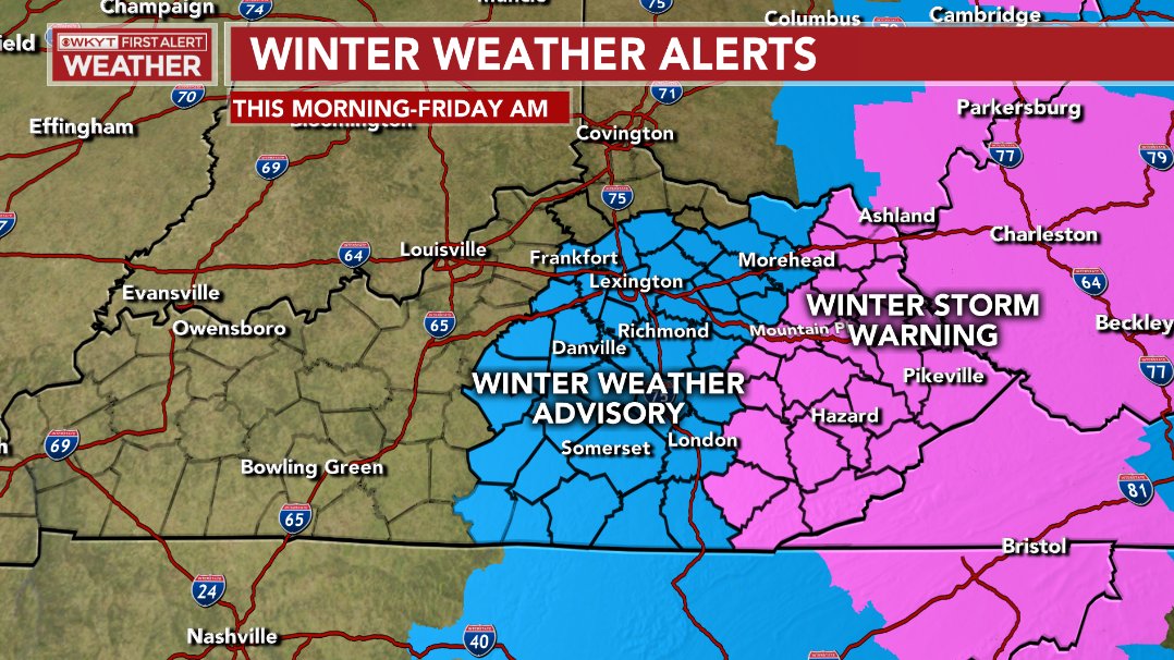
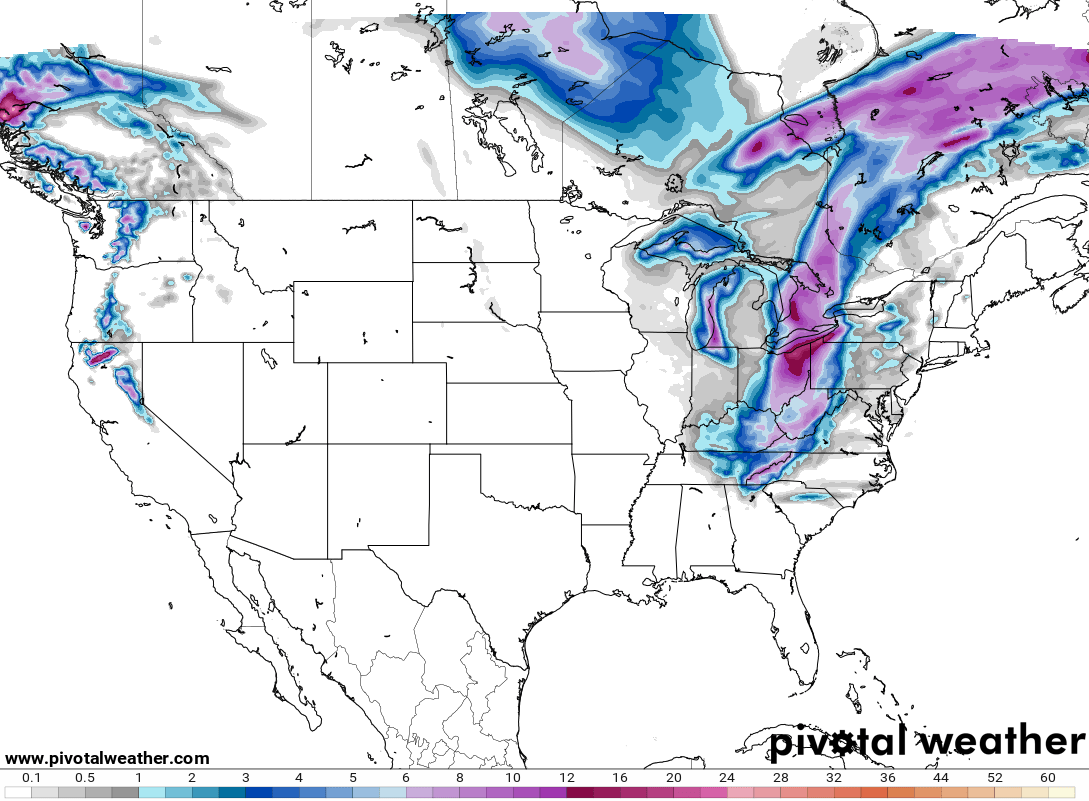
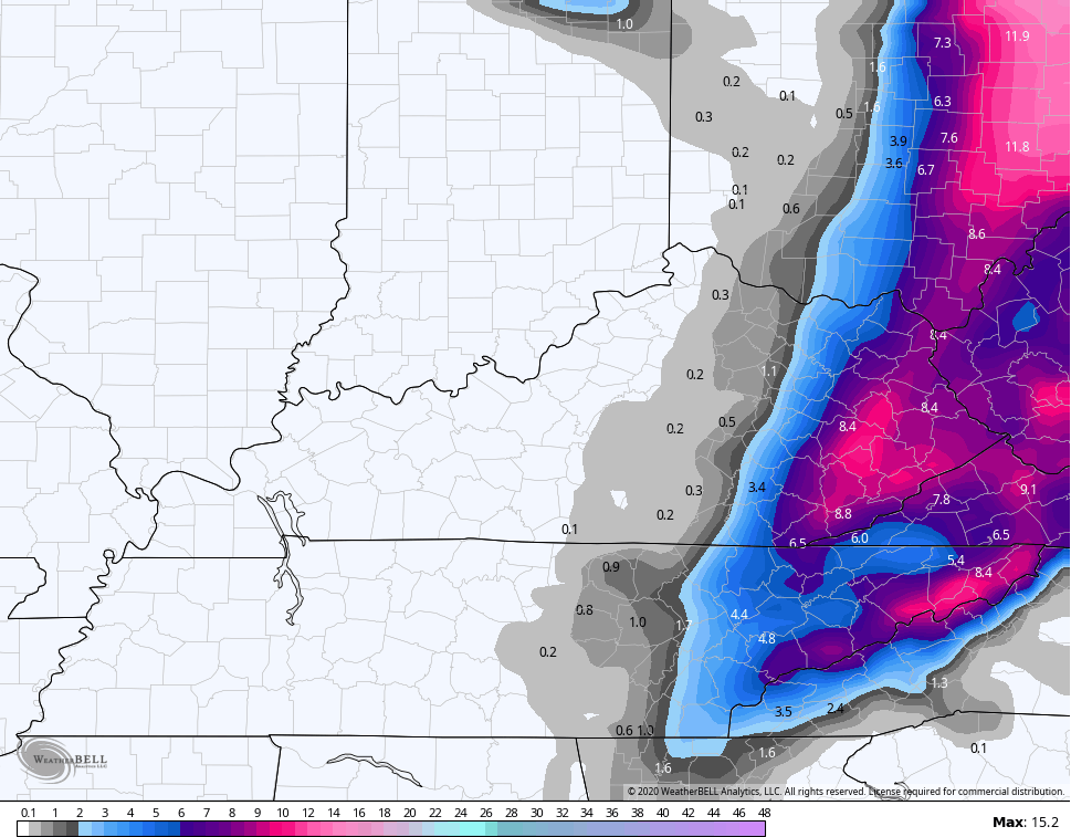
How amazing is it to see THAT map on Christmas Eve?
An icy glaze and flash freeze are showing up in the transition zone from rain to snow. This will add an additional layer of travel troubles as the day wears on and temps continue to crash through the 20s.
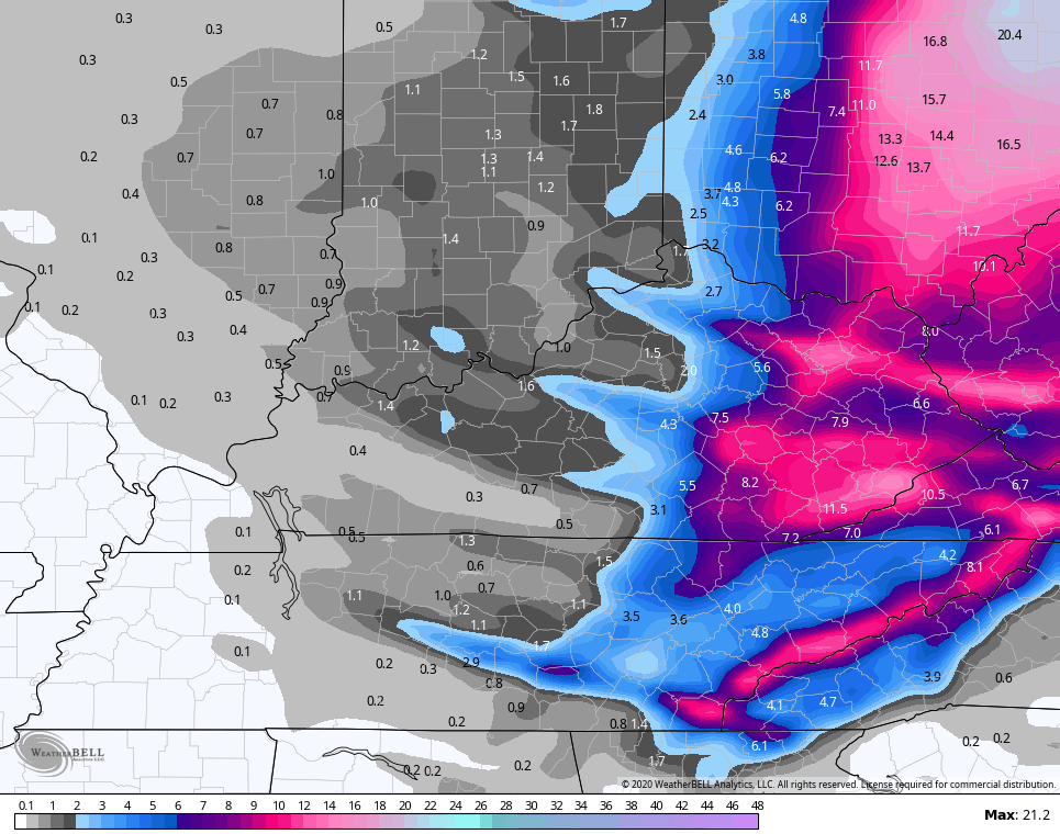
The snow shield engulfs eastern Kentucky this afternoon and evening and will even spread back west for a time into the early evening. At the same time, snow squalls will develop in a west to east fashion and can put down a quick inch or so of snow and reduce visibilities. Another round of light snow then shows up Christmas Day.
I’m going to ride with my current call as the Last Call For Snowfall…
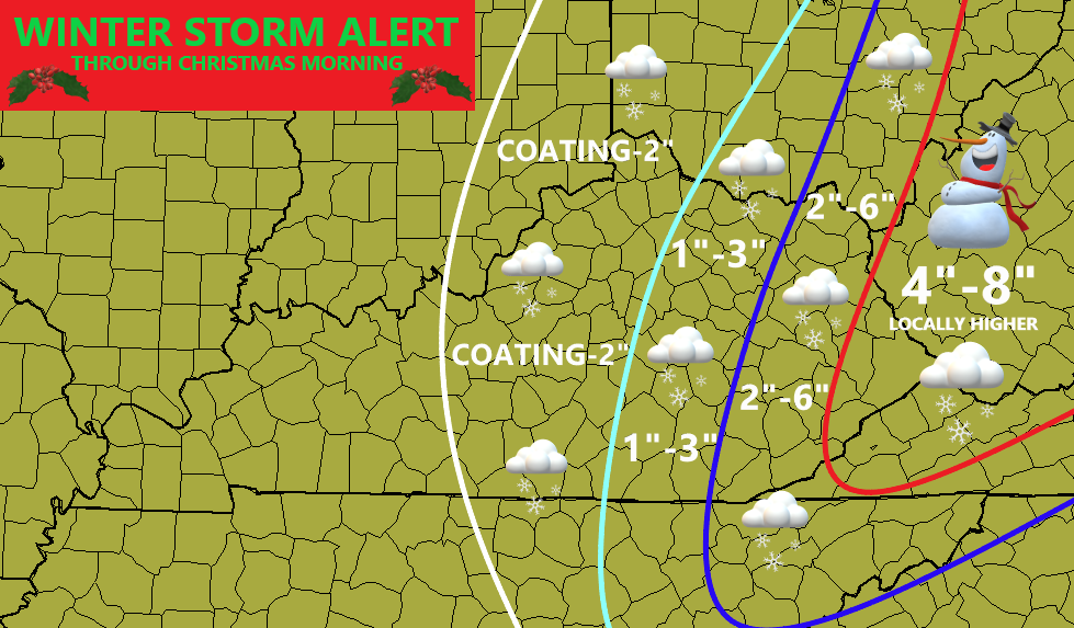
I could push that coating-2″ line a bit west to account for the snow squalls developing.
The Weather Prediction Center has the Slight Risk for 4″+ snows back into central Kentucky with a Moderate to High Risk in the east…
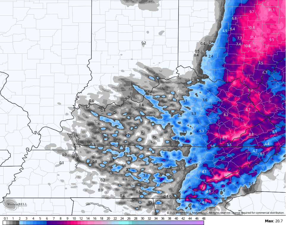
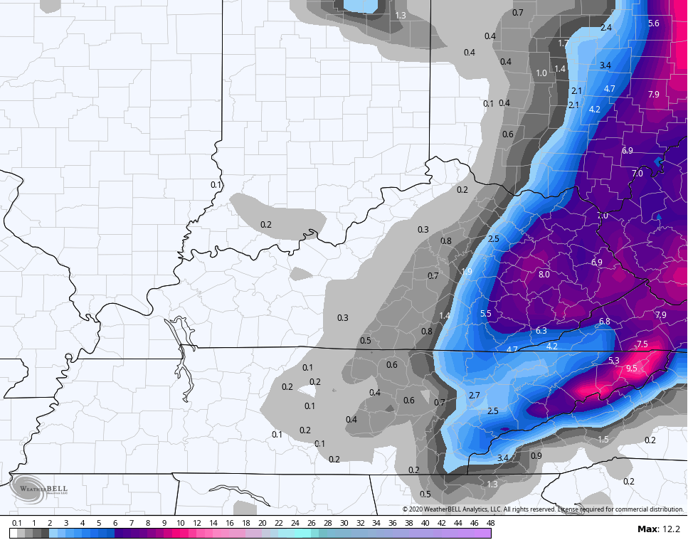
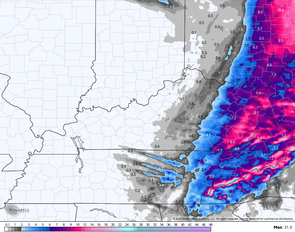
In terms of the forecast models, let’s start with the short range Hi Res Models and go from there. The HRRR is showing a big hit in eastern Kentucky and also shows those snow squalls in central Kentucky doing some serious work…
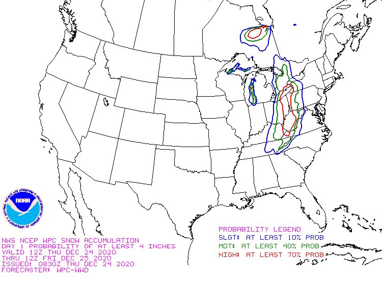
That map only goes through 5am Christmas Morning.
The RAP also shows a big hit for eastern Kentucky and you can clearly see the snow bands into central Kentucky…
The Canadian Models continue to do what they’ve been doing for the past few days…
Canadian

Short Range Canadian
The EURO is west of earlier runs…

The American Models really really struggled over the past few days, but seem to be getting in line with everything else. They’re still not seeing the squall action very well, though…
GFS
HI RES NAM
NAM
Wind chills during this time continue to drop and will be near zero tonight into Christmas Day. Ouch!
I’m off work today, but will be updating things here on KWC. Here are your radars to track the band of snow across eastern Kentucky and the squalls developing for the rest of the region…

Merry Christmas Eve and take care.

Looks like the forecast is starting to come together.
moderate snow east 80 in manchester.
LOL..What a weenier run on the Euro after New year’s.If you like feet of snow this one’s for you.Of course ain’t gonna happen but that time period may have to be watched.
Does it cover the majority of the state or only east of I-75?Lol
Lol.Showing Tennessee with the heaviest with southern ky and EKY fair amount.Just goes out to 240 so probably more.
https://www.pivotalweather.com/model.php?rh=2020122412&fh=240&dpdt=&mc=&r=us_ov&p=sn10_acc&m=ecmwf_full
Looking real nice in Richmond.
Looked great as we left church in Richmond around 6 tonight!
Plenty of clouds, cold, and wind here in NKY, but only a few flakes in the air 🙁
Nonetheless, a very Merry Christmas to all the KWC family! 🙂
WOW ! Snowstorm is really coming together. Chris did a great job predicting where the most snow would fall.
Not even a flake of snow here in Taylor county.
It’s even snowing in Atlanta, Georgia.
Looking forward to all the Christmas Snow photos on tweets.
snowing in Johnson Co.
Here in south-central Indiana we have had a few flurries today, but have received nothing more than a very light dusting. I’m jealous of anyone in eastern Kentucky right now, but maybe I can get a snowstorm here in the next couple weeks. Anyways Merry Christmas everyone and stay safe out there tonight and tomorrow, I’m sure the roads are getting rough.
ECL2002, Are you old enough to remember Christmas Eve 1969 ?
Nope not even close, I wish I was I’m guessing it was a big one?
We had over a foot of Snow on Christmas Eve 1969 and then again on New Years Eve.
1969-70 was the snowiest Winter I’ve have seen in my life.
Merry Christmas to you and your Family.
We have a dusting at my home in Burgin. I was sure hoping for a couple inches. Merry Christmas
Roads are already impassable here. Around 2 inches on the ground so far.
Roads are already impa$$able here. Around 2 inches of snow on the ground so far.
Taylor county is right on the western edge of the Snowstorm, but there is energy to our west which may enhance the Snowfall totals in Eastern Kentucky.
Guess I’ll eat my words. Said this would be another dud and I was wrong. About 5 inches here and still snowing
Troy, I think this snowstorm overachieved in East Kentucky. You got a Christmas Surprise. Very rare for Snow to fall on Christmas Eve almost every where now days. Merry Christmas to you and your Family.
Shame the whole state of KY didn’t get what’s eastern. KY getting.. But life goes on and Merry Christmas to all!
Winterlover, Yeah I know what you mean. Snowstorms now days are not the three to four state block busters we use to get forty to fifty years ago.
I’m writing this on Christmas Morning and I have an inch of Snow on the ground.
I hope you got the same.
Very pleased with how the snow has fallen in Richmond.