Good Sunday, everybody. A weak cold front is dropping into the region tonight and it’s bringing another big increase in winds. That’s the beginning of a very active New Year’s week that will feature a big time storm system just as we say goodbye to 2020 and hello to 2021.
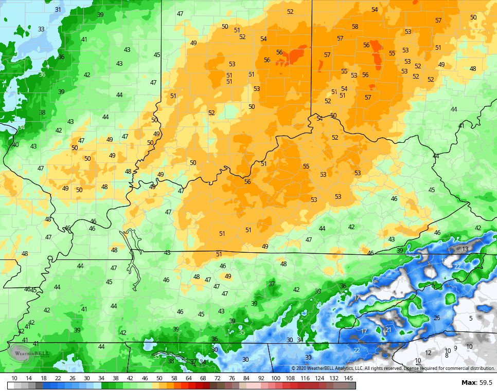
Temps ahead of our weak front will surge today, so some ugly snowmen and women will start to show up.
The front drops in tonight with just the chance for a late shower that may have some flakes mixing in. Winds just ahead of this front will crank to 40mph-50mph at times, especially across the northern half of the state. The Hi Res NAM has gusts greater than 50mph…
Given the thawing ground, it wouldn’t take much wind to knock a few trees down.
Colder air comes back in behind this for Monday as our focus quickly turns toward the next storm. This looks to arrive late Wednesday into New Year’s Eve and it looks to be another high impact system around here.
A few thoughts:
- Low pressure works toward the Great Lakes and drags a cold front in here. That front slows down as low pressure develops along it. Exactly where this happens isn’t as clear cut to me as the Christmas Eve storm. I said that would happen along the Appalachian Mountains a week away.
- This may also be a slower and stronger low pressure wherever it decides to track.
- This could bring several different types of weather hazards in here. Heavy rain, high winds, a mix and freezing rain and snow.
- How much you get of each will be determined by the track of the low.
- Regardless, this looks like a big ticket item and seems appropriate to have this kind of storm to end this crazy year.
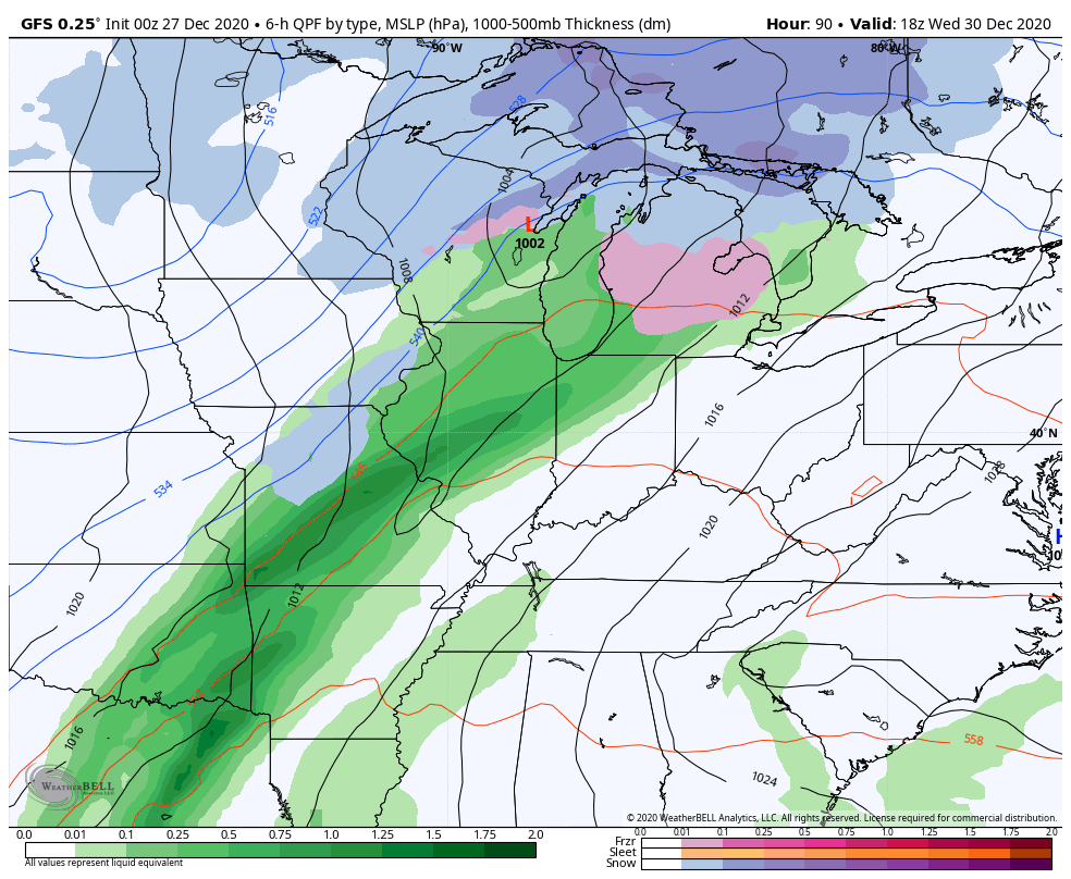
The GFS has a very ugly look with heavy rain and freezing rain…
The Canadian is a little farther west than the GFS…
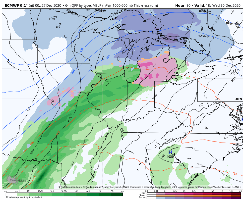
 The EURO is the most wrapped up and farther west, but that’s likely the bias of the model coming into play once again…
Remember, there were runs of the EURO that took the Christmas Eve low from St. Louis to Cleveland. It was actually up the spine of the Appalachian Mountains.
I will have updates later today, so check back. Have a good one and take care.

Wow Chris, Ugly Snowmen and Snow Women showing up, you may get into trouble over that Chris. LOL
Those early model runs suggest that something in the way of a major Snow or Ice Storm may be brewing.
Please let it be Snow !
The safe bet is mainly rain with a switchover to snow near the end.(Wed-Fri)
Look like models are pretty much showing a cutter.Guess we’ll know in a few days.
I’m sure a terrible ice storm would be the perfect way to end this crazy year.
Well, for Bardstown, anyway. If the storm is big enough, and both snow & ice are on the table, the snow part will skirt us by it’s usual 12-15 mile radius! LOL! 😀
We had a nice half inch snow in Bardstown for Christmas!
Haha Shaak …so freaking true! But I’m.puttinv in my prayers now for no ice!! Don’t want to go almost 2 weeks w/ out power again
We were only out for a week fortunately, but I would rather not do that again.
We lost power from Dec. 21/22-early Christmas Day with the Dec. ’04 ice storm. For whatever reason, we didn’t lose power, not nary a flicker, with the ’09 storm. Cable was out for 11 days, though, because the out-of-state idgits they sent out to fix it said that the wire hanging into my backyard from the neighbors’ behind us was a PHONE LINE….?! I told them they needed to check, it was NOT a phone wire, and they acted like I was a typical stupid woman. Finally, on the 11th day w/o it, I called, Bardstown Cable guy comes out, looked at the wire and shimmied up the pole with it and we had TV in less than 2 minutes. Duh…
Yep, like the 2009 Ice Storm. More than 15 days without power.
My property was an expensive mess !