Good afternoon, everyone. It’s a good looking day in the bluegrass state, but the focus is on some ugly as we get set to end 2020 and kick off the new year. A three pronged storm system is on the way and looks to bring a lot of rain, wind, a few strong thunderstorms and some winter weather.
The first surge of heavy rain and gusty winds arrive Wednesday night as a cold front drops in from the northwest. This front has a blast of cold behind it that settles into the region for the last day of the year. I’ve been focusing on the potential for some winter weather across parts of the north and west, especially Thursday morning…
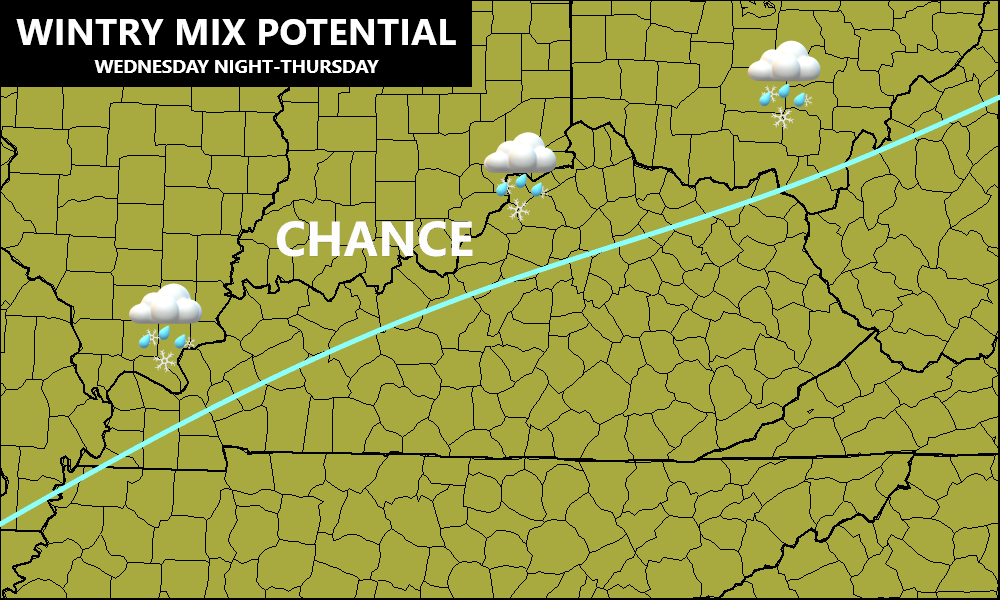
The majority of the forecast models are now on board with that idea. The freezing rain threat continues to be of particular concern as it shows up stronger than the other winter weather variables.
The EURO continues to have more of a snow signal behind the front…

It also has some freezing rain…

The GFS went from showing ZERO winter weather to now showing some sleet, snow and freezing rain behind this front…
SNOW

SLEET

FREEZING RAIN

The NAM is also starting to see the freezing rain potential…

The Canadian isn’t as crazy with the freezing rain as earlier runs and now looks more realistic…

So, if you live in the area I’ve outlined for some winter weather early Thursday, pay close attention to how this plays out. Just a little bit of freezing rain can cause big issues.
From here, a powerful low pressure then lifts northward through the Mississippi Valley New Year’s Eve and New Year’s Day. This will bring the potential for high winds and even a few strong thunderstorms. It’s another big rain maker that may also cause local high water issues. Here’s the area I’ve already outlined…

The models continue to show hefty rainfall amounts through Friday night…
GFS

CANADIAN

NAM

EURO

Another system will follow this up by Saturday night and Sunday with a borderline winter event.
The evolution of the pattern continues toward massive blocking developing over Greenland and the Arctic, allowing for a deepening trough into our region during the second week of January…

I’ll hook you up with another update this evening. Have a good one and take care.

There may be hope for us winter wx/snow lovers yet! 🙂
The presence of substantial blocking makes me wonder whether the current La Niǹa was weakening, but looking at the current SST anomalies would lead me to believe that it is strengthening! When you consider the current ENSO plus the mega high & low pressure systems that Chris pointed out in the previous update, we’re experiencing global weather conditions that are somewhere between wacky and absurd. It’s no wonder that forecast models have become more unreliable.
JoeD, You are spot on. Great comment and information. I think we can put this Winter to bed. With La Nina getting stronger you can write off any snowstorms for our area of the state.
We were lucky to get that 1 inch of Snow on Christmas Day.
For December I measured 2.5 inches of Snow with a frigid low of 10 degrees F.
I’m hoping the polar vortex disruption that is growing more and more likely with each passing day will deliver a couple nice snow events to the region during the second half of January, but with our luck it will be heavy rain followed by arctic cold and a few flurries.
The thing is, even if La Niǹa strengthens, the other forces which govern our weather are changing proportionally. In essence, we are seeing a magnifi out chaos
The thing is, even if La Niǹa strengthens, the other forces which govern our weather are changing proportionally. In essence, we are seeing a magnification of chaos, and forecast algorithms abhor chaos! Nothing is off the table!
Thanks Chris for the update. Ugly and down right depressing weather to start off the New Year.
An awful lot of Ice potential on those models which is too close for comfort.
It took almost until the end of the year for the first Winter Weather Advisory of the season to be issued for the Chicago Metro area. It’s in effect until 9 AM Wednesday. 3 to 5 inches of snow is expected north and west of Chicago, with 2 to 4 inches from the city on south before changing to sleet and freezing rain after midnight and then to rain by morning as temps rise above freezing.
It’s snowing at a pretty good rate over the whole Chicago area now. Rush hour is going to really be a mess.
It’ll be interesting to see how much of the snow melts when temps go above freezing tomorrow and changes to rain.
We’re finally going to catch up to Schroeder and the rest of you guys in Kentucky with the snowfall. The less than an inch we’ve gotten so far this winter is ridiculous!
Glad to see your finally getting some snow Mike, you’ll probably have more than me for the season by tomorrow morning, that’s not saying much though because I have only measured an 1.5” total here near Bloomington, IN.
Formally From Kentucky, really gave an impressive snowfall total for December 2020 at 68 inches in NW Pennsylvania.
If I was younger I would relocate to the Snow Belt. More exciting Winters.
I’m stuck here and will have to except a “little crappy Winter.
A depress Schroeder.
If the above blocking does occur and keeps the zonal pattern moving Ky will be inline for winter weather events. Albeit it could be rain to snow, mix to snow, rain to mix to snow to rain. Or just a plain oh Old Skool thumping that RoLo and BubbaG talked of in the past, would be on the table. Don’t you just love Kentucky winters. I like our chances better this season as to what we had the past two or three. Oh is forgot to mention the dreaded Ice word.