Good Monday and welcome to the month of February. The brand spanking new month is kicking off with rounds of snow across much of the Commonwealth as we put some of the white stuff on the ground. This is part of a pattern that’s threatening to go to the extreme this weekend into early next week as arctic air meets an active storm track.
We have two main rounds of snow out there today. The first one is working through this morning and is putting down accumulations that can cause travel conditions to become slick. The snow becomes lighter into the afternoon and becomes more concentrated on central and eastern Kentucky. This is when another round of pretty good snows develop to our north and northeast and works back in here. Again, this snow is coming in waves through early Tuesday, so be patient if you don’t have much early today.
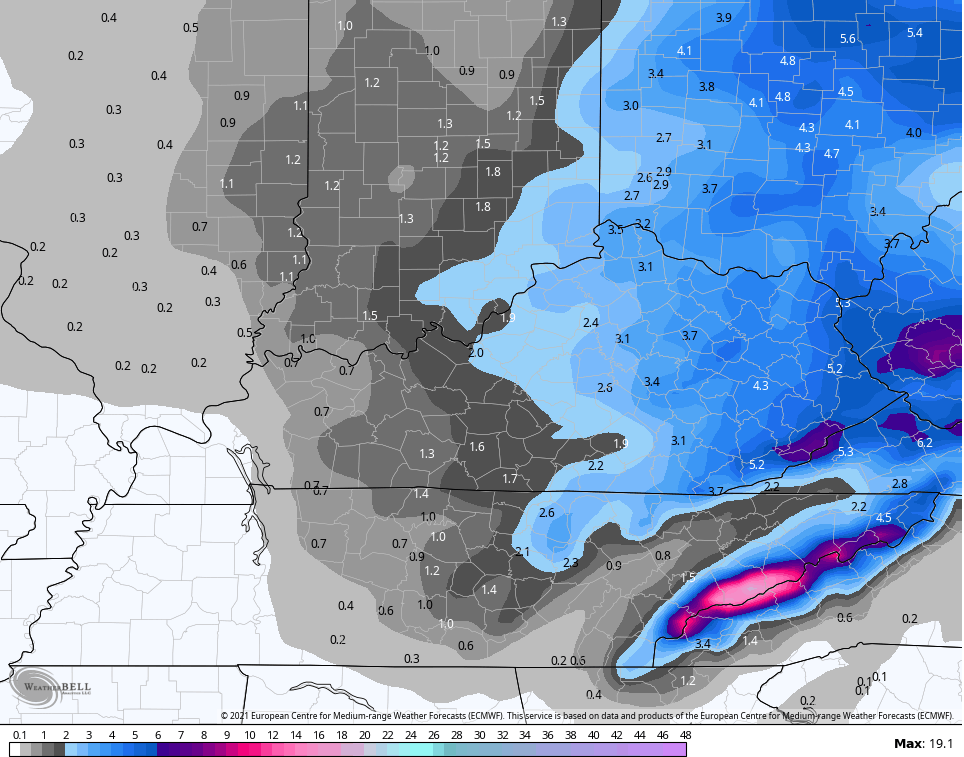
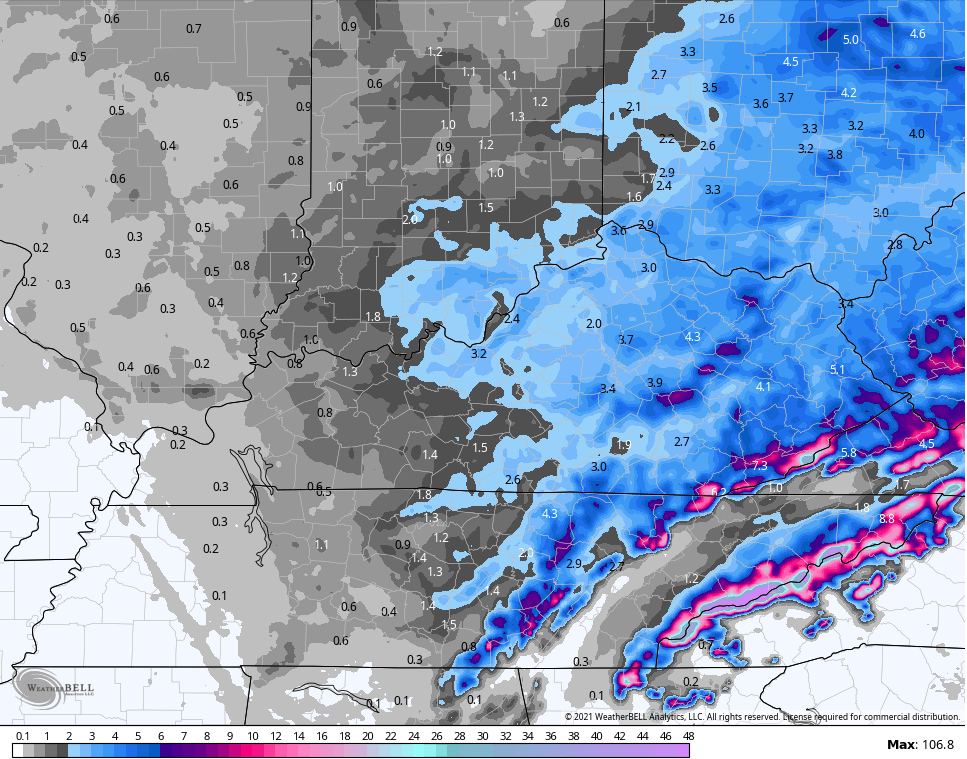
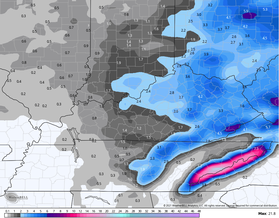
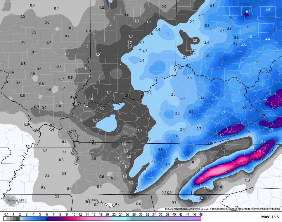
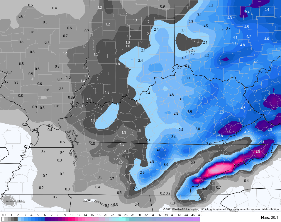
Total snowfall through from last night through Tuesday on the models is similar to the forecast we put out here…
EURO
Hi Res NAM
NAM
Short Range Canadian
Canadian
GFS
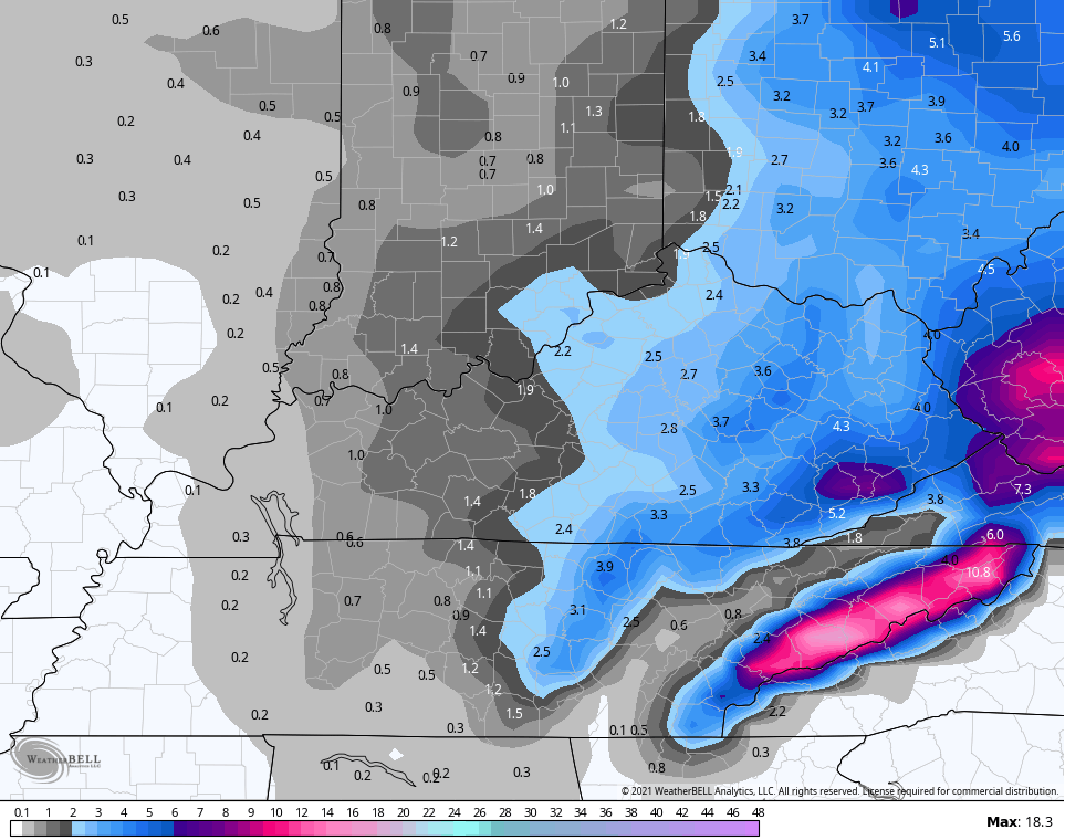
No, you’re not waking up to those totals and may never measure the high ends at any one time, but you get the idea. These are total amounts through tomorrow. Those maps sum up the winter, so far, with areas of central and eastern Kentucky with much above normal snows, while the west is well below normal.
Here are your radars to follow along…

A strong northwest flow has a Lake Michigan connection Tuesday night into early Wednesday. That may keep a few snow showers and flurries going…

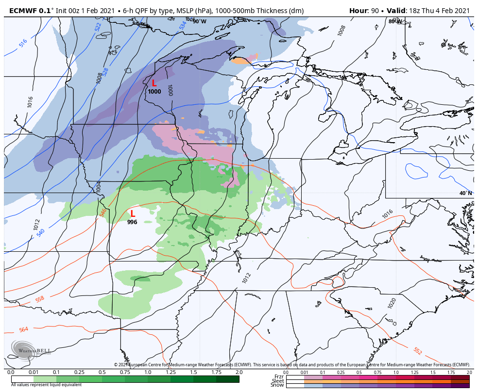
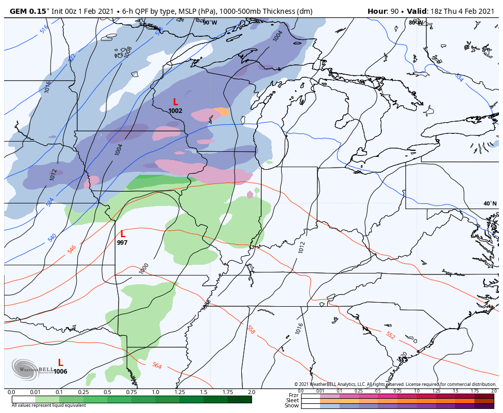
A strong cold front works in here Thursday night with a brief spike in temps ahead of it and a big temp crash behind it. Rain ends as snow with the main focus being on the system behind it next weekend. The models will go back and forth between a huge winter storm and a simple arctic frontal passage with some snow. I’m not to the point I can tell which is correct. Arctic air will pour in behind that and if there’s snow on the ground, look out.
The EURO doesn’t have the big storm from the last run, but has snow with an arctic front and bitterly cold air…
The Canadian is showing this setup well and also shows a few more systems behind that early next week…
You’re going to start hearing a lot about the Polar Vortex again because the models all prog this thing into the Great Lakes this weekend and early next week. Check it out…
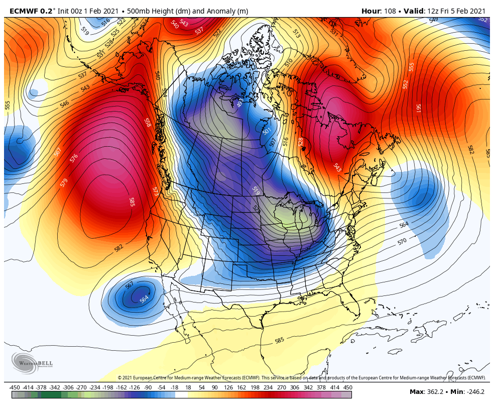
All that blocking I’ve talked and talked about is finally starting to do some work and , unfortunately, it means severe cold air invades much of the country. The coldest temp anomalies in the entire northern hemisphere are forecast to be right on top of us early next week…
Here’s hoping this changes and doesn’t pan out or even come close. Not just around here, but for the country as a whole. That would create a lot of hardship if it happens.
I will have your normal updates later today. Make it a good one and take care.

A nice snow band east of Paducah.
The extreme cold will make people want to forget about wishing for winter snow. Many people will start wishing for an early spring.
already happening
second that…been wishing that for a month, though that hasn’t helped
Here is the final recap of the major snowstorm that slammed the Chicago area late Saturday afternoon through Sunday evening. Chicago’s O’Hare Airport received a total of 10.8 inches of snow, which is the highest amount of snow in a single storm there since November 20-21, 2015. The NWS office in Romeoville in the SW suburbs received the highest total in the area, 12.9 inches.
http://weather.gov/lot/2021jan3031_snow
Thanks Chris, Great blog this morning. I agree with you, we don’t need that Arctic Vortex, but it’s been a while since we seen that weather type.
Well the ground is white this morning with about a half inch of Snow. Enough for me, but I know these Kids would want a lot more to go sledding and building Snowmen.
We are well below normal on Snowfall going on six years now in my county of Taylor. I think they (NWS) will eventually reduce the average Snowfall for my area (thirteen inches.) to less than seven inches ?
Radar looking kind of puny.Really wouldn’t expecting much when parts of Virginia and north have been snowing since yesterday with the first system and have received 3 or less inches.Just no good rates I guess.
Seems the best bet is some snow with cold arctic air. Will be surprised if CB starts leaning towards a big snow storm, unless for fringe areas of the state. North and east of us are getting their snow shovel workouts this winter.
If the Arctic air I hope it bust the dome here in western, ky and get some snow
Euro sure is interesting.Storm this weekend with another on it’s heels.Also very cold.We’re in the bullseye so ain’t happening.
You’re probably right about that.
My snow here in Pikeville has wimped out too but that happens out here under the snow dome hahaha but like Chris said they would be waves not all at once so maybe tonight.