Good afternoon, everyone. Let’s begin with a Winter Storm THREAT for the entire region Tuesday night through Friday morning. This is for the potential of significant amounts of freezing rain, sleet and snow. The overall pattern through next week is likely to be memorable for much of the region.
The first system moving through this evening and early Tuesday continues to target areas of northern/north-central Kentucky with a snowfall. A Winter Weather Advisory is out for this area. This setup may also have a touch of freezing rain on the southern edge of this near the Interstate 64 corridor. I’ll keep the First Call map for now…

I will update that as needed later today.
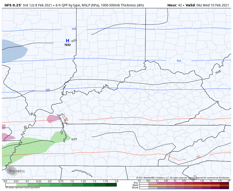
Now to the Winter Storm THREAT. Here’s a preliminary look at how things may shake out…
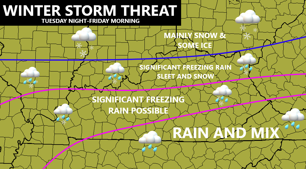
That’s the rough first estimate and I will be updating those lines as the high impact system becomes more clear. The current trend is for a colder solution to play out and that’s exactly how things usually work when arctic air is involved.
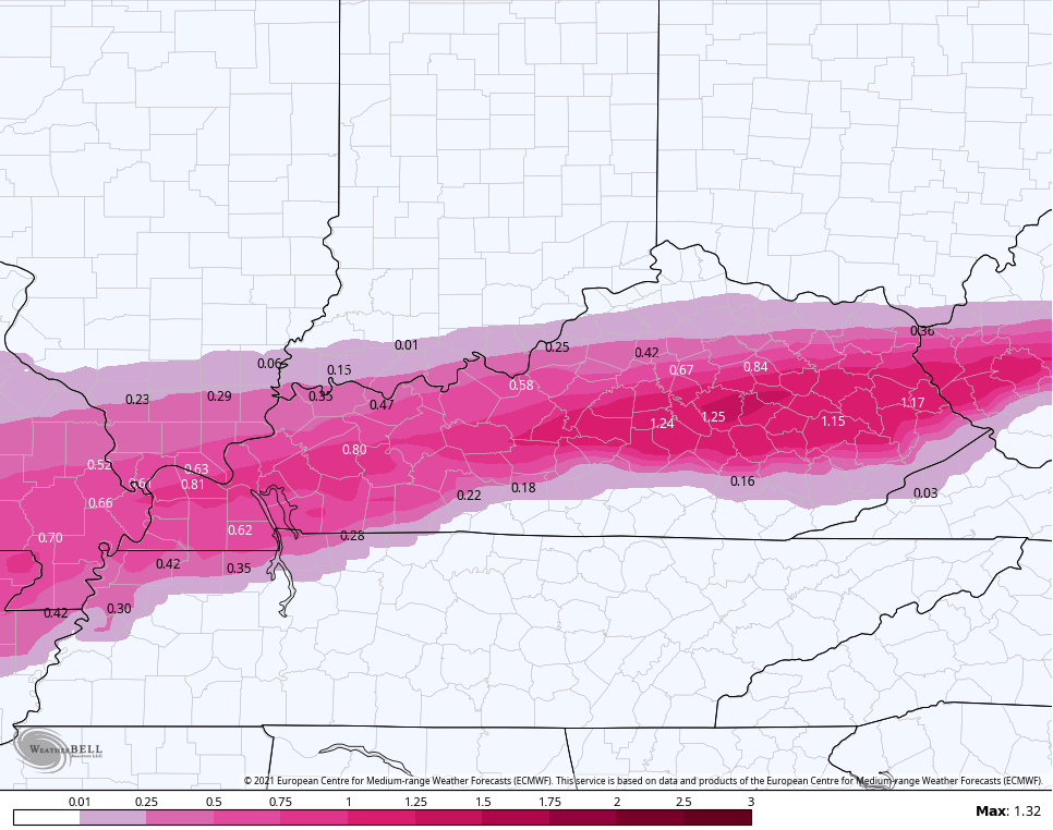
Here’s what the early morning run of the EURO looked like through 7pm Thursday…
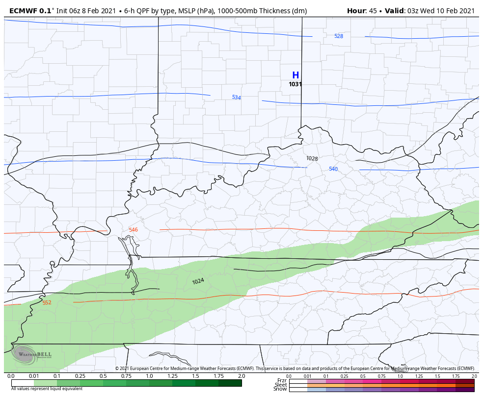
The freezing rain accumulation from that run…
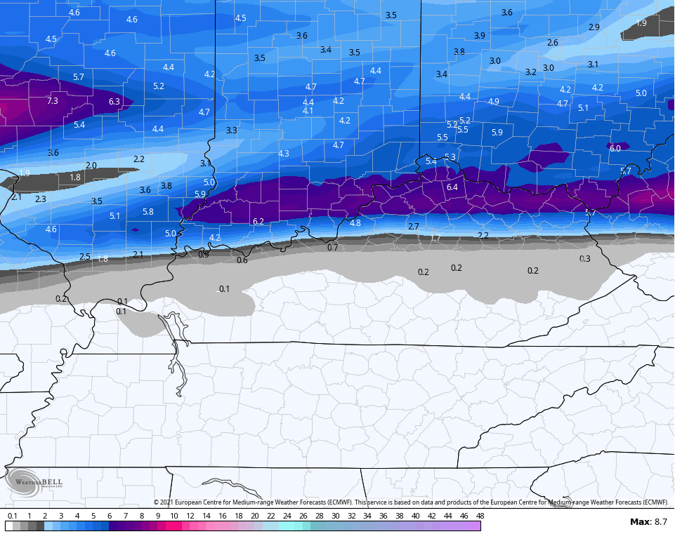
Here’s the snowfall that includes tonight’s action…
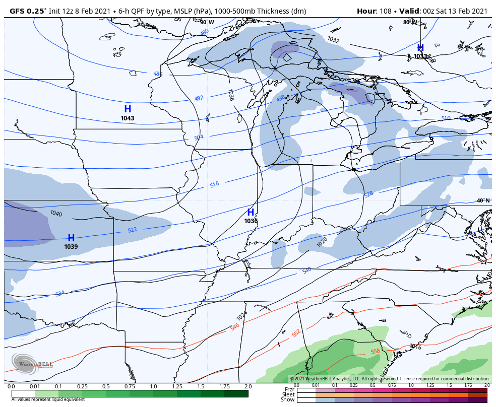
The new GFS is also showing this colder solution pressing the overall impact farther south…
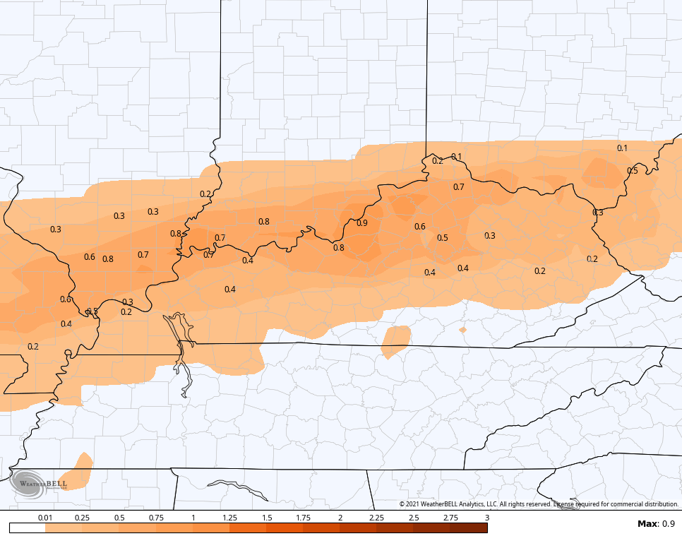
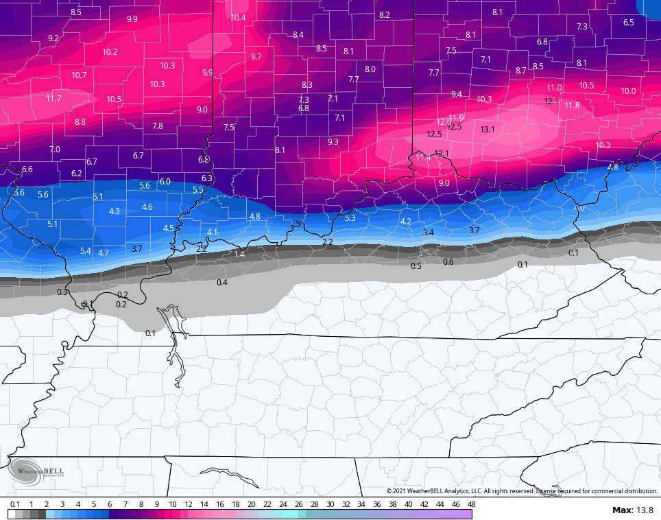
That goes all the way through Friday morning. Here’s how the GFS sees the total amounts of wintry precipitation…
Freezing Rain

Sleet
The snow includes tonight’s action…
Does this whole setup continue to sink farther south as the models get a better handle on just how strong the arctic air is? That’s certainly possible.
After this system, we aren’t even close to being done. Another winter storm may target us this weekend with another possible early next week…
I will have the latest on WKYT-TV starting at 4pm then again on KWC this evening. Here are your tracking toys for the afternoon…


Have a good one and take care.

Why can’t the models be as bad with ice as they are with big snow for KY? A good bust would be nice 🙂
Canadian model is moving south from previous run.Hopefully the other models follow.Hate to see anybody get freezing rain but Tennessee can have it.
https://www.pivotalweather.com/model.php?m=gdps&p=zr_acc&rh=2021020812&fh=108&r=us_ov&dpdt=&mc=
LOL
Looks like from what you posted it may go south! 🙂
Hard to know with ice.Like Chris said model’s have a hard time with shallow cold air.Needs to press south all at once instead of that slow bleeding East.Euro still targeting Ky.UGH.
ummmm no….I live on the TN/KY border and you guys in northern KY can keep it
2003 Lexington ice storm veteran here (2 weeks without power)–NO ICE, PLEASE!!
Winter Weather Advisories are out for the Chicago Metro Area until this evening as light snow is falling throughout the area, which will add to our heavy snowpack. 1 to 3 inches is expected. This will be another powdery snow with the cold temps. It’s around 15 degrees here this afternoon, which is actually warmer than the temps that were only in the single digits on Sunday.
I’ll be following the ice storm threat for Kentucky with great interest, and hoping everyone there stays safe.
We will be little ants for your observational pleasure. LOL
Stay Safe Mike, And don’t Overdo On The Snow Shoveling. My Father Was A Medical Doctor And He Said To Me when I Was Much Younger To Cover My Mouth And Nose When Working Outside In Frigid Weather.
Still Confused As To What My County Of Taylor Will Receive In The Way Of Dangerous And Destructive Ice.
Literally, There Is 100 + Forecast Out For The Week Into The Weekend.
One Of Those Forecast Is Calling For 8 To 17 inches Of Snow Around The Middle Of The Month. ( GFS Model)
Tonight It’s Mainly Light Rain And Tomorrow’s Forecast High Is in The 40’s.
I’m Ready For Anything And I hope all Of You Are Also.
Stay Safe Everyone !
I Know One Thing That Arctic Air Is on the Move South Towards Texas On the Western Side Of The Southeast Ridge. but the longer it stays North and West of Our area the more it will moderate.
A Zonal Flow is Fast Moving Across The Gulf States And That May Help Us On The Amount Of Freezing Rain We May Receive Forecast for Thursday.
I found the above information On The Ventusky Weather Site.
Already let my boss know some models are showing up to 1 inch of ice in my area. My hour commute isn’t happening.
Who really Knows How Much Ice We Will Get In The State. One Inch Of Ice Would Be Disastrous.
In The 2009 Ice Storm Here where I live In Northern Taylor County We Had Three Inches Of Ice.
No Electrical Power For Fifteen Days.
Waiting to see what he says about Mercer county.