Good Tuesday, everyone. It’s a full blown Winter Storm ALERT for Kentucky from late tonight through Thursday. A developing winter storm will bring significant ice accumulations to much of the state and may cause power issues to develop. Some folks will also see the sleet and the potential for several inches of snow from this.
Before we get to that, let’s start with the snow out there this morning. Northern Kentucky is getting absolutely smoked and some areas near Covington may wake up to 10″ or a little more of snow. You ready that correctly. A band of heavy snow set up right on top of the Covington/Cincy areas and dropped the overnight hammer. Interstate 75/71 has been closed at times. 😲
That snow tapers quickly the farther south one gets, but a stripe of light snow and a little freezing drizzle may impact the Interstate 64 corridor through the noon hour. That could cause a few slick spots if it shows up. He are your radars to track the early day action…

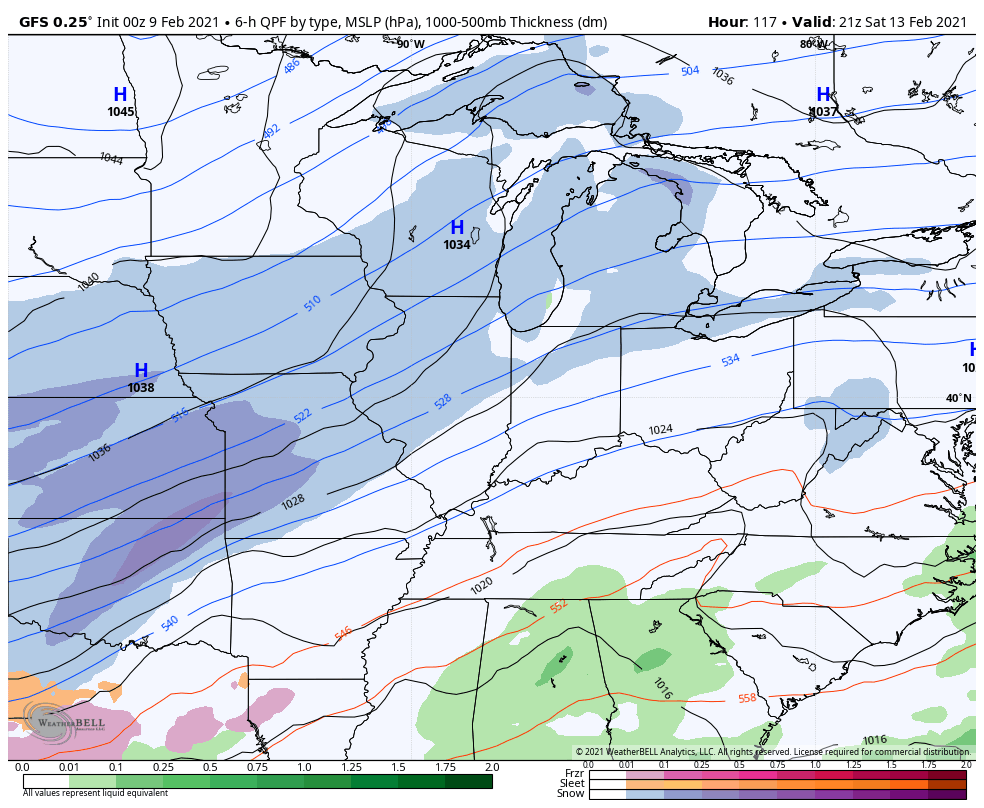
This brings us to the Winter Storm ALERT from late tonight through Thursday. This may develop into a full blown ice storm for several areas and I expect Winter Storm Warnings and/or Ice Storm Warnings to go up at some point today. Here’s a look at my generalized idea…
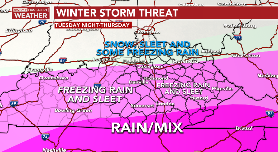
Here’s a breakdown of how this may play out:
- A wintry mix and rain moves into southwestern Kentucky tonight and develops northeastward through the day. Southern Kentucky is likely rain at this point, with the snow, sleet and freezing rain across the northern half.
- Heavy amounts of precipitation arrive late Wednesday and continue through Thursday. During this time, temps drop from north to south and that takes the frozen line into southern Kentucky. A large swath of significant freezing rain is likely to show up. Odds favor a broad west-east corridor of .25″-.75″ of pure freezing rain, with a few areas potentially pushing 1″. This is the area highlighted in the above map with “Freezing Rain and Sleet”.
- These kind of amounts would be enough to take out some tree branches and cause power outages. It would be a good idea to have a plan in case you lose power.
- An area of sleet and snow will likely show up along and north of Interstate 64. How much can fall is still in question, but the potential for several inches is there.
- I will have a complicated First Call For Ice and Snowfall around noon today.
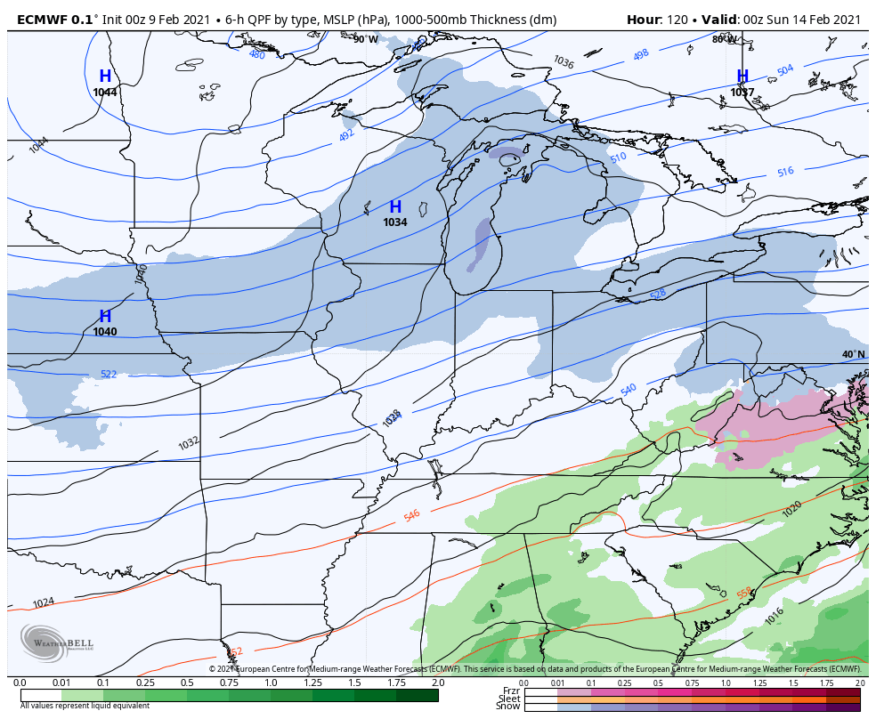
The EURO continues to be VERY concerning with the amount of freezing rain it’s spitting out…
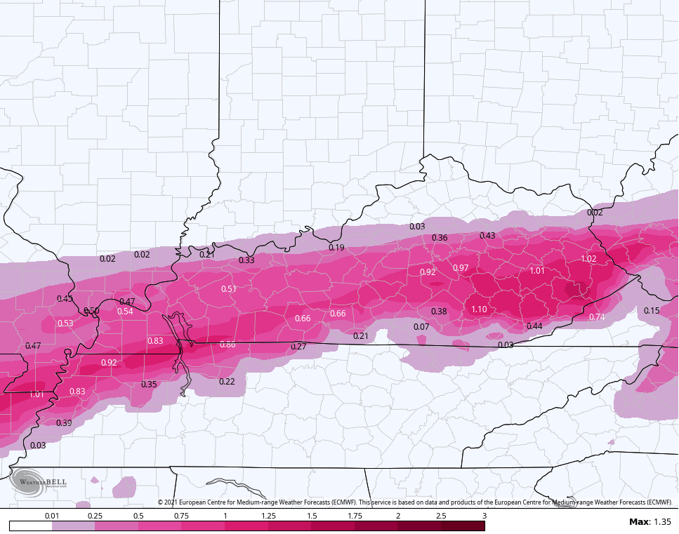
If you anyone gets those kind of totals, you’re looking at massive issues. This is especially concerning across the more rural areas where power lines aren’t as accessible for repair.
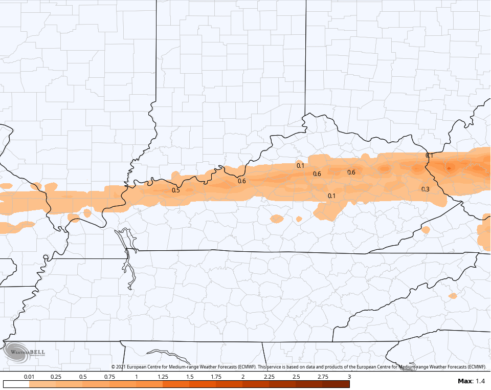
Here’s the sleet forecast from that same run…
And the snow forecast that also includes some of last night’s and this morning’s snow in the far north…
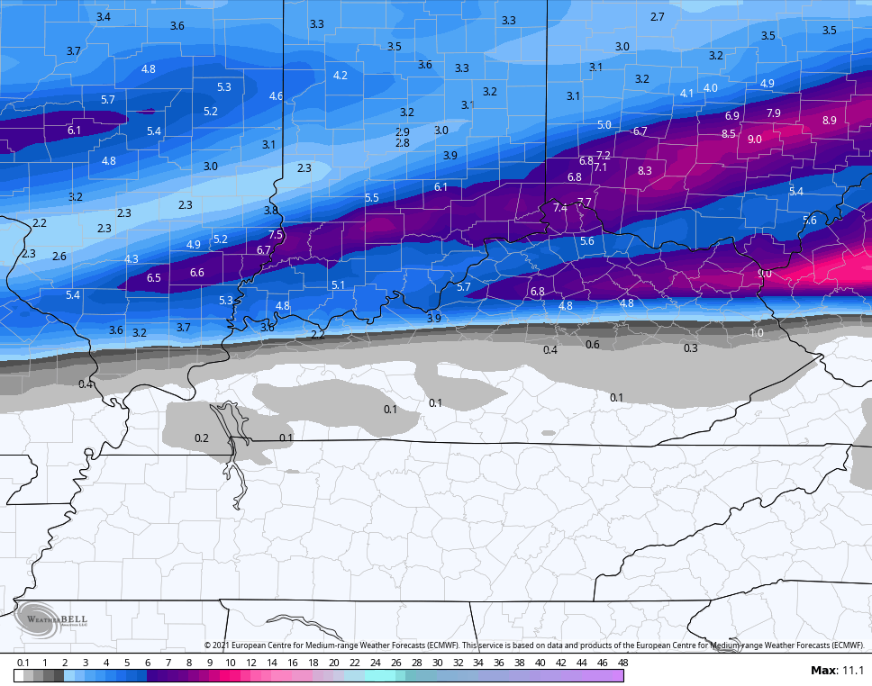
Do ya see the sharp edge on the south side of the accumulating snows? That’s insane, but not uncommon with setups like this. It makes for a big time challenge, but I’m up for it… I think. 😏
Behind this comes the potential for several more winter storms. One may impact us this weekend with another early next week. Here’s the GFS…
The EURO brings below zero air in this weekend and crushes that system off to our east, but it brings two winter storms in here early next week…
I will have updates today, so check back. Have a good one and take care.

Yikes an inch of freezing rain would be devastating. I hope it pushes further south.
Well it seems winter has finally returned to some kind of ” normalcy “of yesteryear. Thumping snow just a few counties north of us ( Lexington) and mix and rain as you go south. Welcome back ol man Winter!
Yell, the rain snow line push a little to the north overnight. Not a good sign. Louisville is definitely on the fence.
Usually these push more south, so even more irony. The cold air outlooked by the models has been a big bomb.
We Had A Very Quiet Night And Early Morning With A Current Temperature Of 32 Degrees F.
Barometric Pressure Steady. Not Expecting Any Precipitation Here Today In Taylor County.
High Today Is Expected To Be Near Or Above 40 degrees.
Confidence Is Still High For The Ice Event On Thursday, But Low On Where And How Much Freezing Rain/Sleet Or Snow Will Fall and How Much.
As Always I Expect The Worst And Hope For The Best.
Fencetucky.
JKL says the ICE stays north of Hal Rogers Parkway thru Thursday
Nam shows a pretty big event like the Euro for southern and south EKY.GFS not so much for the first wave.Hard to decide if one should go lug 40 gallons of gas for the generator or not.Any suggestions.lol
Personally, I’ve been stockpiling stuff since this thing first appeared on the horizon. I had a bad feeling about it, and usually my “feelings” don’t steer me wrong. We still have 2 huge bags of ice melt that we got last year for a storm that never materialized, so we’re good there, and I went to the store Sunday and yesterday for needed food that can be put into a cooler and set on the deck, got my lamp oil(I kept my late grandma’s oil lamps which have def come in handy through the years!)and batteries. Have all the big blankets and comforters ready. We just moved into a new home in late 2019, so I don’t know how the electricity grid is here yet. In our other home for many years, it was an older area of town and the main transformer for our street was in the back corner of our backyard, surrounded by 40+ y/o trees, so it was a given we’d lose power at every thunderclap or ice pellet-but we didn’t in ’09, which was really weird..??! Lost cable tv, but we’d have had it back on 5 days sooner if the out-of-town dimwits hadn’t insisted that the line down in my b/y was my neighbors’ phone line…..I broke my collarbone during that one, but it was when the ice was melting. I’d let the dogs in and I stepped in a muddy paw-print and threw myself into the wall. LOL! Not going to make that mistake again. I bought a big rug and put it down in front of where the dogs go in and out the back deck door! 🙂 But we now have a 6 m/o Lab puppy that’s already about 65 lbs. and runs on 2 speeds-Ballistic and “Oh-Holy-Crap!!!”, sooooo…???! 😀
YES ! Get Prepared For The Worst And Hope For The Best.
I’m Scared Because I Probably Won’t Have Any Heat In My House For A Long Time.
The Latest Forecast Has shifted The Ice Storm South And My County Of Taylor Is Right In The Center For the most Accumulation Of Ice.
Just Like It Was In 2009. I Pray that It Won’t Be Though.
y
Don’t trust the models. Back in January 1977 when the infamous blizzard hit here in KY the only thing that was in the forecast was chance of flurries. Will never forget that only mother nature knows .
Yep. I remember! I was 15. Here in Bardstown, if I remember correctly, we didn’t get a lot of snow with it, but I remember when it came through that night-my mom and I lived with my grandparents out in the country, and I slept with Mom that night with all these homemade quilts on the bed to keep warm-we had a propane stove, but Papaw had built this ingenious wood stove thingie in the basement with vents in each room because propane was expensive back then-still is! Anyway, it was really LIGHT outside, and the tree limb shadows were reflecting through the windows onto our ceiling, and the wind shook the house…I was convinced that the ceiling was “cracking” and the roof was going to cave in!!!! LOL! Next morning, we got a call from good friends/neighbors up the road needing my Grandpa. His friends’ wife had a seizure, and they lived back this little narrow road with a big hill leading to their home, and they needed him to bring his Scout to help push the ambulance up to the house and then back up the hill going out. She had a brain tumor, which luckily they were able to operate and she lived for another 20 yrs…..wow. Funny how you remember things, huh?
Yes Debbie it sticks to your mind. Those late 1970′ s winters were memories we can’t forget and it’s strange we have endure those type of winters since.
We have not
I apologize it was January 1978 when the blizzard hit
I’m hoping for your guys sake that the icing is way overdone on the models. What is it about Kentucky that you always get ice storms? We don’t ever get more really than a 1/4th to 3/8ths of an inch of ice. Anyways, here in south-central Indiana last night I had my biggest snow in over 3 years with 4.2″. Some areas south of me had 6-7 inches which still wasn’t as much as what happened near the Cincinnati area.