Good afternoon, everyone. Much of the bluegrass state is encased in a block of ice as our storm slowly begins to pull away from the area. But, we have no time to rest as we already shift into Winter Storm THREAT mode for Sunday night through Tuesday. Oh and another storm will follow that up.
We are still a few hours from closing the book on the ice storm of 2021 that will go down as the third worst ice storm of the last 25 years or so. Only 2003 and 2009 surpass this one, but those are in a league all their own.
Light freezing rain, sleet and snow continues across areas of southern and eastern Kentucky, adding to more issues. This action slowly ends by evening with some freezing drizzle leftover into tonight. Here are your radars…

Clouds are usually tough to get rid of in a setup like this, so I’m not too confident on much melting into Friday. There could even be some patchy freezing drizzle or a few flakes for some.
The next system arrives Saturday with a light wintry mix, especially across central and eastern Kentucky…
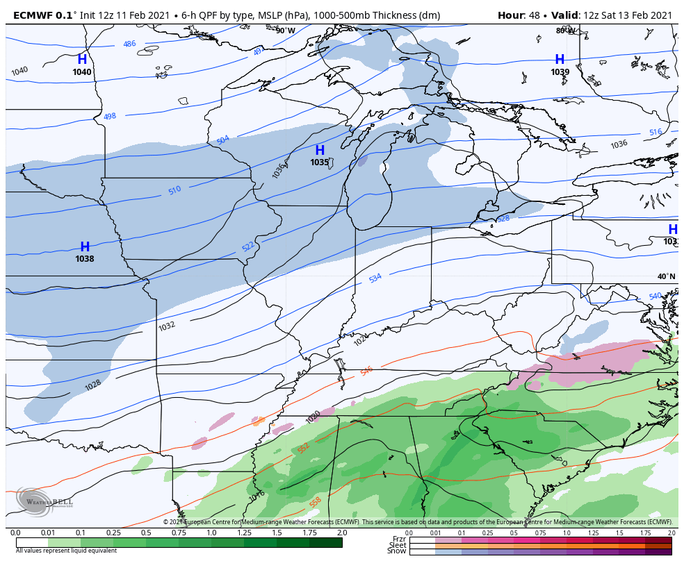
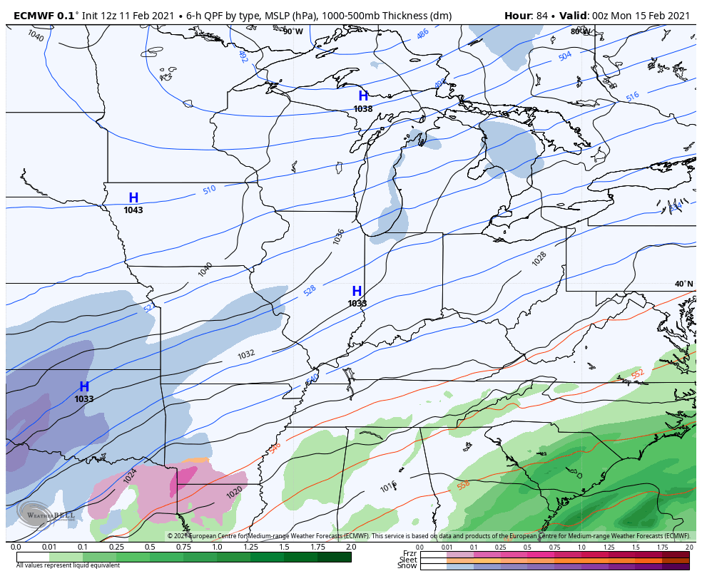
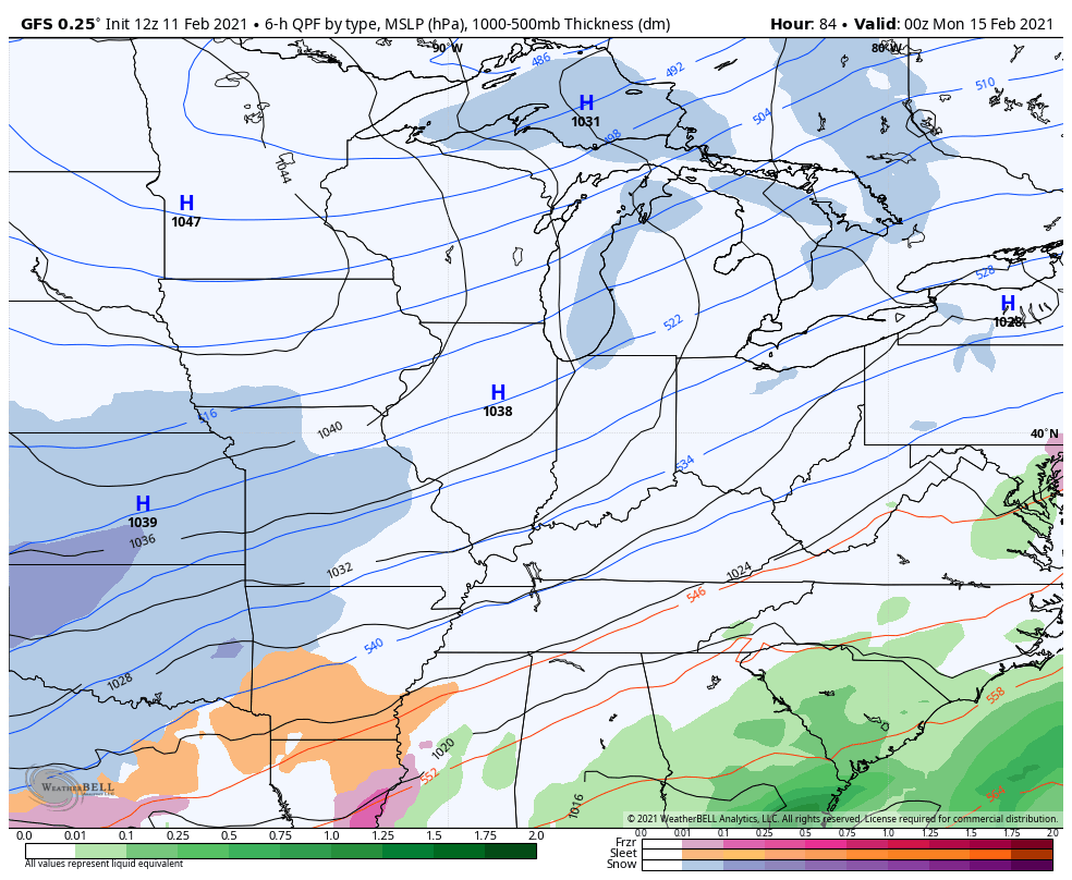
A developing winter storm will then quickly move into our region Sunday night with waves of snow, sleet and freezing rain through Monday and Tuesday. Significant amounts of each are likely to fall during this time.
Another winter storm will likely follow that up by Wednesday night and Thursday. These two have the potential to effectively shut down parts of the Ohio Valley.
The models continue to play around with the track of each, but that’s to be expected. Here’s the EURO…
And the GFS…
Given the fact many in our region, especially rural areas, may still be without power when these storms arrive, things could go from bad to flat out ugly.
I will be updating these storms on WKYT through the evening and with another KWC update this evening. Make it a good one and take care.

As long as my area in the state stays predominantly snow, I can deal with it.
if some of the models pan out, looks like the entire state gets smacked hard with ice at the tail end of the system. Yuck!
Not going to say a word , I’ll jinx it.lol
Too bad the colder air did not come down from Canada like the models kept showing, since would have made this last system a big snow for most and tamed the second of the next two systems coming. That second system looks rough and as we’ve seen- the models do way better with ice than snow. Thanks for nothing, Cold Air! Without the colder air to offset that moisture flow…. Could be bad.
The strong Southeast Ridge has been keeping the deep cold along with the Snow out of Kentucky for years now.
If there is such thing as “weather control” I wish they would take this high pressure out. LOL
Bubba G the Arctic air is still in the forecast here in western, ky by Saturday our high for Sunday is15 and the low near 0 Sunday night. The air will be cold enough for snowfall if the models are right.
It can only be Snow in our area if an upper level low (-) on the Polar jet phases with a surface low(+) on the Subtropical Jet and moves through Eastern Kentucky. Then we will end the Snow drought in Western and Central Kentucky.
With the way this Winter has been so far I don’t see the above playing out at this time.
In my local forecast they are calling for just Snow Showers on Tuesday. However the Blizzard of 1978 was not predicted and a lot of people lost their lives.
I heard on the weather news out of Louisville that we may have a phasing storm system on Monday.
On the Ventusky Weather site it showed the Arctic Air spilling back over to Siberia by the 20th of February and we will warm up.
I live in a very rural area and still have power. If it goes out it will be out for at least a month.
Aside from a light glaze of ice on our trashcans and mailbox, we ended up with just a trace of freezing rain at my observing location near Bowling Green. My PWS recorded 0.30″ of rain between 11:30 pm CST and 3:15 am CST, but since the temperature didn’t dip below freezing until 2:45 am CST, we ended up with about a half hour of light freezing rain at my location. Power outages were restricted to the extreme northernmost part of Warren County. As of 8:00 am CST this morning 691 customers had lost power, and as of 3:00 pm CST, 25 customers remained without power.
Someone needs to figure out how we can get electrical power in our homes without wires ?
Some newer subdivisions have underground utilities. I thought we’d escape a power outage, but this morning around 2:30 just as I’d settled into a good sleep, my phone and nightlight started going loony and everything went out. By the time we got our lantern and batteries changed in the radio, it came back on. The minute I hit the bed, they went off and there were a couple green power flashes out front. Elec. came back on sometime after that and they changed out a transformer across the street. In my old neighborhood, the light pole by my house came crashing down, lines and all. That would’ve scared me to death!
Nikolai Tesla had it figured out, until J.P. Morgan shut him down…
Just watch the weather channel there saying the Sunday to Tuesday threat. Is online what Chris is talking about. There were talking how Hugh of a storm this will impact most of the country snow from the northwest down to Texas and up to. our state of ky and upward to northeast. There say this could be a snoozer one.
A blockbuster one that is
That one sounds like it will break Snowfall records.