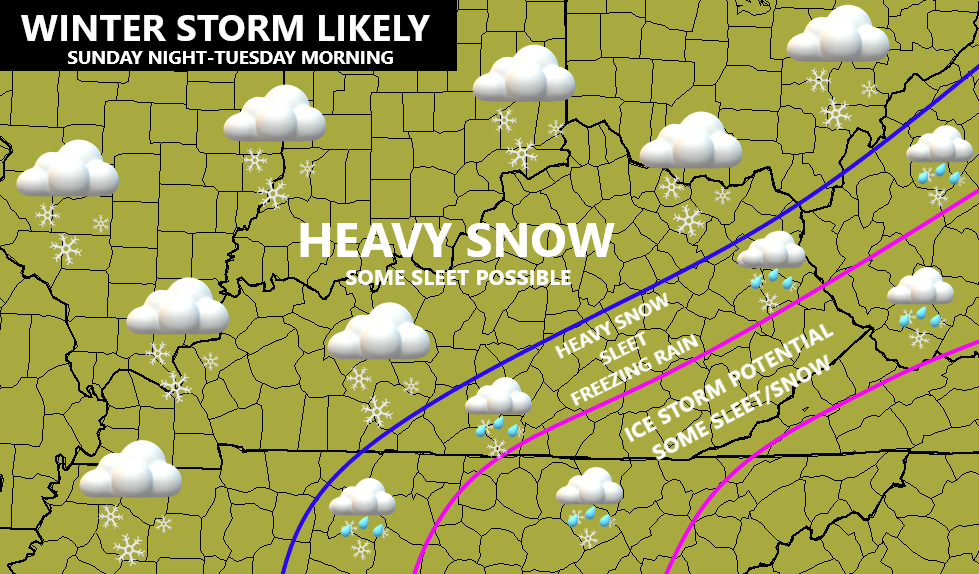
Good Saturday, everyone. A major winter storm is on the way to the bluegrass state and the entire region Sunday night through Tuesday AM. This will bring significant amounts of snow, sleet and freezing rain with it, causing a lot of issues along the way. As we get closer to this storm, there’s been a a trend for a colder, snowier and farther east solution.
Before we get to the winter storm, there’s a little winter action out there today. Some very light snow or light freezing rain/drizzle is showing up across areas of central and eastern Kentucky. Light accumulations may cause local travel issues to develop. Here’s regional radar to see if any of this light stuff can actually be detected by radar…

Now let’s get to the winter storm portion of the program. Here’s a breakdown of how things look to play out…
Remember, that’s an approximate outline, but it’s the best I can do at the moment. 😁
I will get a First Call map out by early afternoon.
Some headlines:
- Winter Storm THREAT from Sunday night through Tuesday morning.
- This is a storm that comes at us in two waves with the first arriving Sunday evening and taking us through Monday morning.
- Snow, sleet and freezing rain overspread the region from the southwest. Road conditions will quickly go downhill during this time.
- After a brief lull in the action around midday Monday, the main surge of heavy snow, sleet and freezing rain moves in.
- Significant accumulations are likely and this may turn into a shut down storm for many. Some areas in the all snow zone may push double digit snowfall totals. Keep in mind, areas getting the snowfall will be in arctic cold air so we will be looking at roughly 15-1 snow ratios.
- The ice accumulations in the east will have to be watched very closely as it won’t take much to cause major power outages.
- Winds will also be a player with this storm and we may see some blowing and drifting snow at times. Winds may gust to 25mph.
- Temps behind this could make a run at zero in some areas Tuesday night.
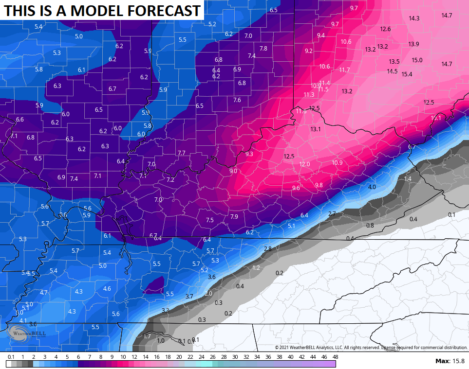
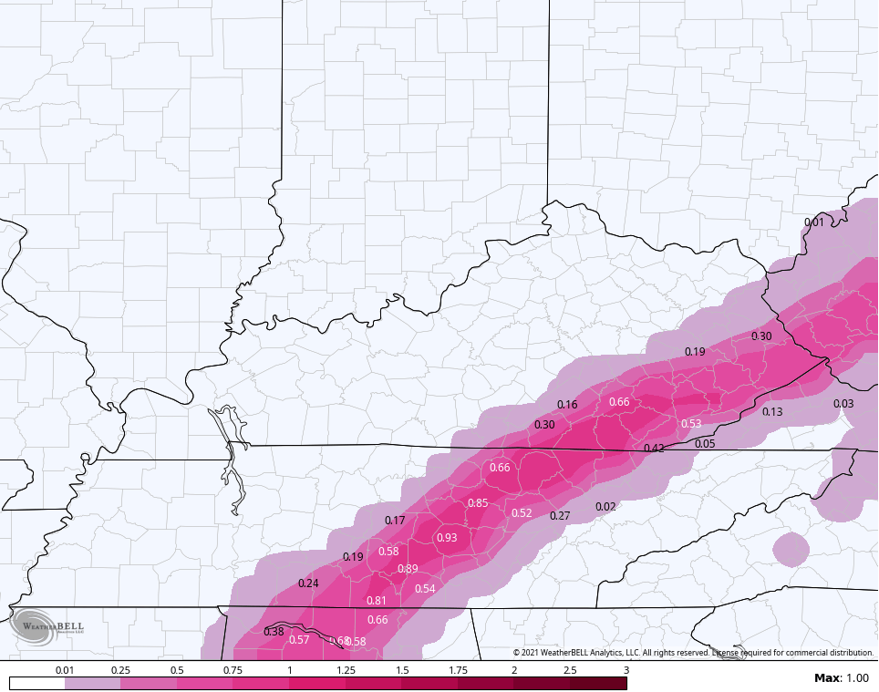
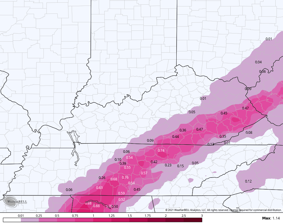
In terms of the latest models, there is a little trend toward the east with a colder and snowier solution. Here’s the GFS…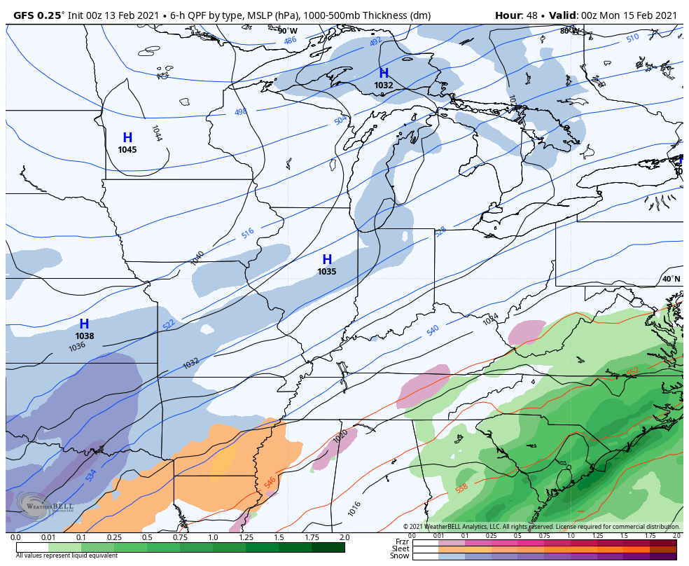
Snowfall
Sleet
Freezing Rain
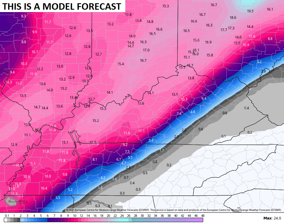
The NAM just blew up with snow as it trended much colder…
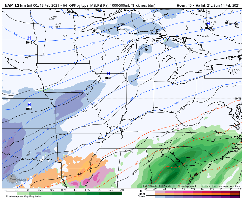
The snowfall forecast from this run has a shut it down type for a lot of the state…
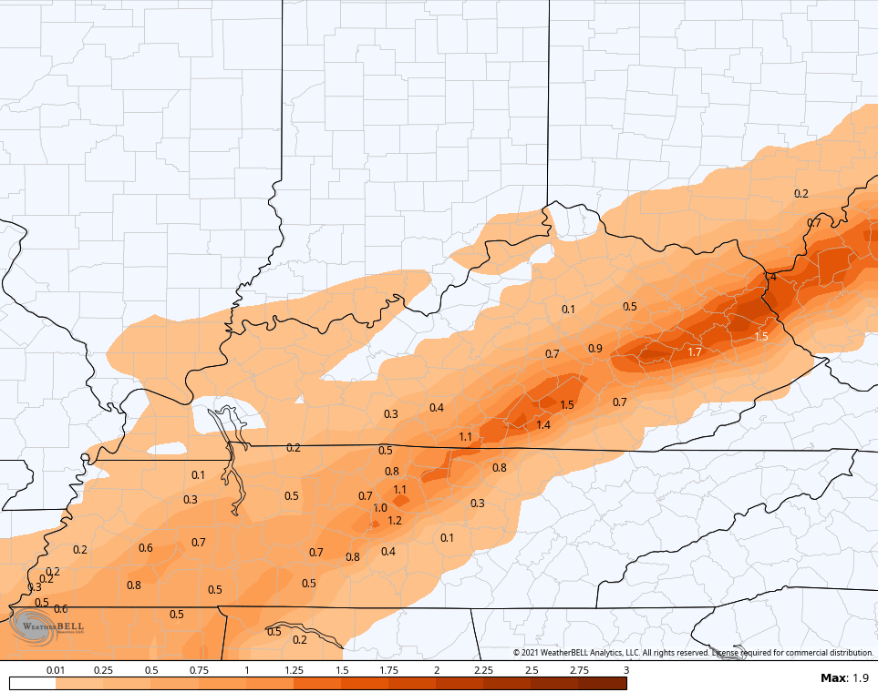
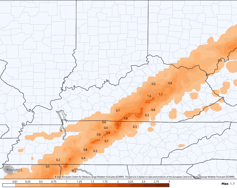
Here’s the sleet…
The freezing rain signature is even farther east and not as aggressive…
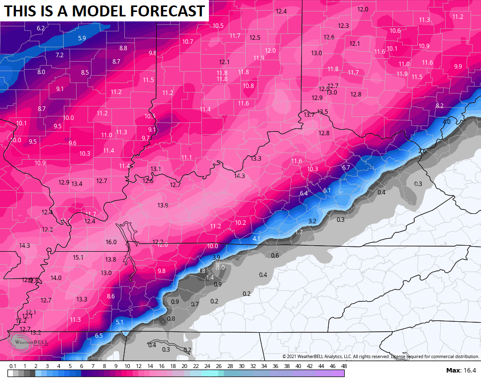
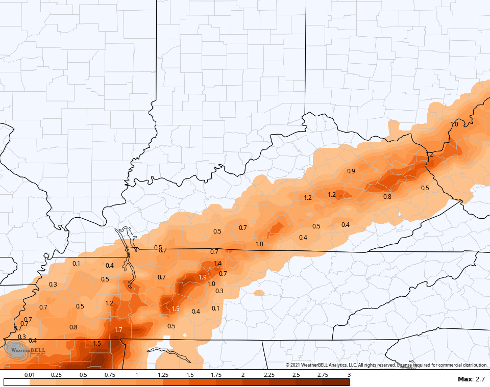
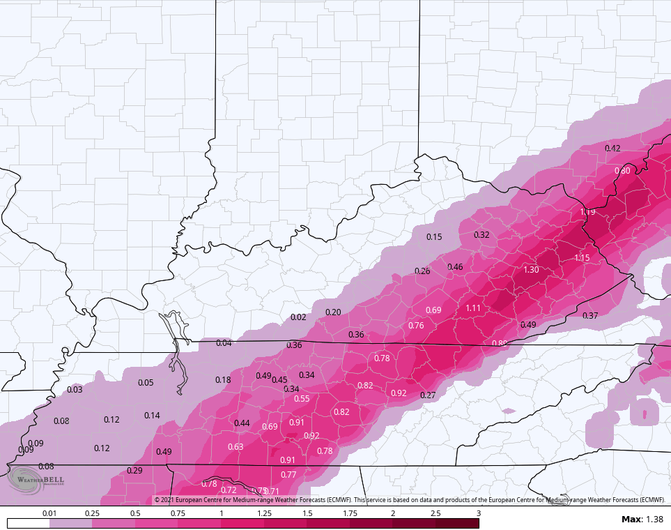
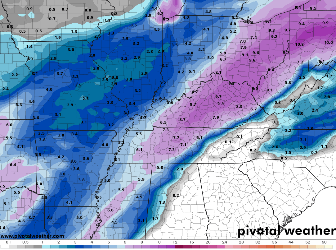
The European Model is very similar…
Snowfall
Sleet
Freezing Rain
You can see how the EURO has much more ice across eastern Kentucky. I don’t even want to think about what happens if those areas pick up that much ice. Devastating.
The UKMET only gives us a snowfall map and it’s only based on a 10-1 ratio. The model is farther east, but it’s likely adding some sleet to inflate totals in the far east and southeast…
So there you have it. This is going to be a major winter storm that will likely cause widespread issues and may shut down some areas.
I will have another update by early afternoon and will get a First Call For Ice/Snowfall around that time.
Enjoy the day and take care.

I went to the groceries yesterday. The store was already packed with customers. Anyway I am prepared now. I have all my favorite foods & adult beverages.
Bring it on!!
bailey boy,solid work this week from the whole weather team!!!! how bout you get out in the field some. let adam or jim do studio. miss blake a solid edition.
Hope everyone stays aware and informed. This is a dangerous potential situation.
It’s a very cold 5 degrees above zero this morning here in the SW suburbs of Chicago, with a wind chill of 10 below. Light snow is falling, with more light snow to the west. About a half-inch has fallen so far, with about another inch expected before noon to add to our heavy snowpack.
Wind Chill Advisories are already out for the Chicago Metro Area for late tonight and Sunday morning, as temps are going to drop well below zero tonight with wind chills approaching 25 to 30 below zero.
Thanks Chris For The Update. Lets All Hope This Storm Moves In And Out Quickly And Robs The Energy From The Mid Week Storm ?
Hoping That The Temperature Will Get Above Freezing Today And Tomorrow. Sunshine Probably Not, But that would Really Help.
My Local Weather Forecast This Morning Includes All Three Precipitation Types For Late Sunday Into Monday With Snow Showers Before Ending. No Mention Of Any Heavy Snow Accumulation Locally.
Hoping We Will Keep Our Power On And Tree Damage Is Not Severe.
Maybe By Next Weekend We Will Begin A Long Warming Trend And End This Awful Messy Winter ?
Taylor County is not in the heavy snow zone.?
Right, Taylor County Is Not In The Heavy Snow Zone.
If We Didn’t Have All This Ice On The Trees I Would Want It To Snow Buckets !
What a ride. It’s been a while since this much winter is hitting us back to back. Thanks Chris for all you do. I’ve been gone for some time and it’s good to be back.
Welcome Back Feederband Hope You Post More. I Post Too Much, But I Love Discussing Weather With all On KWC.
Right, Taylor County Is Not In The Heavy Snow Zone.
If We Didn’t Have All This Ice On The Trees I Would Want It To Snow Buckets !
The coming storm has now made landfall.
The 12z model runs will be interesting to see.
True. If this pans out, we would have a lot of snow sitting on already heavy ice covered trees and then 20+ mile and our winds… We could maybe have some of the worse downed trees and power outages in decades- plus zero temps to deal with. Facto in folks would be stuck at home. Could be interesting. Noticed last night that Richmond area has a lot more ice than Lexington.
Not recalling where we got significant ice that stayed around for days until a big snow or additional ice event- usually there is a thawing before. Wild stuff.
To Make It Worse BubbaG We Have this “Devil Made Virus” Around. I’m Not Going Anywhere.
If I loose Power I Have A Blizzard Coat To Keep Me Warm.
I Won’t Have A High Electric Bill, But Maybe A High Water Bill With The Drip Drip Drip……… To Keep The Water Pipes From Freezing.
My sister in Longview WA (far southwest on the Columbia River) has 9″ and it is still snowing. They think by the end it will be in the 12-15″ area. Get ready. Prepare.
This Storm Is Just A Surface Low And It Could Miss Us All Together To the Phasing East Of Us.
Just Being Optimistic.
BubbaG Is Right You Do not Want A Heavy Snow With This Much Ice On The Trees And Power Lines.
That Would Cause So Much Damage To Property One Would Never Recover And Your Property Would Be Worthless.
Reading JKL is like reading Chinese.Mentioned a warm nose in some of the higher elevations Monday thru Monday night with temperatures 40 degrees or higher.Plain rain.Last ice storm was a big bust for Perry and surrounding areas so hopefully this one is another bust.Like last system sitting here and still don’t have a clue what to expect with all the different model solutions.
I heard That In The Blue Ridge Mountains That Ice Storms Are Very Rare Just Like Snowstorms Are In Kentucky.
LOL. Guess that’s a good thing if you live in the Blue Ridge mountains.The warm nose I speak of is for Harlan,,Whitesburg,,Middlesboro.Higher elevations.Personally would like to see a 70 degree warm nose starting about right now.
Hmmm. I don’t know. I’m from Brevard NC and I remember several ice storms…Although I will admit I don’t ever remember seeing any like we had here in Lexington in 2003 or 2002, I always forget that year that was.
Also I wanted to see how the temps matched up to NWS forecast high yesterday for Lexington. Their forecast was for 33 but it stayed several degrees colder all day. So maybe the colder solution is correct
MarkLex. It was in 2003. I wish I could forget, but it is etched in my mind.
Seems that since this is considerably colder air, this might be ice for some that only got cold rain the last time. Again- if the flow of the system pans out. The last one basically did, so can’t be laughed at like previous ones could.
If you have ice on your trees like Richmond you want sleet, since it bounces to the ground. Snow will pile up on the trees and catch the 25 MPH winds to make mass fall down fodder. Seriously, this is the first time we’ve had an ice event that did not thaw before snow came days later. If this pans out, we have a big system coming with no need to wait for accumulation to build up on a warmer ground.
IF this pans out, next week could be one for the winter misery record books for KY. We’re talkin’ Wildcat basketball level misery.
Bubba G I think you and Chris are both right. I think it may get bad. I hope not . I remember the. Last time I heard Chris say it could be a shut down storm it was.
I’m a KY girl living in a Hoosier world. I still check in daily during the winter to see what Chris has to say! These last few winters here in Seymour, IN snow has been next to nothing–I was excited over last weeks 4 inches here. But this one coming–YES! YES! YES!!!!!!!
This going to be an interesting one. Bring the snow!$
I can’t tell what the timing on this is. Can anyone tell exactly ish what will happen Sunday thru Monday MORNING? I have to travel from Frankfort to Louisville at around 5:30 am Monday….(or possibly not!)
And what do these ratios mean? (15-1, 10-1).
Thanks!
Guess you could say the Nam ticked back west a bit.Snow totals a little down.Up and down East to West I guess is to be expected.
Thanks Chris well here in the southeast no snow again but not your fault .I just hope we don’t get that Ice part of it. Sometimes in the eastern section of Kentucky it feels like we are the bad kids in the corner when it comes to snow lol will be following as always for your updates good luck to everyone . Chris I am afraid you are right on it could be a shut down story for some of us in Kentucky. Chris don’t work too hard but I know you will.
It looks like, if all pans out that everybody in Ky gets something. I’m not as excited about this as I usually am. We still have a lot of ice on our trees and then we get more freezing rain/ ice buildup. !!! We were Fortunate not to have any power outages this time we did lose our Wi-Fi. LOL we can live without Wi-Fi , but I feel another round of this Ice would take it down. We are prepared for the worst and like Schroeder says we will hope for the best. Take care every body….
Right, The Good Lord Will Help Us Through This Impending Crisis.
God Bless to All.
Crisis? Don’t be so over-dramatic.
Absolutely
I am Patiently Waiting On Chris’s Next Update.
Situations Like this Make Me Nervous.
The Uncertainty Of The Storm’s Impact.
16 degrees here in Union.co. Barr and waiting on the snow
While waiting for the Euro here the crazy uncle Ukie.Goes out to 144 so I guess it’s counting the Thursday system also.
https://www.pivotalweather.com/model.php?rh=2021021312&fh=144&dpdt=&mc=&r=us_ov&p=sn10_acc&m=ukmet