Good Sunday and Happy Valentine’s Day. A crushing winter storm threatens to shut the bluegrass state down over the next few days as significant amounts of snow and ice show up. This storm will be the strongest to hit the region since January of 2016. We have a lot to talk about, so let’s get after it.
Let me start out with the headline making aspects of the storm:
PREPARE FOR A MAJOR WINTER STORM TONIGHT THROUGH TUESDAY
SIGNIFICANT AMOUNTS OF SNOW AND ICE WILL LIKELY CLOSE SOME ROADS
POWER OUTAGES ARE LIKELY AND MAY EXCEED THE NUMBERS FROM THE LAST STORM
As far as the normal breakdown goes, things remain similar to what I’ve been talking about for days:
- This storm comes at us in two waves with the first arriving from the southwest late this evening. This will then overspread the state with snow, sleet and freezing rain showing up.
- Amounts will be heavy to begin Monday, but should lighten up just a bit around midday.
- The main storm system then rolls in here with heavy snow, heavy sleet and heavy freezing rain Monday afternoon and lasts through the night.
- It’s important to note that the precipitation types may not be the same where you live from the first round to the main round. The main round will have much colder air working into it and produces a much wider shield of snow.
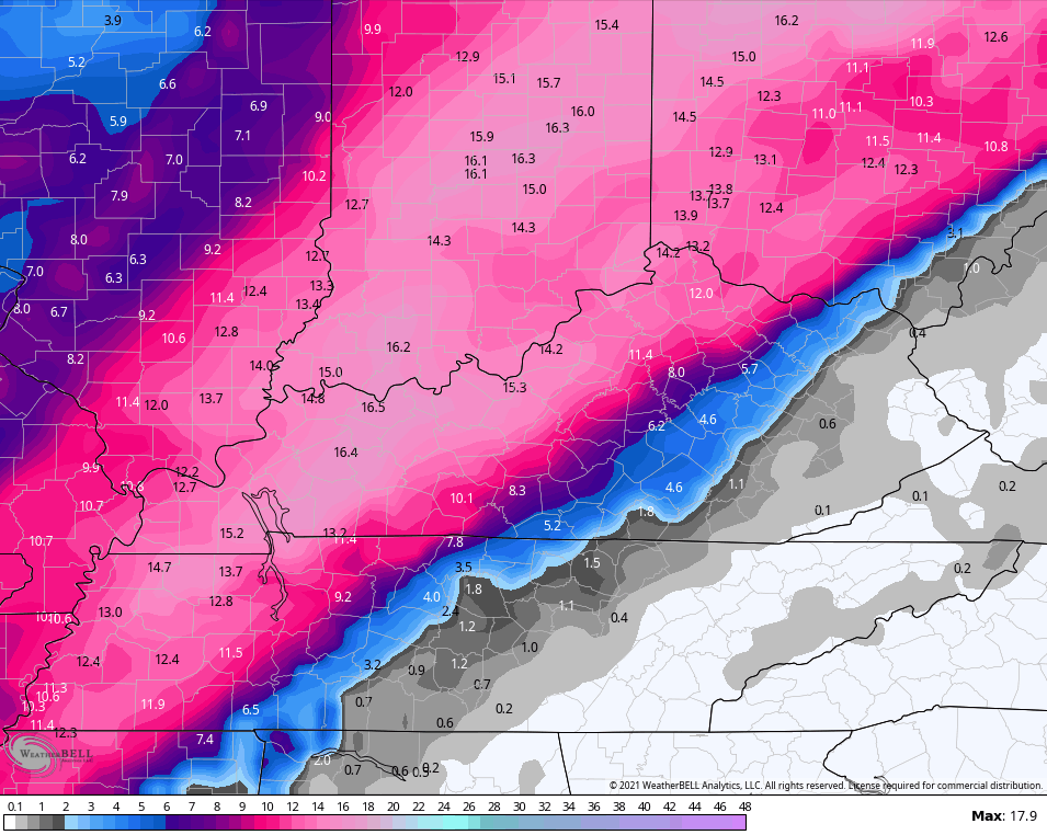
- Some areas are going to push a foot of snow and I can’t rule out some spots exceeding the 12″ mark across central and western Kentucky.
- Areas of eastern and, especially, southeastern Kentucky should prepare for an ice storm. Much of what falls will be in freezing rain form before some sleet and snow try to cut it off. Let’s hope the sleet and snow can somehow wind up farther east. The same goes for our friends in the WV.
- Between the ice storm and the snowstorm is a battle zone of precipitation. This is the area where totals get tricky because any one precipitation type may try to be the dominant factor.
- Winds are also going to be a player. Gusts of 25mph will be noted during the heart of the storm and could create blowing and drifting snow. Below zero wind chills will also show up by Tuesday and Wednesday mornings. Temps may even be near zero or below.
- Areas where we still have ice clinging to trees and powerlines could see additional power outages and some trees come down. That goes for those seeing ice or snow.
- Have a plan in place if you do lose power.
- As far as travel is concerned… Don’t.
I’m leaving my latest Call For Snowfall in place as I haven’t seen anything that makes me want to change anything…
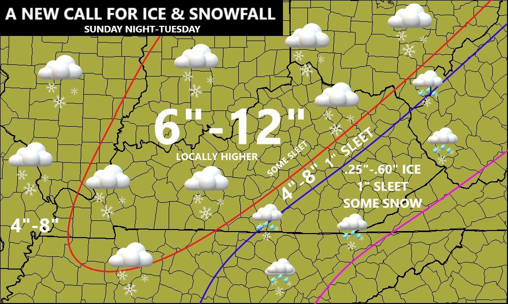
The buffer zone I have for 4″-8 with 1″ sleet is the area to watch. Any deviation would put you guys in a little more freezing rain or a little more snow. Obviously, both would impact totals.
I will update that map as needed throughout the day.
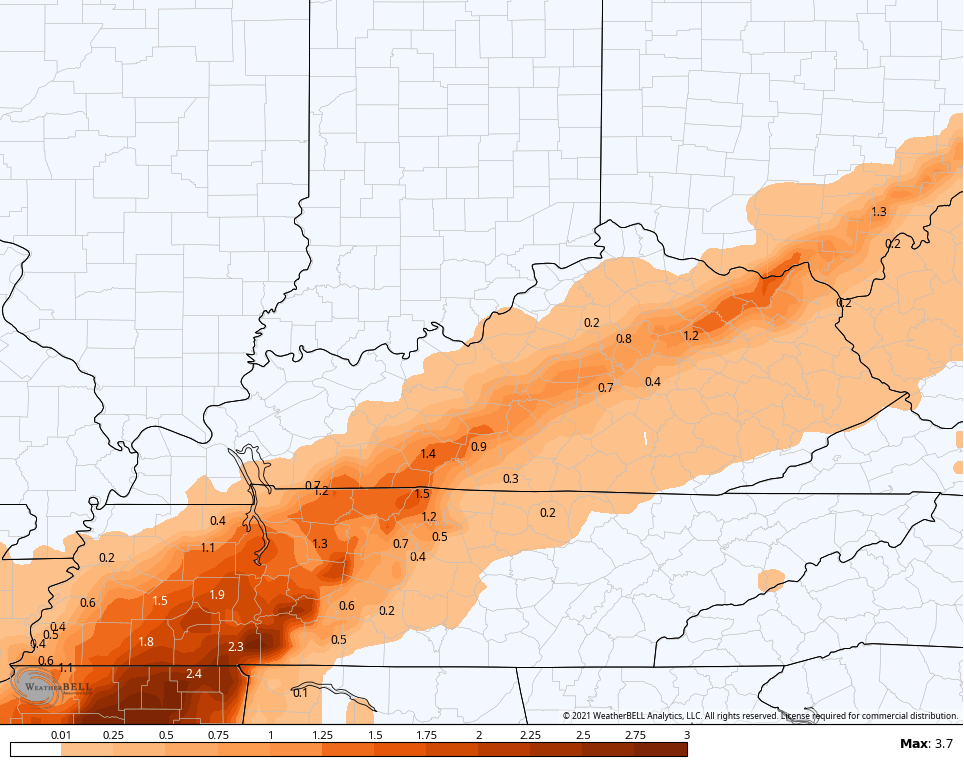
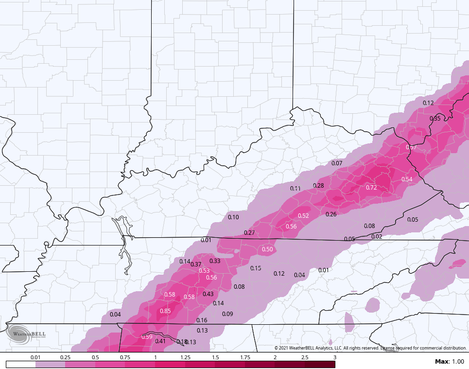
Let’s take a look at what the models are offering up:
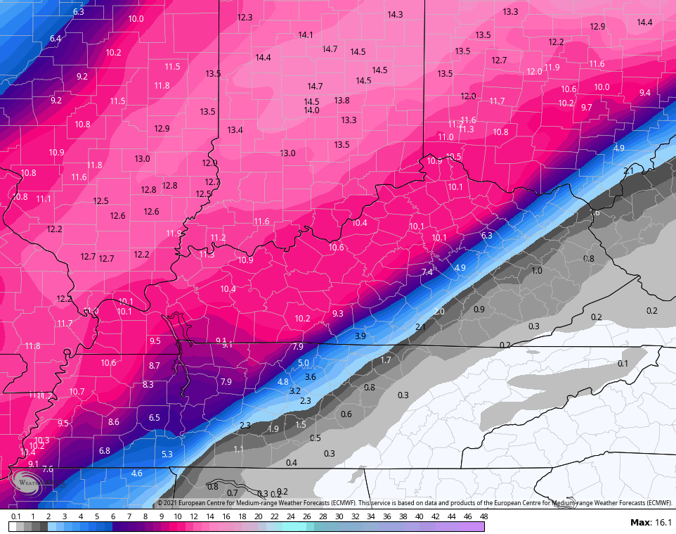
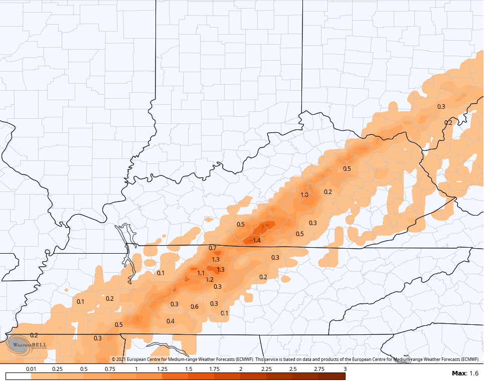
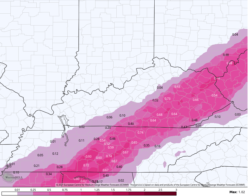
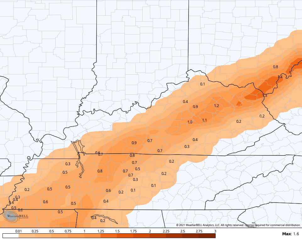
The EURO continues to drop the hammer with this storm…
EURO SNOW
EURO SLEET
EURO FREEZING RAIN
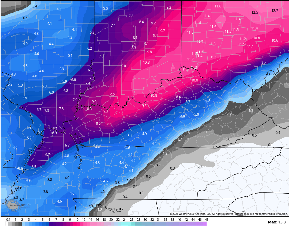
The NAM usually overdoes warm air advection, leading to a solution that’s usually a bit too far west…
NAM SNOW
NAM SLEET
NAM FREEZING RAIN
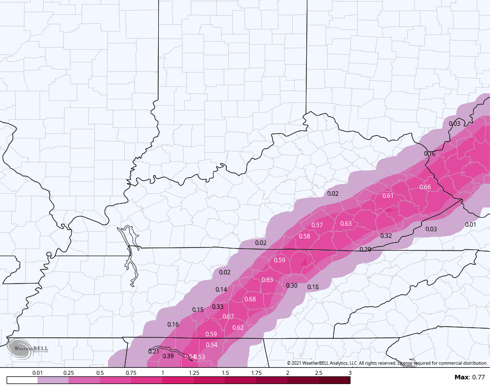
The GFS continues to be a little more tame when compared to all the other models, but is still a major hit…
GFS SNOW
GFS SLEET
GFS FREEZING RAIN
The Canadian family of models is much more generous with the snowfall swath…
CANADIAN SNOW
SHORT RANGE CANADIAN SNOW
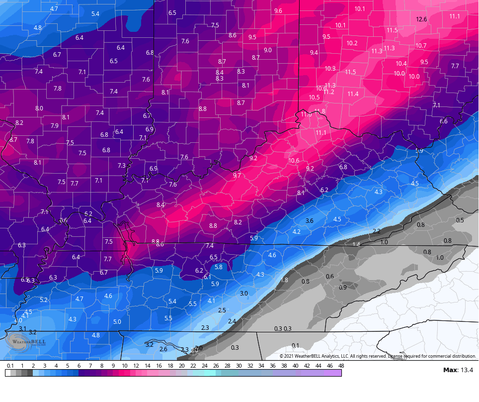
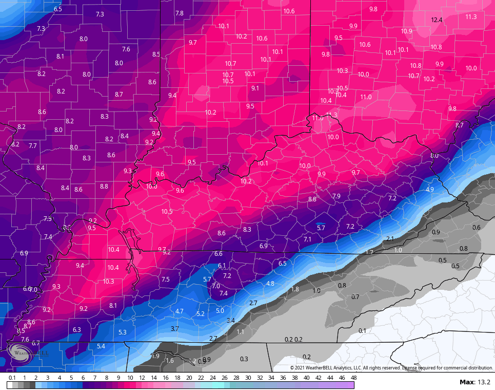
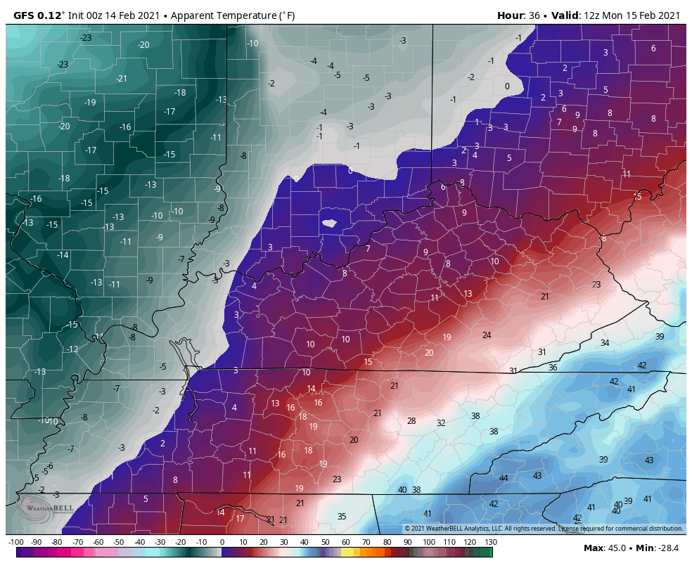
Check out the brutal wind chills that come along with this winter storm. This animation goes from 7am Monday through 7am Wednesday…
Yet another winter storm will follow this up by late Wednesday and continue through Friday. Significant amounts of freezing rain, sleet and snow will show up with this one. Temps may once again hit the single digits or go below zero.
Remember when I said this pattern would become memorable? Little did I know it would include 3 winter storms in a week… Something I’ve never seen or even heard about locally. Actually, this is one of the harshest winter patterns on record for many areas of the country.
This extreme pattern is also taking a toll on this site. I upgraded servers at the start of winter and that worked well, but this current pattern is bringing unprecedented traffic to KWC with more than 2 million views this week alone. Upgrading to a fully dedicated server is my only choice from here, but a migration to that server can’t happen during right now because it would take the site down for a while. That can’t happen until we are out of this extreme pattern, so hang with me.
I will have multiple updates through the day, so check back. When the site is slow, I will also post a lot of the information via Twitter.
Have a good one and Happy Valentine’s Day. Take care.

Prayers for all snow and those that get ice. Prayers also for Chris. He will need all he can get before this week is over. Stay safe everyone!
“… but this current pattern is bringing unprecedented traffic to KWC with more than 2 million views this week alone.”
That’s because you’re so dang accurate! And a great teacher. Been following you for three years. Appreciate you. Stay safe.
Great information! Thanks so much Chris. Prayers for all.
It’s a bitterly cold 6 degrees below zero here in the SW suburbs of Chicago this early morning, with a wind chill of 18 below. It will barely get above zero today, and more snow is on the way for the area tonight through Monday night which will produce several more inches. Areas near Lake Michigan will get the most snow out of this with the Lake Effect.
Looking at the NOAA national weather map at http://weather.gov, it’s amazing how much of the country is under a Winter Storm Warning or Wind Chill Warning/Advisory. The entire states of Texas, Oklahoma, and Arkansas are under a WSW, and most of the states of Louisiana, Mississippi, Tennessee, and Kentucky are under a WSW. Talk about an extreme and memorable pattern… wow!
Enjoy the snow you will be getting there in Kentucky and stay safe! Hope the freezing rain/sleet amounts in eastern and SE Kentucky can be cut down with snow.
Thanks Chris For the Updates. You Are Doing A Great job Keeping Us Updated On All Weather Events !
Prepare Everyone For The Worst And Expect The Best. I Can’t Say That Enough !
Prayers To All And Stay Safe.
Well, I was finally able to log into the website after trying for several hours last night.
Looks like we may get mainly rain in the mountains. NWS giving a high of 36 Monday with only a trace of ice accumulation. We usually get the exact opposite of what everyone else gets – it will snow here but rain everywhere else and vice versa due to Pine Mountain trapping cold air and holding warmer air in depending on the weather system.
Looks like it is more north, which could mean big ice where some were thinking big snow. Hopefully colder air wins one this time.
WPC indicates that the cold air mass is trending colder than previous forecasts. The 15:1 rain/snow ratio seems a sure bet, although the NWS Bowling Green forecast for a “Wintry Mix to Snow”, with a total accumulation of 3 to 5 inches seems ultra conservative. The temperature at my PWS is 23° and should remain in the low to mid 20’s through the afternoon, and once the precipitation begins, adiabatic cooling will drop it further.
If the temps don’t come up will be all snow
It looks like it’s going to be the biggest snowstorm here in Indiana since January 5, 2014 and I’m ready for it.
Spring can’t get here fast enough.I guess Chris knows now that GoDaddy is not reliable.From what I’ve read WPX is a lot better.