Good evening, folks. The first wave of our winter storm is moving in, bringing heavy snow, sleet and freezing rain. This will cause some nasty travel to develop overnight with the worst yet to come. The main wave of the winter storms overtakes the region Monday afternoon through Tuesday morning.
A Winter Storm Warning remains in effect for most of Kentucky with an Ice Storm Warning for a few counties in the southeast…
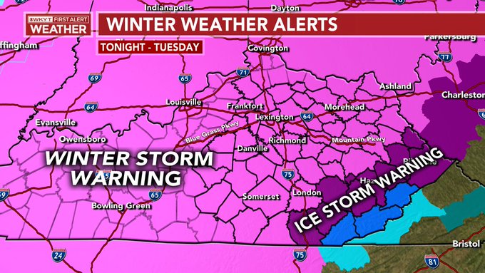
That Ice Storm Warning needs to be expanded and it needs to be expanded in a hurry as the freezing rain signature is more widespread than the current warning.
I have no changes to the ongoing forecast…

People are asking me why the big spread showing up with 2″-8″ of snow. That’s because this is the buffer zone region where snow, sleet and some freezing rain will do battle. This means a very sharp line of accumulating snow and I don’t know where that sets up totally. If you get more sleet and freezing rain, then you’re obviously not going to get as much snow as your neighbors to the west and northwest. Again, I wish I could totally pinpoint where this setups up ahead of time, but that’s not really possible at this point. That’s why the Lexington area is on the fence between a ton of snow and a ton of sleet and some ice.
I will update as needed and be on WKYT tonight at 11. I leave you with your winter storm tracking radars…

Have a good one and take care.

we have freezing drizzle here roads are getting slick and wrecks are occurring be careful in Eastern KY especially rock cuts and Bridges
Very thankful this hot mess is gonna almost completely bypass my home in southern KY
The biggest snow in at least 7 years is coming to the Bloomington, IN area tonight and tomorrow. The NWS is calling for 8-11″ of snow with blowing and drifting expected due to winds gusting 20-30 mph and the powdery nature of the snow.
I have been waiting for what seems like forever just to get over 5 inches from a storm and now I might get double that. I have my shovel and yard stick ready to go. We still have 2″ of snow on the ground from the 4″ we got here Monday night last week. It’s looking very possible our snow depth could reach a foot deep for the first time since March 2015 and maybe our first 12″ snow since Dec 26, 2012.
I Told You Friday Evening That You Were Going To Get A Big Snow.
I Wish I Was Back Home In Washington, Indiana.
Enjoy The Snow !
Yep you were right it moved east some but came right back and now I look to be pretty close to the bullseye.
Glad to finally get on the website again. Seems like Central ky / Fayette co area is always ground 0 of the fencetucky Winter precip type division line lol. I hope snow wins the battle and the ice takes the fall. Keep up the great work Chris!!
Well congratulations western ky looks like your gonna get your snow drought broken . just watched C.B at 11 snow amounts for my location now down to 3 and 3″ of sleet?! Kinda figured it would work out that ways since fridays first call. Hard to see your big potential snow chip away inch by inch . But I’m no ice lover either.
HRRR.Short range expands more NW.Don’t see why there not included in the ice warning.
https://www.pivotalweather.com/model.php?m=hrrr&p=zr_acc&rh=2021021500&fh=30&r=us_ov&dpdt=&mc=
Thanks Chris for all your hard work.
I am on my third ton of salt this season. Will be at six before week is up. Haven’t thrown over a ton in the last four years alone.
I said we were overdue and I liked our chances, but three WSW’s in one week, for Louisville, is overkill. Gonna need a break this weekend , but gonna enjoy every flake we get over the next 3/4 days until then.
Don’t like the use look for the Wed/Thur system. Parts of KY may be shut down for some time.
Seems the trend remains more north NW for main snow and warm air wins again, making a lot of us losers. Hopefully sleet and not ice if pans out.
Warm air is probably winning again. and probably three for three later this week.