Good Monday, everyone. A major winter storm and ice storm are kicking it into high gear today and will shut down much of the Commonwealth. Between heavy snow, heavy sleet and heavy freezing rain, things are going to get very ugly today through early Tuesday. Once this storm moves our, the next winter storm moves in late Wednesday through Friday.
Our first wave of the winter storm is working through early this morning, leaving behind snow, sleet and ice covered roads. This isn’t the main deal by any means. After a brief break in the action, the winter storm really kicks into high gear this afternoon. That’s when heavy snow, heavy sleet and heavy freezing rain develops quickly from northwest to southeast and continues into early Tuesday morning.
As I told you guys, the forecast remains a work in progress, especially with the main wave coming this afternoon. Trying to figure out exact precipitation types and durations is a pain in the backside, especially when surface temps are so darn cold, but temps warming just enough in the mid levels to produce everything.
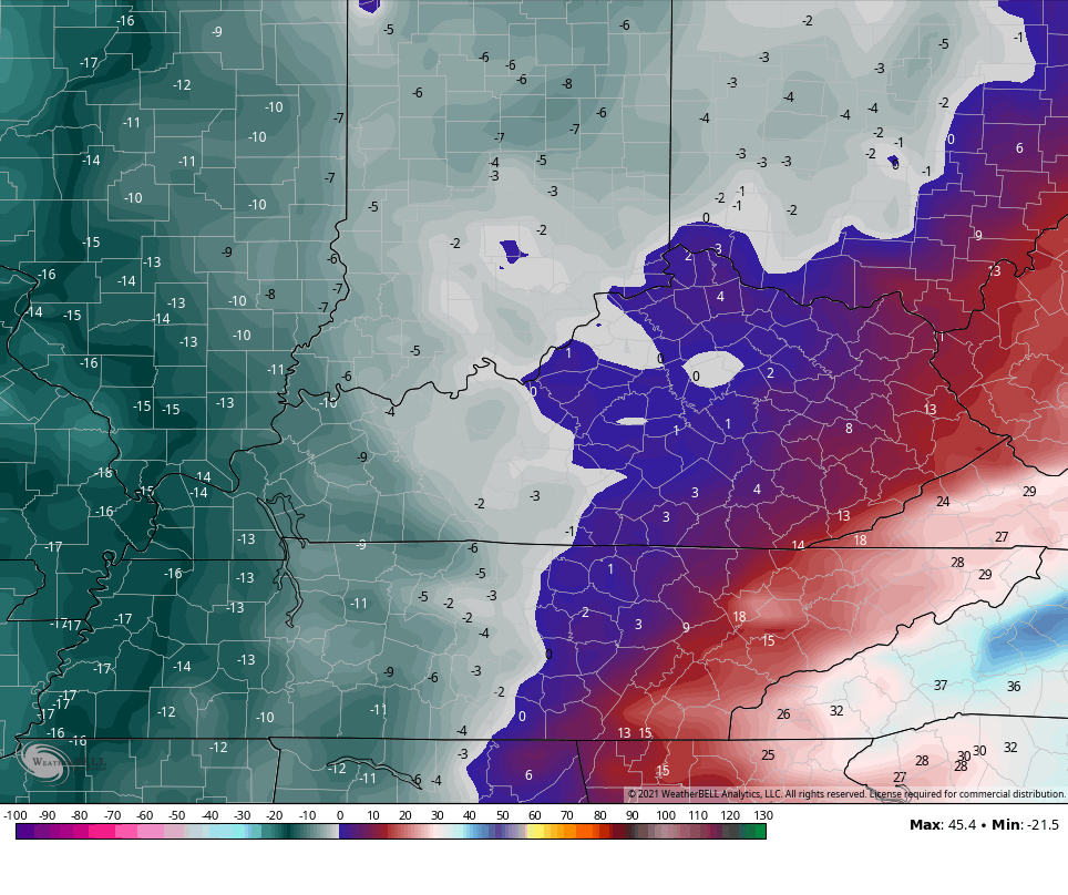
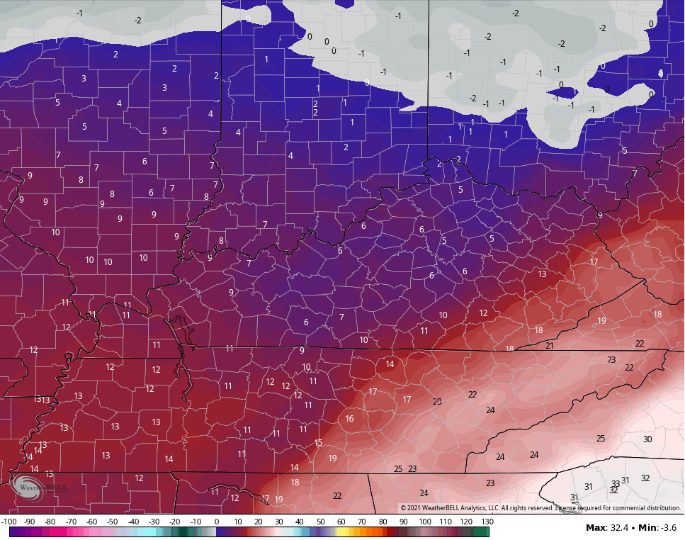
Areas of eastern and southeastern Kentucky continue to look at a full blown ice storm. This may even focus just a little more to the west. Areas of central Kentucky are in the battle zone between heavy snow, heavy sleet and freezing rain. The more these three fight it out, the lower the snow totals get, obviously. Not a single thing about the whole forecast in the buffer zone is comfortable as far as the forecast goes, but here ya are…
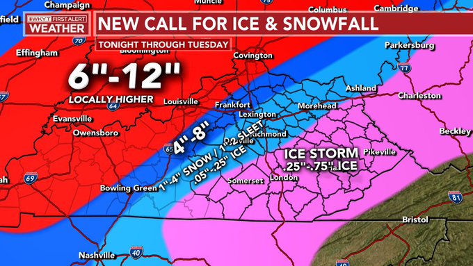
It wouldn’t take very much at all for the Lexington area and central Kentucky to wind up with much more snow or much more ice. We are walking a super fine line and I will adjust that map as needed on the fly today. We are nowcasting, folks.
Regardless of precipitation types, this is a shutdown storm for the entire region. That’s already the case to start the day for some, but the worst comes later today and tonight. Power outages are likely to become widespread and trees may also come down.
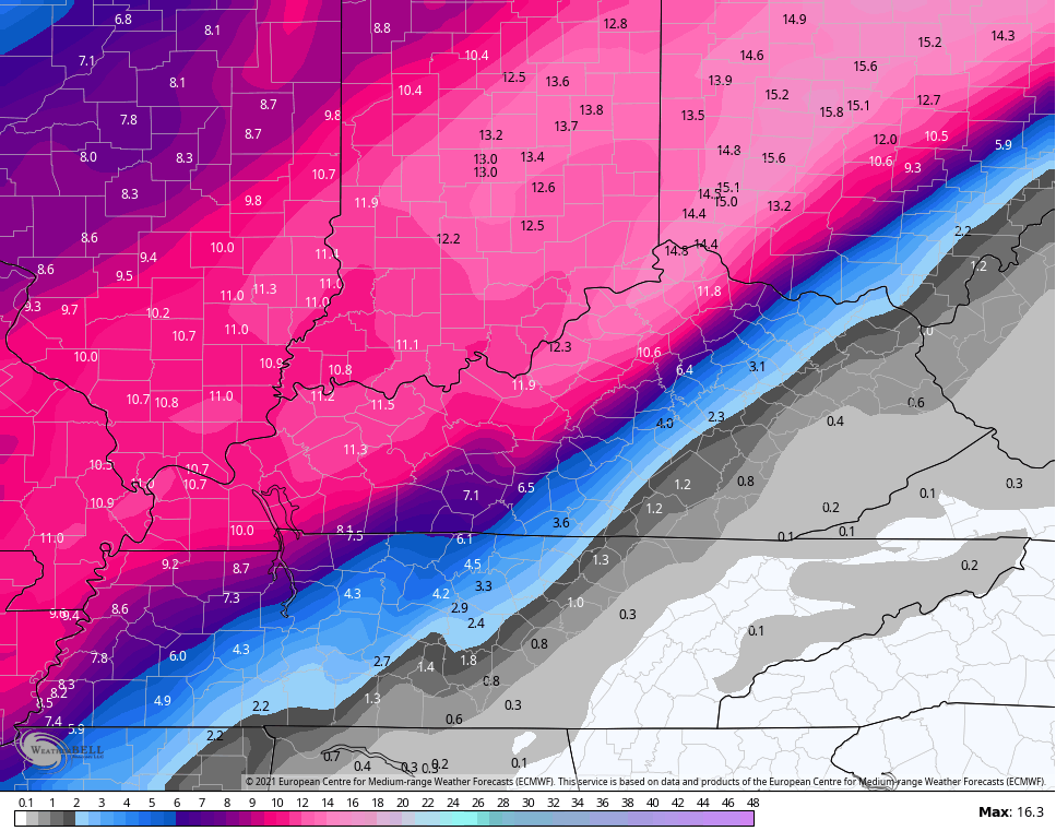
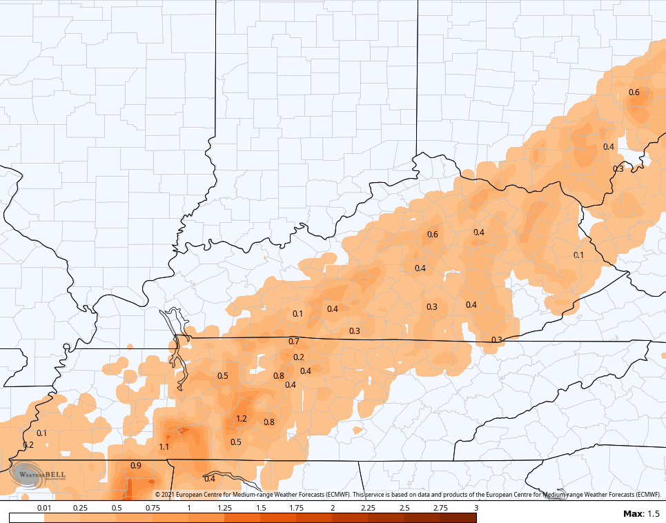
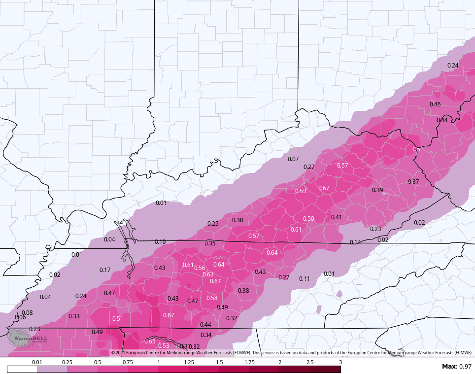
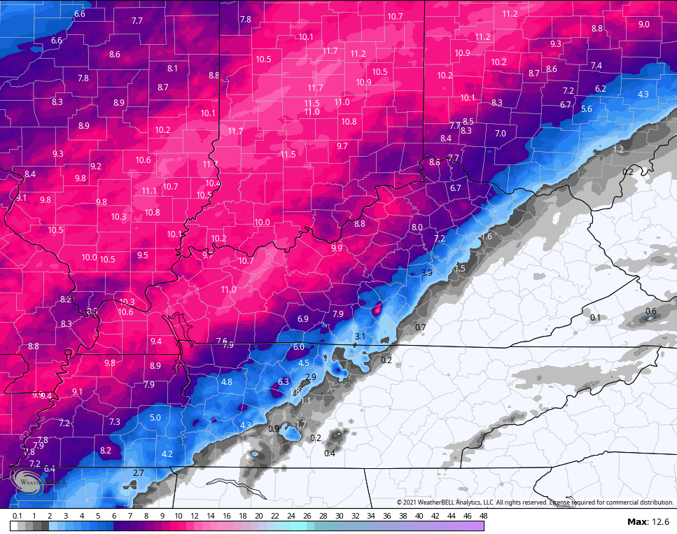
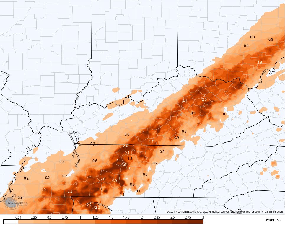
In terms of the models, the EURO and HRRR seem to have handled the onset of the first wave. Here’s what they show for totals through Tuesday…
EURO SNOW
EURO SLEET
EURO FREEZING RAIN
HRRR SNOW
HRRR SLEET
HRRR FREEZING RAIN
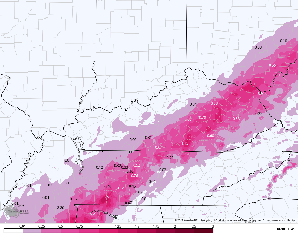
That much ice will bring devastation with it.
Arctic cold air accompanies this storm with winds that may gust to 30mph at times late today. Lows by Tuesday morning may go below zero across western Kentucky…
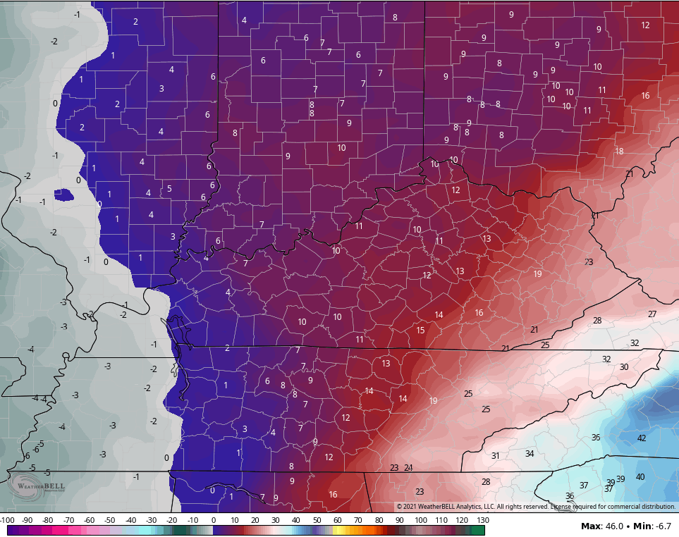
Wind chills could reach the danger category…
Wednesday morning lows may also approach zero in many areas of the state…
The Winter Storm THREAT continues from late Wednesday through Friday. This storm will also bring significant amounts of snow, sleet and freezing rain.
EURO
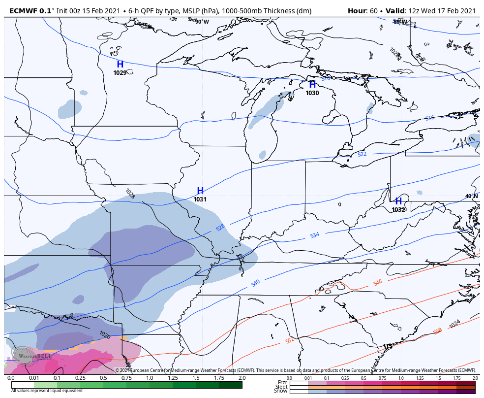
GFS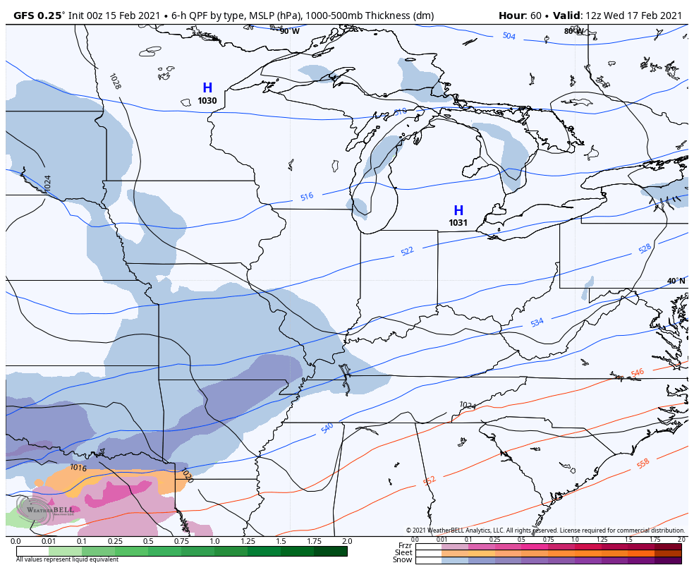
Temps behind that will once again threaten the zero mark. If that winds up producing more freezing rain, I don’t have the words to convey how much damage it would cause.
I will have updates later as we nowcast the storm. Here are your radars to follow the first wave out of the region and to track the big daddy into the region…

Have a great day, stay safe and take care.

Thankfully looking like plain rain for South Williamson, KY. Shifted way west in the last 24hrs.
Winter Storm Warnings are now in effect for most of the Chicago Metro Area until Tuesday morning, as the system snow keeps moving further and further north with each run, according to the NWS. Lake effect snow will enhance the totals in Chicago and near Lake Michigan. 8 to 13 inches of snow are predicted for Chicago and the Cook County suburbs, while 5 to 9 inches are predicted for the West and SW suburbs.
It’s currently 0 degrees out, with a wind chill of 19 below with light snow.
Sunday’s high of 4 degrees at Chicago’s O’Hare Airport was the coldest high temperature ever recorded for Chicago on Valentine’s Day. The low of 5 below was just six degrees away from the record low.
Mike, It Doesn’t Look Good For My County Of Taylor. The Only Natural Occurrence That Might Save Us If The Cold Arctic Air Would Move Farther South And East Overtake The Warm Air Aloft.
It’s 20 Degrees Now And Early this Morning We Had A Dusting Of Light Snow Which Has Ended. I Was Hoping That Would Be It, But After Looking at The Radar There Is A Lot Of Moisture Moving Toward Us From The Southwest.
The Freezing Rain Line Has moved Farther North. The Heavy Snowstorm Has Moved Into Central And Southern Indiana Where Several Inches Of snow Is Expected.
Take Care And don’t Get Too Cold And most Of all Be Glad You Are not In Kentucky. One more Thing The Lake Effect Snows Have always Fascinated Me Even Though I’ve Never Experience The Event.
Wow Chris, You Sure Have Been Busy With This Awful Winter Weather And We Thank You big Time For All Your Updates. You Have Provided The Most Information Of any Weather Site !
Seems we may need to hope for more sleet if ice is the main thing, since the models have been trending N-NW with the snow for the past 24 hours now. They got closer in and now see a big icy fence for a lot of Kentucky. Biggest snow chances in over five years and bleh.
Still a Dumb & Dumber chance? The next event would probably follow whatever this does for the most part.
The “Fence” You Speak Of Is The North Edge Of The Southeast Ridge.
The southeast ridge lives in the Atlantic
Correct, But It Moves East And West From Time to Time.
The Proper Name Is The Bermuda High Pressure system.
Bitter cold here 10 degrees and the snow is knocking on our door. Have a safe and good day.
So disappointed. Went from 8 to 12 of snow to 1-4 with ice. Best of luck with this crazy storm. Stay safe!
NAM was right. Looking more ice and sleet. Sad thing is the second system will likely parrot whatever this is. Warm air laughs at the cold air over KY.