Good late morning, everyone. Our major winter storm is increasing from southwest to northeast and the setup is taking a turn toward the worst case scenario as more ice shows up. This increases the potential for widespread power outages across areas of central and eastern Kentucky. Farther west, it’s a shutdown snowstorm for the rest of the state.
I’m about to head into WKYT, but wanted to drop by for a super quick update with how things stand. This is a rough estimate of how this big storm looks to play out…
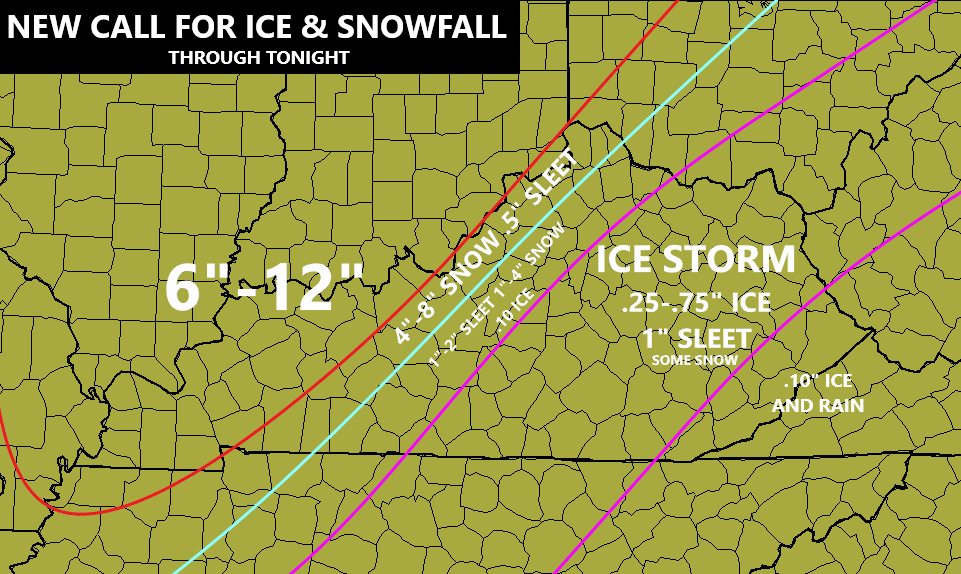
If you’re in the area I’ve outlined for the ice storm, make plans now in case you lose power later today or tonight. You can see how the buffer zone has moved west as well. I know many of you are looking at your thermometer that’s in the teens and low 20s and wondering how on earth this is happening. A warm layer of air is overrunning the low-level arctic air, creating all kinds of precipitation types.
The setup behind this is for the next winter storm to move in here by Wednesday and Thursday with significant freezing rain, sleet and snow.
Nothing good can come from the current trend of the week.
I will be on WKYT here in a while and be there until this storm is finished and will update KWC later. Here are your radars to follow this monster storm…

Have a good one and take care.

Why can Bowling Green not ever be in the sweet spot.. North South, East, West. Always around us!
I feel your pain Beckt
Well this just sucks! 12″ of snow to mostly sleet & ice ..uggh
Just like everyone else that’s replied, Becky, I am not in the best of moods w/ this storm. Nelson Co/Bardstown DID look to be in a good spot for, at least, quite a bit of snow. Now, it’s sleeting to beat the band after our little 1-inch snow earlier, and I don’t even know why I am griping and complaining, because this seems to be a habit for our location. In past possible snowstorms(other than 94, and I think in 2015??!), we were always in the zone for the big snow, but that would always end up about 10 miles north/NW/NE/E /W of us and we’d get the ALL ICE set-up. And the next storm looks to be “playing twinsies” w/ this storm, so I may as well just hush! LOL! 🙂
When Did Any Part Of Central Kentucky Ever Get A Real Snow ? I Consider A Real Snowstorm At Lease 18 Inches. My Guess About 200 Years Ago. lol
Dang, this could be historic in a bad way. Figured we were in trouble yesterday morning , since the warm air already proved itself once and the models we creeping west, as they got more data.
It just keeps getting worse and worse. 20 degrees and freezing rain? Unbelievable historical snows in areas that seldom ever get any sno double digit snows this fits right in with 2021 doesnt it? Lol
Just inched above freezing here so looks like we will stay rain for the rest of the event,
GFS drops several inches of heavy snow and then flooding rains for the next storm coming Thursday.
Would anyone know when this is supposed to start hitting central Ky.? Thank you
We Have Freezing Drizzle Here In Taylor County Now After receiving A Dusting Of Very Light Snow Early This Morning.
In about an hour the main stuff should be starting.
33 and rain in South Williamson
I’m just amateurishly looking at the national radar. The slug of moisture coming through today looks heavy, but to me, (at least looking at the radar) it doesn’t look like a long duration. For example, it looks like it’s near coming to an end in Memphis as I type this. I guess based on that and the speed it looks like this slug of moisture is moving, maybe it won’t be a long duration?
Wow Chris, Thanks For the Mid Morning Update ! Watching the big Snowstorm Heading For Southwest Indiana.
Reminds Me Of all The Big Snows Of The Past 70 years While Living There.
And I Have Seen Many.
But None Here In Kentucky In the past Twelve Years That Were Very Impressive.
Will We Ever Receive A Major Snowstorms (18 to 24 Inches) In Taylor County ?
I doubt It. Our Best chance Was Today And tonight, But I am Glad For the Areas That Are Receiving Snow And Sad for the Areas That are About to Receive An Ice storm.
We Can Only Pray That The Coming Ice Storms Won’t Do That Much Damage Like The One In 2009.
Hoping For A Sunny And Warmer Next Week To End This Winter And begin Spring.
Say what you want to about the Nam.The first to latch on to the NW shift even though it was less than 24hrs.Not complaining at all,don’t want no part of Ice but been a headache trying to prepare for weeks without power and now 2 systems basically changed less than 24hrs out.Hard to take models seriously anymore.
Weather Models Cannot Keep Up With Fast Changing Weather We Are now Experiencing.
I am riding the NAM the rest of the winter season.
All the main models were showing some margin of NW shift, but were less than the NAM. Point is the last event was ice and sleet, so proved the warm air is dominant. Factor in the models showing a trend NW, seemed evident snow was a lesser player.
Heavy snow falling here in Union Co.. We finally bust the dome here.
Yes, finally!!
Glad You finally Broke the Snow Drought. That’s Really A good Old Fashion Snowstorm In Union county, Kentucky. Reminds Me, One Of Many Big Snows In 1977 In Evansville, Indiana And On North to Chicago.
I am Here in Taylor County Waiting For A Month Long Power Failure. I Sure Hope It Warms Up this Weekend.
I’ve Giving Up On A Real Snow For Our Area. Just Too Close To that Southeast Ridge.
We are getting sleet here. Am I hearing this right , it doesn’t stick to things? We won’t loose power with sleet?
Yes. Sleet is the least destructive of all the types of winter precip. You want sleet and not frz rain. Of course, most of us want snow
Yes, but the problem lies in how the sleet falls. Sleet can be and IS slick(I’ve had experience, don’t let anyone tell you different.), but the way I understand for here in Nelson Co/Bardstown, it may come down as heavy sleet for a while, then heavy snow, then back to sleet, back to snow, and you’ve got those layers there…sleet alone usually won’t cause anything major, but if it melts on the roadway and the temps are able to freeze it, then therein lies your travel issues. I slammed my car into a ditch nose first just up the road from my home back in 1985-we had a sleet storm, if you will, around 2:30-3pm, and when I got off work at 4pm, roads were OK, sun was out, but then I got to that curvy steep shaded hill just before my house…..yikes! It had melted, but turned into a sheet of ice. I had to actually get on my hands and knees and CRAWL across the main highway to get traction so I could go to my neighbors’ and call for someone to pull my car out……I almost got creamed by a slop truck coming too fast into the straight stretch…
Here in Lincoln co. About 1/2” of sleet with significant freezing rain falling.
That looks like some serious ice or sleet showing up past Nashville heading into KY.
Heavy freezing rain in the Perry County area at this moment. I do hope the temperature rises above freezing before we have massive trees falling and power outages. I have heard of outages in the area already. They are bound to get worse with the amount of water that’s falling at 29-30 degrees.
I love winter. I love snow. It seems like maybe I need to move either north, west, or perhaps even *southwest*. We here in Fencetucky are not in the snow zone anymore.
Best wishes, and stay safe.
Suprise suprise the portion of WKY I live in MISSED OUT on the big snow thus far. Cant win for losing!
Yell, I heard that the snow totals in Owensboro have been disappointing.
The forecast was within 24 hours and was still missed due to mainly ice and sleet rather than snow for KY. Pretty big miss by the models it seems, but the trends were in place. NAM seems the main one to pay attention to for the next one, since similar. Models that show big snow are like moths being lured by flames in KY.
Seems it is going to be very hard to get out of the warm air factor for KY, so let’s wish for a speedy spring.
The GFS 10 Day Snow Accumulation Model Says There Will Be 18 Inches Of Snow On The Ground From Nashville To Lexington By The 25 Of February.
Talk About “Crying Wolf.”
NAM is the Jam for the next system. GFS and big snow = mirage.
For Fencetucky the GFS is a mirage for big snow.
Bubba – You’re a Madison Co. guy, if I remember…. It’s pouring with rain in my part of Richmond – how about you? And, it’s 29 degrees. That’s not good…….
Yep- ice rain. Waiting for power to go out again. What trips me out is the mets using hindsight and saying the warm air from the Gulf caused the warm air aloft….. OK- then why follow shiny models showing lot of snow? I warned about this for about two days now and the trend showed up not too long after that.
Goebbels Forecasting Service =GFS
A propaganda weather model.
We have a good coating of sleet on the ground and ice on the trees, but we have been lucky and kept our power on so we won’t freeze to death.
Next Storm looks warmer with rain and maybe flurries at the end ?
Still snowing here at Union.Co I’m guessing maybe 6- 8 inches of snow. It’s hard to tell with the drifting.
Well enjoy the Snow while you have it.
It may be a long time before you have another Snow.
I’m still waiting, but I got a feeling it will never happen.
Back home In Washington, Indiana It’s been Snowing much of the Day and they are closing in on a foot of Snow.
Since this pattern started they had all Snow and a lot of Snow and no Ice storms.
Snowstorms do occur in all parts of Kentucky, with the Southeastern part getting the most.
Western and Central Kentucky get the least.