Good Tuesday, everyone. The second winter storm in less than a week has come and gone and now we turn our attention toward one more set to arrive over the next few days. This storm will bring snow, sleet, freezing rain and some rain back into the region. Given the current state of the Commonwealth, things can get ugly once again.
Our recent winter storm left a lot to be desired in the snow department, but the sleet and ice storm part of it more than made up for it. The ice storm was devastating across areas of southern and eastern Kentucky with well over a hundred thousand customers without power as of this writing. Trees continue to come down and have been blocking many roads and have even fallen on homes.
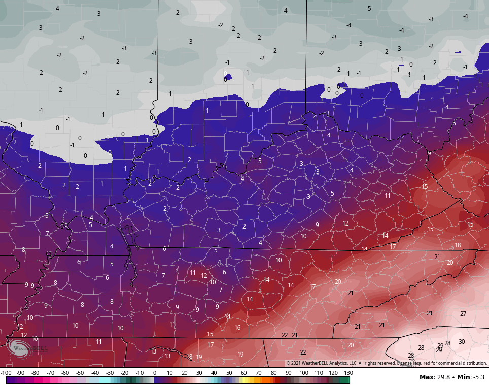
Roads are absolutely horrendous across the entire region and today won’t do a lot to help road crews out. Temps today may start out below zero across the western part of the state with wind chills even colder. Highs are only in the teens areawide with gusty winds making it feel like the single digits.
The sky will also throw some periods of light snow and snow showers at us and this may put down additional light accumulations. Here are your radars for the day…

Temps tonight drop into the single digits for most of the state and could even briefly dip below zero if skies clear in the north…
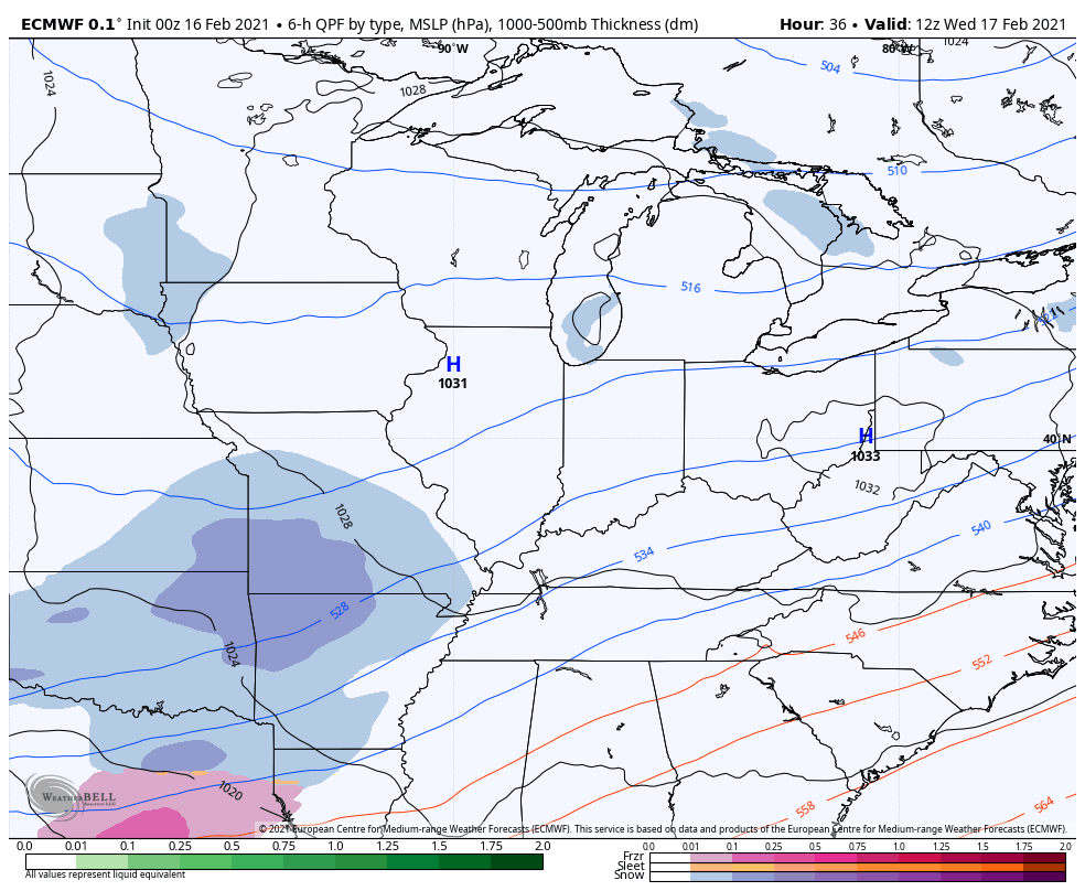
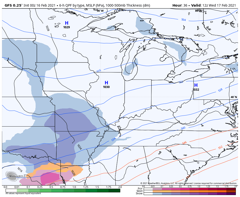
Our Winter Storm THREAT is with us starting late Wednesday and will be with us through early Friday. The first wave of snow moves in on Wednesday and should bring accumulations with it.
The main action then comes as low pressure works to our south and southeast on Thursday. This throws significant amounts of snow, sleet, freezing rain and some rain into the state. How much of each and where they wind up is a work in progress. The last storm shows how finicky these precipitation types can be.
Here’s how the models play this…
EURO
GFS
The NAM…

As this storm goes by, we see another shot of arctic cold for Friday with light snow.
I will have your normal updates later today, so check back. Have a good one and take care.

All of that sleet, and I think there was “some snow” and that that last slug of moisture was freezing rain which coated the top of the sleet and made it look like an ice skating rink. Since we had that first winter storm, there has been ZERO sun……..it’s no wonder it hasn’t gotten above freezing for days. I feel like the coldest month (January) isn’t the coldest month anymore. It’s now February.
For the first time ever, we have “sleet drifts” by my house…. covered by a thick layer of ice….
Glad no Snowmageddon. NAM rules so far. I was prepared for the worst so no harm no foul
Take care everyone.
Thanks Chris, for keeping us informed. We have Snow flurries currently, with a temperature of 12 degrees F. What fell yesterday was an on and off sleet event that didn’t amount to much. We were in the dry slot of the storm. Hence, nothing to write home about. Speaking of such, where I grew up in South Central Indiana, on top of 7 inches of Snow that fell in a previous storm, yesterday they added a foot of Snow to that total and no freezing rain either. I bet there are a lot of drifts around there to.
A hundred thousand homes without power and men and women out in this frigid weather repairing utility poles with tree limbs falling. I have to say God Bless them and keep them safe.
I don’t understand why we are still using utility poles and wires running through the trees is just asking for devastation in areas that have severe weather almost year round. This is 1880’s technology with telegraph wires for crying out loud.
This is the 21st century and it’s high time for a change on how electricity is supplied to millions of home owners. What that is or how it will be done I am sure can be accomplish somehow.
People and families are cold in there homes and this is 2021. Just doesn’t past the smell test.
Adding to the above I want to thank all the men and women that keep the roads clear and safe. These people are hard working and are risking their lives going out on ice and snow covered roads. God bless them and keep them safe.
How exactly do you propose we transfer the electrons? Saying this doesn’t “pass the smell test” feels like you think they let the outages happen on purpose. We have guys working day and night, 24/7 since last week, and will continue to do so until all the power is back on.
Does anyone know which model ended up being the most accurate with this storm?? Maybe then we can follow that model more closely today?
Yeah, that does make sense, But I think It’s better to use all weather models available.
We got 6-8 inches of snow here in Union.co. . I say most models were spot on for my neck of woods
Great, if we got that much Snow here and if I wasn’t crippled in my right leg and a lot younger I would be out building a Snowman. You don’t get rid of that kid in you ever.
You really need a somewhat wet Snow for building a Snowman though.
Gfs 12z https://www.pivotalweather.com/model.php?m=gfs&p=prateptype_cat&rh=2021021612&fh=54&r=conus&dpdt=&mc= GFSv16 https://www.pivotalweather.com/model.php?m=gfs_para&p=prateptype_cat&rh=2021021612&fh=54&r=conus&dpdt=&mc=