Good afternoon, everyone. It’s a bitterly cold day in the bluegrass state as areas of light snow and snow showers continue to put down light accumulations on top of all the ice and snow from our winter storm. There’s no rest for the weary as the third winter storm in a week is poised to move in late Wednesday and take us through Friday.
As of this writing, around 150,000 customers are without power across the region, especially in eastern Kentucky. With bitterly cold temps in place, this is a very dangerous setup for these folks as it’s going to take some time to get the juice back on. Tress, power lines and power poles are down across the region. To make matters worse, it’s still snowing. This snow is arctic in nature so it has little moisture and just blows around. That’s why you’re seeing snow falling outside your house, but you may not be seeing it on radar.
Still, I have your radars to follow along…

Temps tonight can drop below zero in several areas if we can get just a little bit of clearing.
Ok, let’s get to our next winter storm. To be honest, I’m just now trying to get a handle on how this system works out because the last storm nearly took me out. 😜
Significant amounts of snow and freezing rain are possible across the entire region, but the signal for sleet really isn’t showing up. The first round moves in Wednesday and is primarily light snow everywhere. The main part of the storm then expands in here Thursday with wraparound snow and bitter cold for Friday.
Let’s take a look at some of the latest model data:
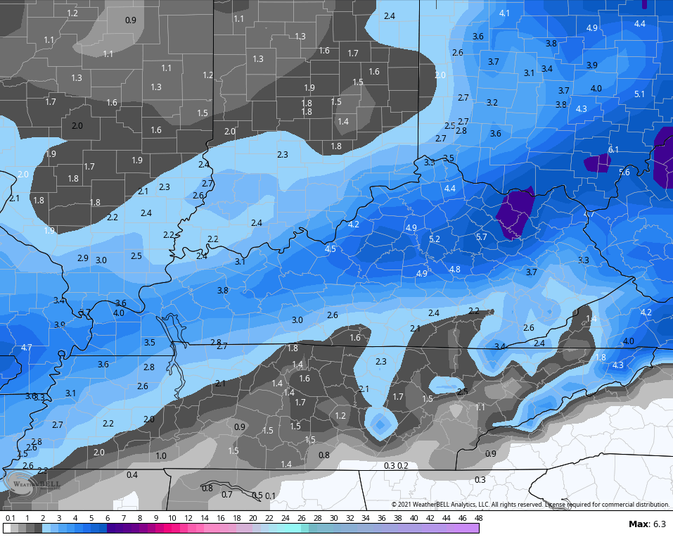
The NAM did a GREAT job with this last storm, but it only caught the trend of the storm within the last 24 hours before it started. We are just outside that window right now…
You can see how the model is bringing some plain rain into the southeast. Here’s the NAM SNOWFALL…
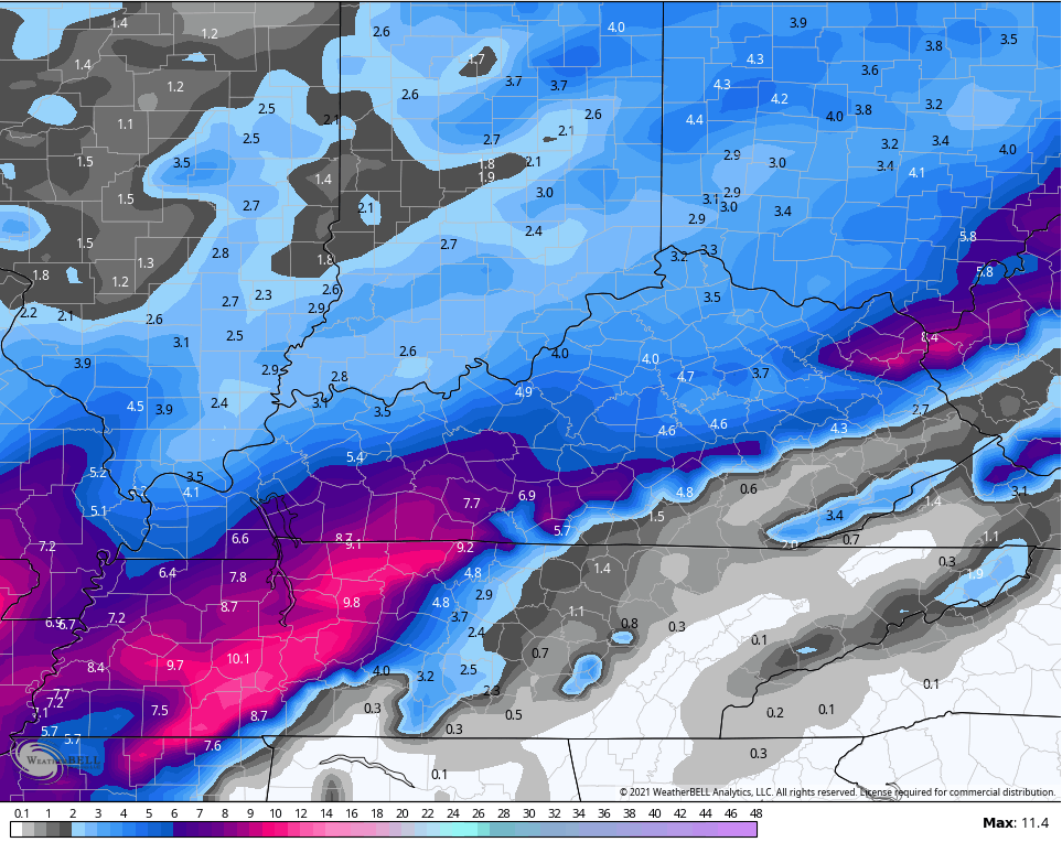
That looks way overcooked in the southwest into Tennessee, but who knows right now.
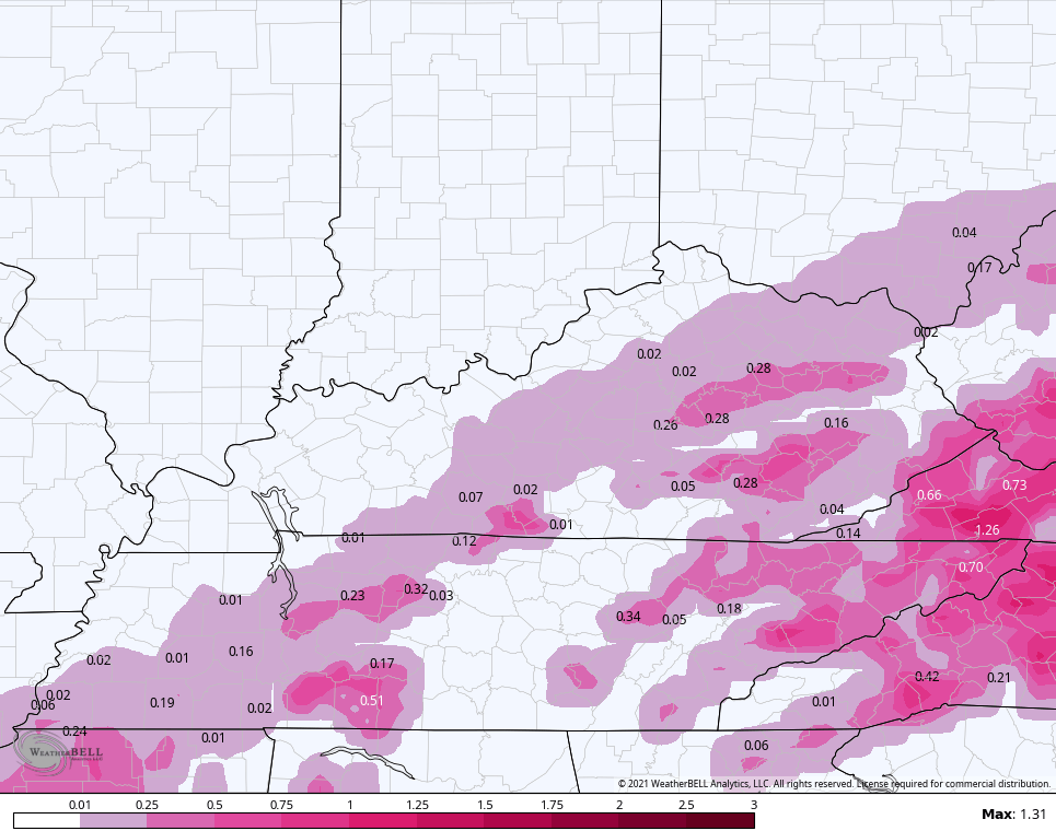
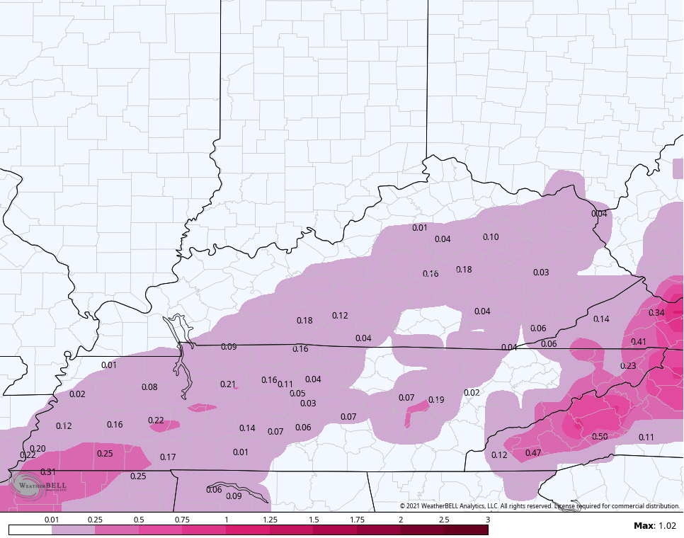
NAM FREEZING RAIN
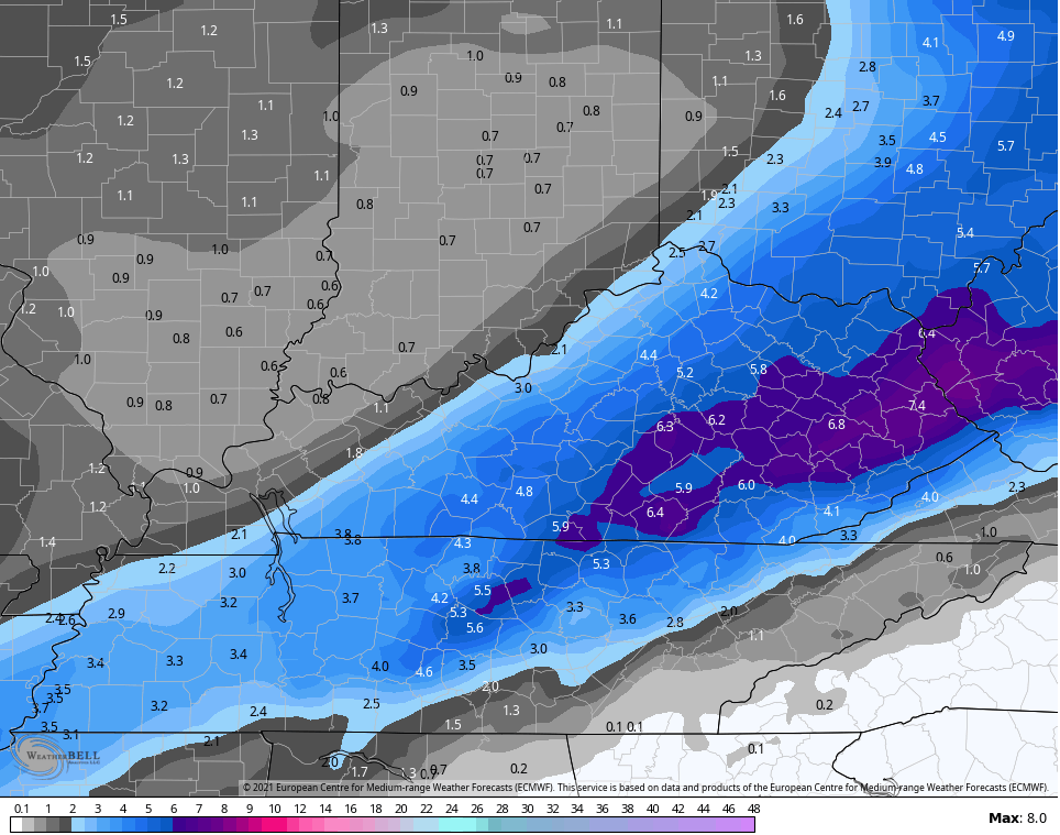
Here’s the GFS with a similar overall trend…
GFS SNOWFALL
GFS FREEZING RAIN
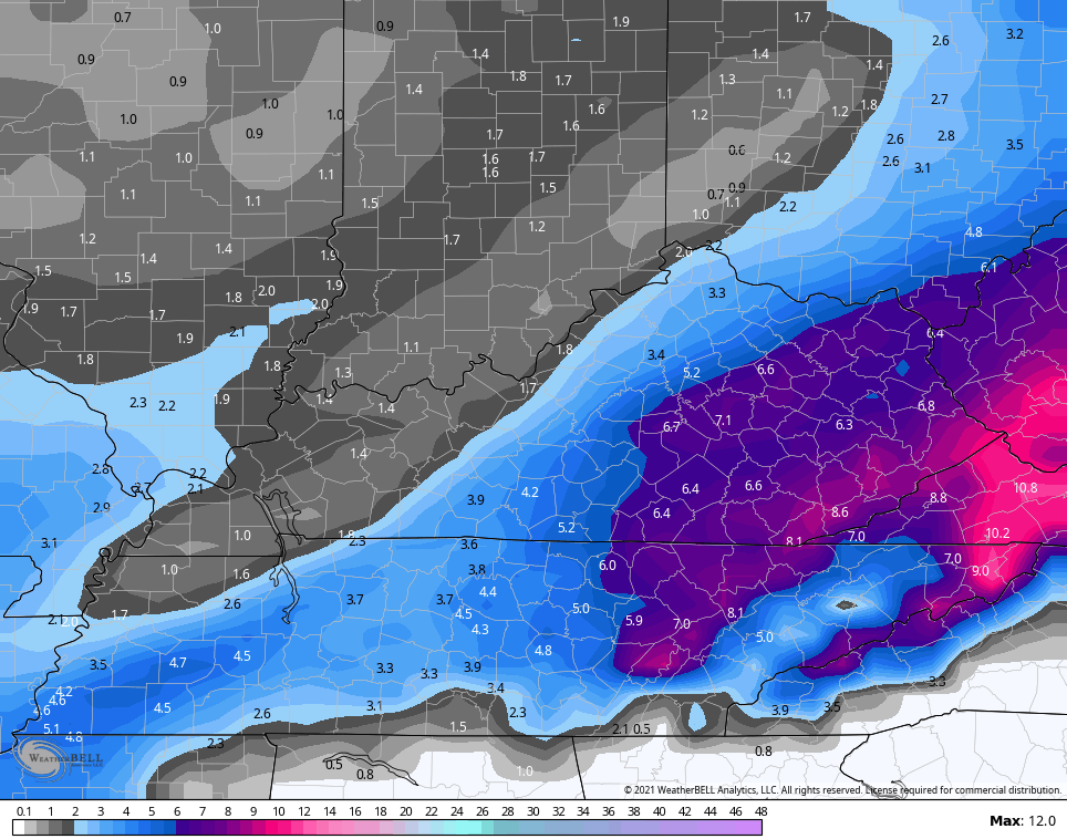
The new EURO comes out in a little but, but the overnight run had this storm being colder and farther southeast, giving more snow to the east…
The EURO has a friend in the new version of the GFS…
Normally, I would have a First Call map out by now, but I’m not putting my name on something I admittingly haven’t had the chance to fully dive into just yet. I will have the First Call For Ice and Snowfall coming up at 4pm on WKYT. That will then be here on KWC with the next update.
Stay warm and check on your neighbors on this bitterly cold day. Take care.

Thanks Chris for the update, I’m the kind of person that gets very upset when I here that many people all over the country that have no heat tonight. They need to deploy the military as this is a life threatening situation which in my opinion could be rectified by spending lots of money to upgrade the electrical power to a different way of providing power to all and not be affected by any disturbances from weather or electrical magnetic pause from Sun flares and other perils that may or not be natural.
I think the next storm will follow the same path as the last one. Uncertainty in precipitation type. How much and where the worse weather (Ice storm) will set up. I think Western Kentucky and Southwest Indiana will have the heaviest Snow amounts.
New euro still plasters the the SE
Probably smart. Warm air is probably awaiting to surprise yet again.
Agreed and have to say that i have zero faith in weather tech. We got 1.5″ of snow this morning in 30 minutes….yet the radar showed absolutely nothing. lol
Every time I’ve gone outside these last two days, a new type of precipitation was coming down. Very interesting, and my husband could see all of the layers as he dug out our car . I can’t imagine how you can predict all of that with any certainty, but Chris prepared us for this dangerous mix. Thankful in Lexington!
I think it will be all snow this time around. If it is, it will be our first decent snow in six years here in Taylor county.
Keep warm everyone. Very dangerous cold.
Power outages should be taken seriously.
A question I have, If people live in a very rural area and don’t have power where would they go with this pandemic ?
We have 9.5″ of snow on the ground here near Bloomington, IN after it snowed a total of 8.1″ from Sunday night through this morning. That made it my biggest snow in over 7 years and I finally got my first snow 5″+ snow in almost 6 years. It is absolutely beautiful seeing almost 10″ of snow on the ground and the piles of shoveled and plowed snow are 4-5 feet high along with drifts which are at least 2 feet deep themselves. I hope it sticks around for a bit and doesn’t melt off in a big rain that leads to flooding.
I see you guys are going to get some snow from this next one. It looks to miss us up here to the north for the most part, which is totally fine with me because we have plenty of it already. It’s that time of year now where I am ready for warm weather. Even though I love the snow I do not love the cold so at a certain point I get sick of it too.
My local forecast is predicting around 4 inches before all is said and done I just hope we don’t have freezing rain and sleet mixing in cutting down on the snowfall totals.
Yesterday we were close to getting up to 7 inches, but the warm air aloft took the chances away. In extreme Western Kentucky they received up to 8 inches of Snow.
In Washington, Indiana and up to Elnora, Indiana I read there was more than a foot of Snow fell yesterday on top of the 7 inches from a previous storm.
It has always been that way in South Central Indiana when it Snows it Snows Big and it’s usually one after the other.
Right now we have sleet with an inch of Snow on top and it is very dangerous because they have done nothing to the roads leading into town so we are snowbound or sleet bound till it melts.
Enjoy the Snow, but be careful advice from a former Hoosier.