Good Wednesday, everyone. Our third winter storm in the past week is set to impact the region starting later today and will take us through Thursday and early Friday. This looks more like a snow maker than anything else as the ice chance with this remains fairly low overall. Still, we are at a point where it won’t take much snow or ice to cause more power issues.
Here are some thoughts on how this plays out:
- This storm continues to feature more in the way of snow and less freezing rain, but there’s a little rain that may creep into the far southeast.
- Sleet isn’t an issue this time.
- The Thursday snows will be fairly wet and this is going to add to the weight of the ice already on trees. Additional trees may come down and we are likely to see more power outages.
- One wave of light snow works in from the southwest today and brings some light accumulations with it.
- The next wave of moisture moves in this evening into early Thursday and brings more widespread accumulations. Some of this may be in mix form across the southeast.
- After a weak lull around midday Thursday, the next wave of snow develops across the region and takes us into Thursday night.
- Snow showers and flurries will show up into Friday with additional light accumulations.
- Frigid temps will come in behind this as temps could make another run at 0 by Saturday morning.
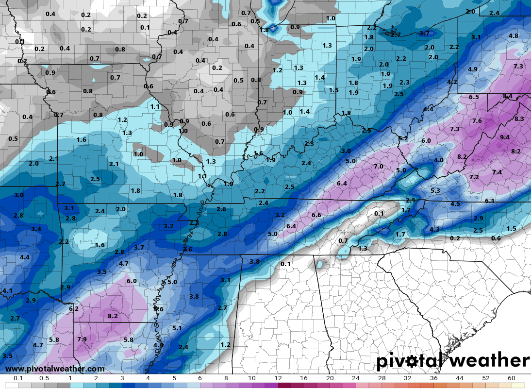
Here’s my New Call For Ice and Snowfall…
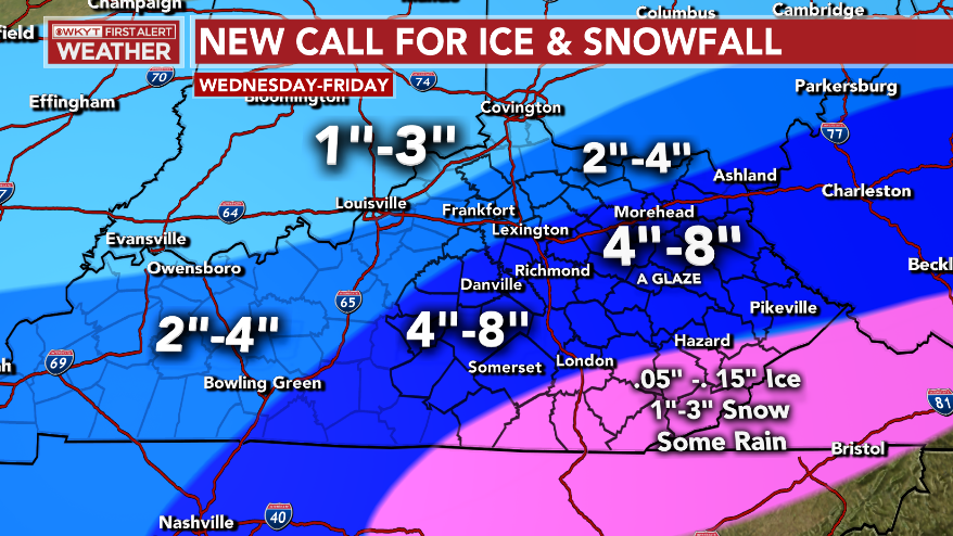
That map continues to be a work in progress today and the numbers and lines are likely to be adjusted as I see the early trends setting up.
A quick check of the models still gives us some notable differences in totals and placement.
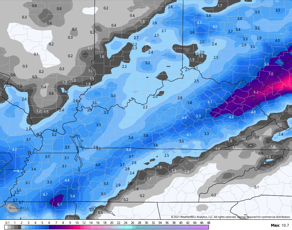
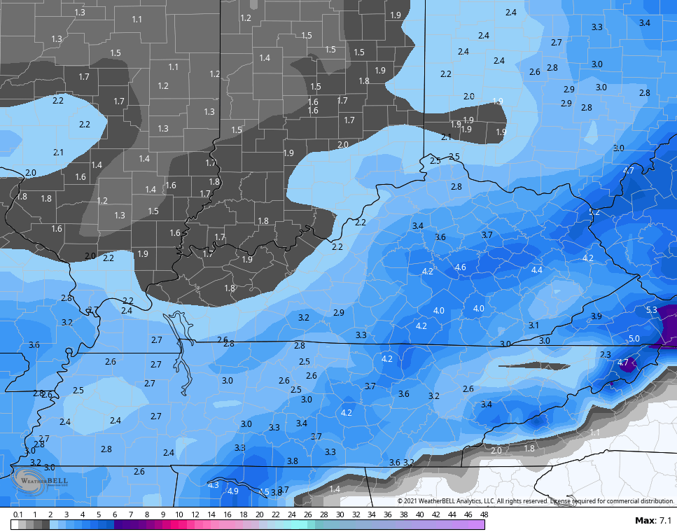
NAM SNOWFALL
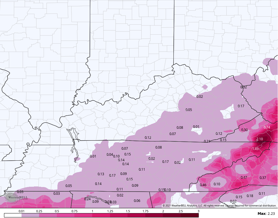
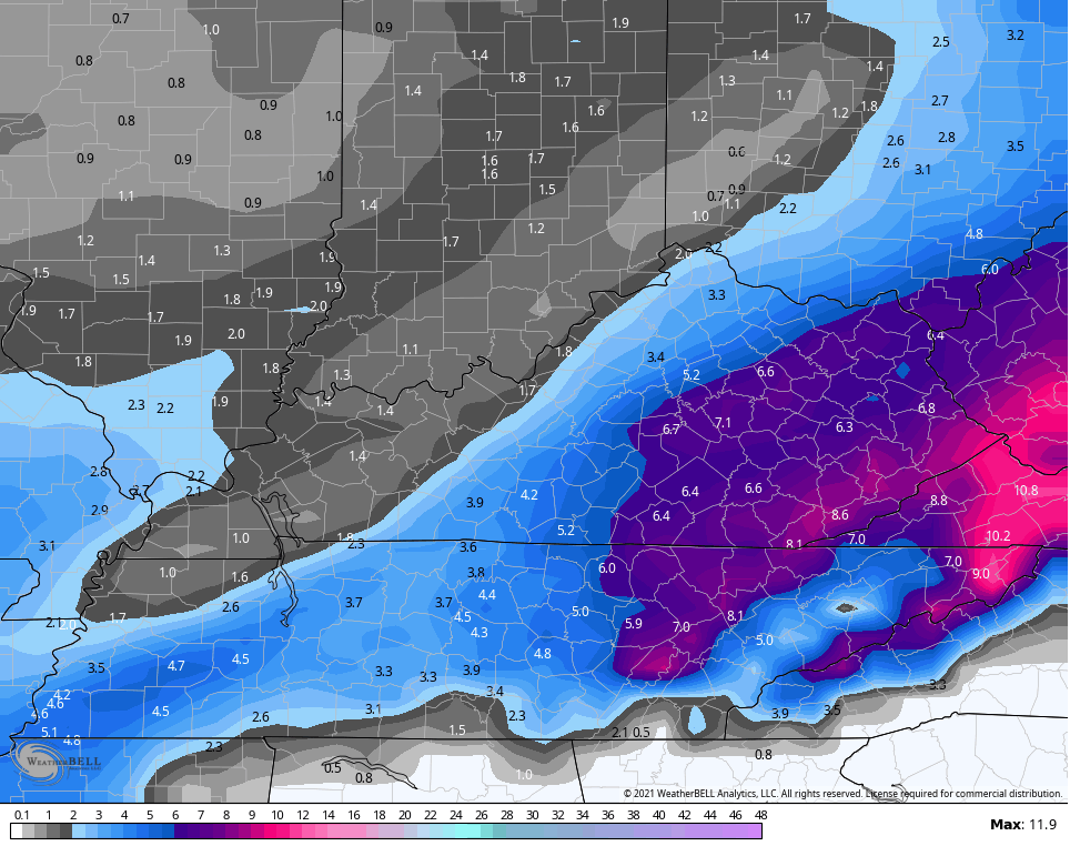
NAM FREEZING RAIN
HI RES NAM SNOWFALL
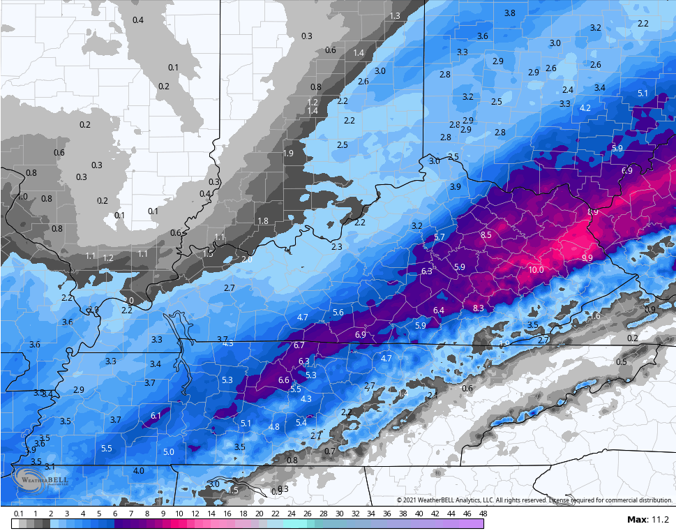
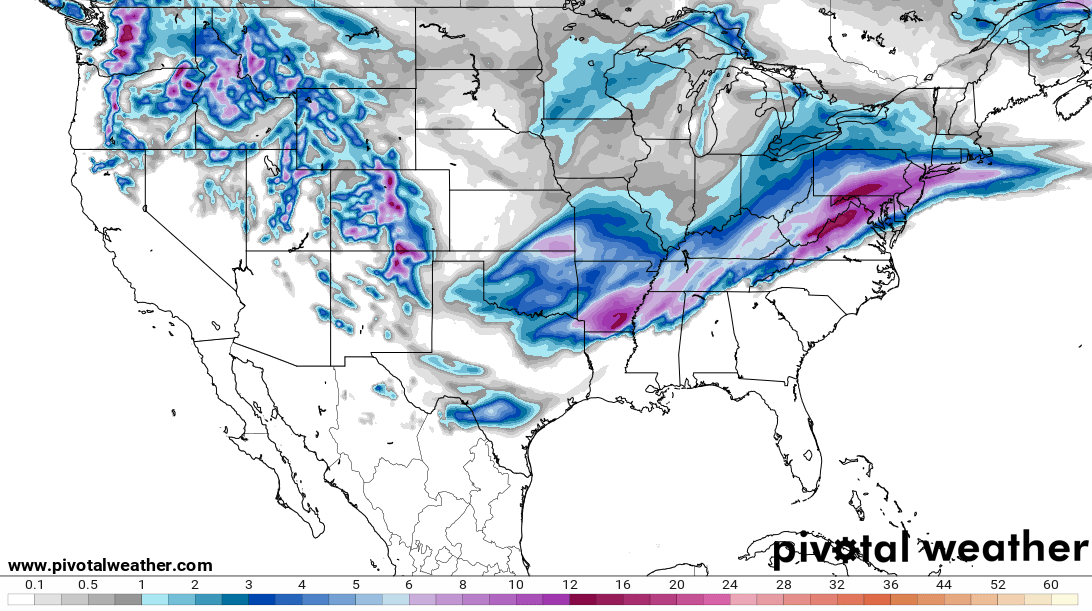
GFS SNOWFALL
GFS FREEZING RAIN

The new version of the GFS SNOWFALL…
The RAP SNOWFALL…
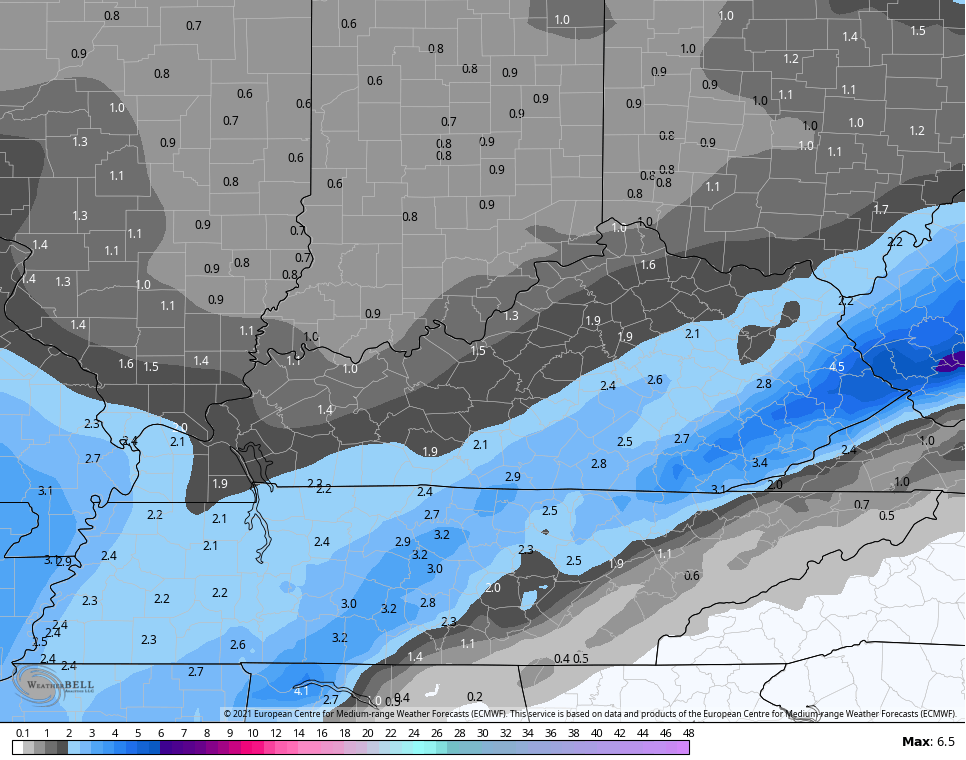
The EURO continues to come in on the light side…
UKMET SNOWFALL
So, you can see how we still have enough of a spread amongst the models to keep things a little edgy today.
Oh and let me say just how tired I am of posting model snow maps. This has been a long winter and I really haven’t slept for the past few weeks. As I always say, sleep is for the weather weak. 😫💪
I will have updates later today and should have a new call out around noon. I leave you with your radars to follow the storm in from the southwest…

Make it a great day and take care.

What is the difference between NAM and Hi Res Nam? Why do the other models not have Hi res versions? Just the NAM? I think of resolution as video quality…….
The Lake Michigan snow machine really targeted Chicago on Monday through early Tuesday with very heavy lake effect snow. Chicago’s Midway Airport received an incredible 17.7 inches! Meantime, Chicago’s O’Hare Airport, which is about five miles further inland than Midway Airport, received “only” 7.5 inches of snow. There’s now 24 inches of snow on the ground at Midway, and 21 inches at O’Hare. The 24 inches is the most snow that’s been on the ground since back in January-February 1979!
The NWS forecast office about 35 miles SW of Chicago received 7.8 inches, and where I’m located, about 40 miles SW of Chicago, I measured 4 inches before shoveling. There’s now around 15 inches of snow cover here.
From Jan. 26th through Feb. 15th, 34.1 inches of snow has fallen at O’Hare Airport, the snowiest three-week stretch since that brutal winter of 1978-79.
Here is a complete summary of the Heavy Snow Event from Feb. 14th through the 16th. http://weather.gov/lot/Feb14-16_HeavySnow
That’s interesting with the lake effect Snows.
Nothing here and I don’t expect any changes at this time.
Take care Mike and enjoy the Snow.
Mike – After a slow start, snow lovers in the Chicago area must be in good shape now. This is seeming more like the winters of my youth of the late 70s and early 80s. Even as a snow lover – in a couple of weeks I will be ready for spring…..
Thanks Chris for all your hard work !
All the late morning models are in pretty good agreement on the track with the exception on the NAM being somewhat north of all the rest. Don’t think the NAM solution will be correct this time around
and just after saying that, the NAM has now moved back south
https://www.tropicaltidbits.com/analysis/models/nam3km/2021021712/nam3km_asnow_neus_23.png
Yep, looks like the NAM has corrected towards all the other models.
NWS just bumped me up to 4-8 inches here. I’m guessing we will see some changes on Chris’ new snowfall map.
Jared, are we still up for the snow to change to rain and back to snow? Or are we all snow?
Looks like rain during the day Thursday but that could change of course.
Big difference between gfs and gfs para https://www.pivotalweather.com/model.php?m=gfs&p=snku_acc&rh=2021021712&fh=60&r=conus&dpdt=&mc= https://www.pivotalweather.com/model.php?m=gfs_para&p=snku_acc&rh=2021021712&fh=60&r=conus&dpdt=&mc=