Good Monday and welcome to the month of March. Torrential rains over the closing days of February continue to lead to major flooding issues as we kick off day one of Meteorological Spring. The high waters will continue for several more days along our rivers, even as the overall pattern dries out for a while.
Our rainfall is winding down early today, but the flooding remains, especially on the rivers and bigger creeks.
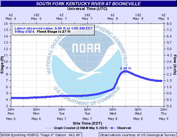
Here is a look at where we stand with current water levels and the forecast crests along some of these bigger waterways…


Here are your radars to follow the early day rain out of the state…

With the drying trend comes cooler temps as highs today generally reach the upper 40s to low 50s. This dry air likely hangs tough for much of the week, but there is the chance for a few showers to graze us late Tuesday and Wednesday.
From there, we will be seeing colder air coming in later in the week through the weekend. That will be followed by a blast of milder air into next week…
GFS Temp Departures

GFS Ensembles Temp Departures

With that warmer setup could come some more thunderstorm action. I’ll throw you guys another update later today.
Have a great Monday and take care.

After seven days in a row of temperatures of at least 40 degrees, including 52 degrees on Saturday which was the warmest day of the year, the massive snow cover here in the Chicago area has really eroded. Last Sunday, O’Hare Airport had 16 inches of snow on the ground, and today that number has gone down to just three inches, and two inches in the SW suburbs. By the end of this week, the remaining snow left will likely be gone, except for the massive piles from shoveling or plowing.
No measurable snow has fallen since last Sunday, and only a few-hundredths of an inch of rain has fallen since then, as the pattern has dramatically shifted from very cold and snowy to mild and dry.
We’re temporarily in the colder air for a day, as temps will be held to only the mid-30s. It’s a chilly early morning here, with temps in the mid-20s and wind chills in the mid-teens.
With no precipitation in the forecast for the next week, and much above normal temps predicted beyond that, it looks like it’s going to be a challenge to break 50 inches of snow for the season here. O’Hare so far has received 47 inches, and the NWS forecast office in the SW suburbs has had 46 inches.
The snow cover in the last week here in the Chicago area has gone from 16 inches at O’Hare Airport last Sunday to only 3 inches now, and 2 inches at the NWS forecast office in the SW suburbs.
That’s what seven days in a row with temps of 40 degrees or higher, including a 52-degree high on Saturday, will do. Also, no measurable snow and very little rain fell here this last week.
In the last 48 hours we received 6.13 inches of rain. I pray for those who live in the flood prong river and creek valleys, and at the same time I’m glad I live in these foot hills.
Mike, I notice on the Ventusky weather site that Arctic Air has entered the north central states, so I wouldn’t put the snow shovel away just yet. That may be the weather case here to.
That Arctic air isn’t going very far south, Schroeder. It’s currently confined to Northern Minnesota, where it’s currently 3 degrees at International Falls, and Eastern North Dakota.
We’re seeing modified Arctic Air in the Chicago area today, as it’s a chilly 32 degrees here with a NW wind bringing the wind chill down to the lower 20s. But after a cold night tonight down in the teens, temperatures are forecast to be in the 40s throughout the Chicago area for the next six days with no snow or rain.
By the end of the week, the little remaining snow cover here should be gone except for the massive piles that were shoveled or plowed.
That Arctic Air isn’t going very far south, Schroeder. It’s currently confined to Northern Minnesota, where it’s 3 degrees at International Falls, and Eastern North Dakota.
After a cold night tonight in the teens here in the Chicago area, it’s predicted to be in the 40s for the next six days with no snow or rain.
I just got done visiting the Ventusky Site and the Arctic Air is predicted to move East and stay North of the US border over the next few days and I’m wondering now if Northern New England will get the frigid Arctic Air and Snow this weekend.
We are suppose to get colder this coming week with mostly dry weather. It will be nice to see Sunshine, but this time of the year Winter weather could be a surprise factor.