Good Tuesday, everyone. It’s a MUCH calmer pattern taking shape across Kentucky and much of the country. This pattern is exactly what the weather doctor prescribed for our flooding woes that continue in many areas. Overall, the next week or so skews colder than normal to go along with the dry.
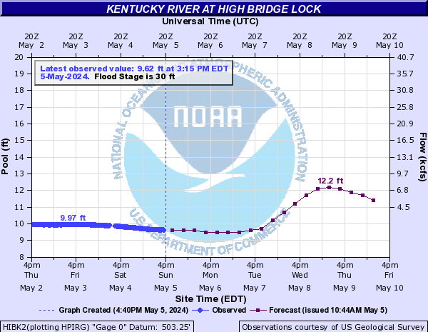
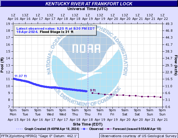
Flooding continues along many rivers across Kentucky. The river of most concern right now is the Kentucky River with a crest flirting with all-time records farther downstream…


The weather looks really good out there today with highs mainly in the 40s with plenty of sun.
Wednesday looks even better as temps jump…

A cold front drops in by Thursday and brings temps a little colder than normal for the end of the week into the weekend. Still, our skies look dry and should feature plenty of sunshine. The setup into next week should feature a flip to above normal temps as seen on the GFS Ensembles…

As you know, meteorological spring is underway and that means meteorological winter is finished. It was a cold and snowy winter around here…
The winter of 2020/21 (Dec-Feb) ends as Lexington's coldest since 2014/15. The average temp during this time was 33.4 which is 1.8 degrees below normal. Rainfall was 1.61" above normal at 11.94". Snowfall to date is 9.5" above normal with 20.8". #kywx
— Chris Bailey (@Kentuckyweather) March 2, 2021
That doesn’t mean we are done with snow and typically get March snows to add to the overall totals. Here’s hoping that’s not the case this year. #TeamSpring
Have a great day and take care.

longer daylight hours, temps increasing, plentiful sunshine ….. thank goodness winter is nearly over! #TeamSpring forever 🙂
I would like to see a couple of March thunder Snows before I join #teamspring. In my area we had more rain and ice than Snow, but the last Snow was around 7 inches. Not too bad for this Snow Lover.
Glad we are going to continue the Sunny days and cooler nights over the next 7 days. We don’t want the plant life to break dormancy too soon.
We want flowers and fruit to be plentiful this Spring and Summer.