Good Wednesday, everyone. It’s another very warm day across the Commonwealth, but this time it comes with a few thunderstorms going up. There’s the chance for a few strong to severe storms from late afternoon into tonight with another low-end risk for Thursday. This may be a signal of things to come as we head into the first full week of May.
Temps today range from the upper 70s to low 80s with a gusty southwest wind and clouds on the increase. A few storms develop this afternoon, but the concern is for a few strong to severe storm clusters to develop this evening into the wee hours of Thursday.
Here’s the area the Storm Prediction Center has outlined for a low risk for severe weather…

This risk focuses a little farther to the east on Thursday…

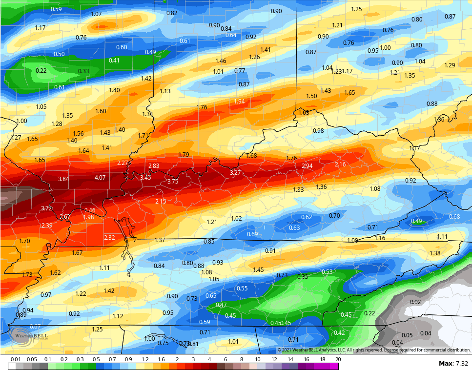
Damaging winds and large hail are the main players, but we will also have to watch the local flash flood threat. A corridor of 2″-4″ rains may try to set up somewhere across our region. Parts of the state are under a Flash Flood Watch across, but some of the models are south of where the initial watch is…
GFS
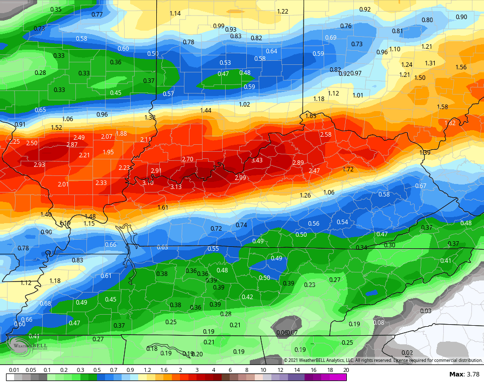
CANADIAN
This action clears out for a cooler Kentucky Oaks Day with temps in the 60s for many. Kentucky Derby Day is looking warmer now with temps upper 30s to low 40s to start and low and middle 70s during the afternoon. Derby Day will be a winner.
Temps spike to around 80 by Sunday and into early next week as humidity enters the mix for the first time this spring. The resulting pattern should turn stormy with rounds of thunderstorms a good bet…

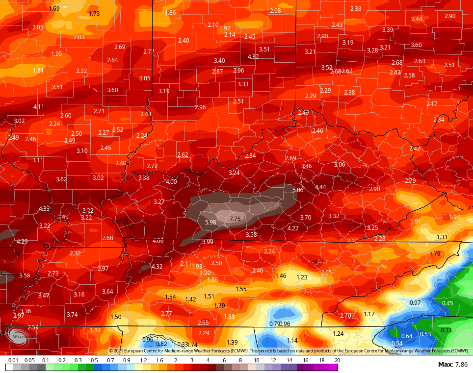
The EURO isn’t shy with rainfall totals through the middle of next week…
 I will have updates as needed. As always, I leave you with your storm tracking tools…

Current watches

Possible Watch Areas

Have a great Wednesday and take care.

Under sunny skies and strong S to SW winds on Tuesday, the high temperature of 87 degrees at O’Hare Airport tied the all-time record high for the date set back in 1986, and was the warmest temp since early September.
A wind shift front passed through Chicago shortly after sunset shifting winds to the NE off Lake Michigan, and as a result the temperature dropped 20 degrees in just five minutes at O’Hare Airport!
That front has remained stationary this early morning, as the temps are still near 70 degrees here in the SW suburbs but only near 50 degrees at O’Hare. That front will go through the entire area later today.
Much needed rainfall is on the way also for the Chicago area, as there hasn’t been any measurable rain since April 11th and only 2/3 of an inch of rain has fallen the entire month at O’Hare (1.10 inches in the SW suburbs). According to the US Drought Monitor, most of the Chicago Metro Area is experiencing moderate drought conditions.
Under sunny skies and strong S to SW winds across the Chicago area on Tuesday, the high temperature of 87 degrees at O’Hare Airport tied the all-time record high for the date set back in 1986.
A wind-shift front passed through Chicago shortly after sunset around 8 PM, with winds shifting to the NE off the chilly Lake Michigan waters, dropping the temperature by 20 degrees in just five minutes at O’Hare Airport!
Under sunny skies and strong S to SW winds on Tuesday, the high temperature of 87 degrees at Chicago’s O’Hare Airport tied the record high for the date set back in 1986.
A front passed through shortly after sunset, with winds turning to the NE off the chilly Lake Michigan waters, dropping temps by 20 degrees in just five minutes at Chicago’s O’Hare Airport!
Under sunny skies and strong S to SW winds on Tuesday, the high temperature of 87 degrees at Chicago’s O’Hare Airport tied the all-time record high for the date set back in 1986.
1986, was the beginning of a series of long hot, very dry Summers.
81 degrees for the second time this Spring in my part of the World.
I don’t like to here the word humidity enter the forecast along with all the rain and storms that may be coming.
A week ago I was waking up to a half inch of Snow.