Good Sunday, folks. It’s an absolutely gorgeous day across Kentucky, but a stormy setup is on the way later tonight into the first half of the new week. This will be highlighted by the increasing risk for severe thunderstorms late Monday through Tuesday.
Temps out there today make a run at 80 in many areas as southwest winds kick in. This is ahead of a surge of unstable air pushing in from the southwest ahead of a plains storm system. As this moves in, showers and storms begin to develop in the west later this afternoon and evening. That will overspread the state into tonight.
As the plains low moves closer to us, instability really increases as we move into Monday and Monday night. This has the looks of our first fairly widespread severe weather event of what has been another super quiet spring.
The Storm Prediction Center has much of the region in the increasing risk for severe storms Monday…

Here’s the threat for Tuesday…

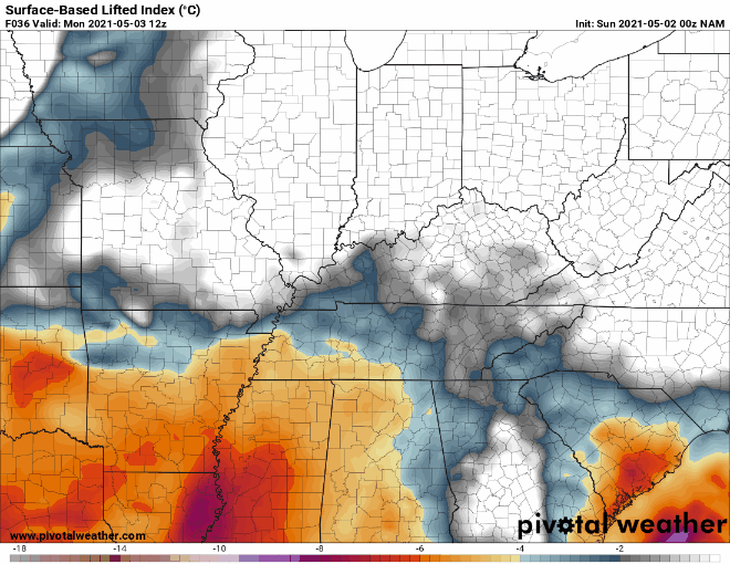
Many of the severe weather parameters are truly elevated for this first time this year. The Lifted Index forecast from the NAM shows a tremendous amount of instability…
Damaging winds, large hail and a few tornadoes would be possible with storms going up from Monday afternoon through Tuesday afternoon.
The setup behind this continues to be toward a chillier scenario into Mother’s Day Weekend…

Frosty cold temps are possible with that setup…

Warmer air fights back in very quickly early the following week and that’s likely to setup another stormy look with potential severe weather.
I may drop by for another update late today. Until then, here are your radars to track the increase in thunderstorms across western Kentucky…

Have a great day and take care.

Thanks Chris for showing the CAPE for Monday and Tuesday. It’s concerning that the j/kg is forecast to go over 1000 in Central and Eastern Kentucky for late Monday into Tuesday.
Absolutely perfect weather yesterday for the Kentucky Derby.
Everyone that attended looked very happy. Nice to see.
Have a great day everyone!