Good Monday to one and all. It’s been a super quiet spring severe weather season across Kentucky, but Mother Nature is trying to shake things up over the next few days. A potent setup may fire off rounds of strong to severe storms from this afternoon through Tuesday.
Here’s a breakdown of how things may play out:
- Showers and a few thunderstorms rumble through the region early today, but the severe threat is fairly low.
- Skies become partly sunny this afternoon as temps and humidity levels climb.
- At the same time, thunderstorms are developing to our west and southwest and will threaten western Kentucky this afternoon and evening.
- Rounds of strong to severe storms will then threaten the rest of the state tonight through Tuesday evening.
- Damaging winds, large hail and a few tornadoes will be possible in this type of a setup.
- Any storm out there will also be able to produce tremendous amounts of rain, leading to the potential for another round of local flash flooding.
The Storm Prediction Center has the entire region in the Severe Weather Outlook today…

That threat then continues through Tuesday…

Showers and storms wind down Tuesday night into Wednesday with cooler and drier air filtering in from the northwest. That’s ahead of a stronger system dropping in by the end of the week…

That has another blast of chill with it, but the models are a little faster in getting it out of here on Mother’s Day Weekend. Unfortunately, that’s likely to set up another very stormy look into much of next week.
The models aren’t shy with the rainfall totals over the next few weeks and the EURO Ensembles are showing the above normal rains…
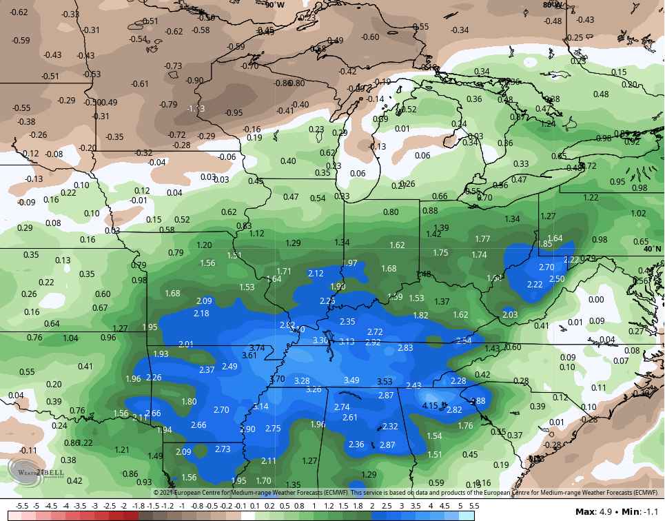
The Control run…

I may drop by for an update if needed and will have the latest on WKYT-TV starting at 4pm. I leave you with your Monday storm tracker tools…

Current watches

Possible Watch Areas

Make it a great day and take care.

Chris
You are the best. Keep doing what you are doing. You are above and beyond. Thank you for your passion.
All the best
Michael