Good Tuesday, folks. It’s another day of tracking rounds of strong to severe storms across the region. This comes on the heels of severe storms that hammered parts of the state on Monday and this looks like a sign of things to come as we go through the rest of the month.
Today’s storms come at us in clusters with damaging winds, large hail and a few tornadoes possible. The Storm Prediction Center continues to highlight the entire area in the Severe Weather Outlook…

In addition to the severe potential, torrential rains will continue to cause local flash flood issues to develop.
Showers taper off from west to east Wednesday as cooler and drier winds take hold. Highs are only in the 60s. Another system drops in here with a few showers and storms late Thursday…

That ushers in a very cool setup for the end of the week into the start of the weekend. Morning lows may drop into the 30s at some point.
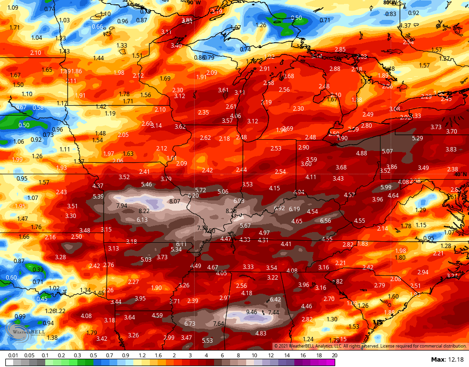
As warmer air moves in by Sunday into early next week, it sets up a very stormy and wet pattern for our region. The GFS rainfall numbers through next week show this well…
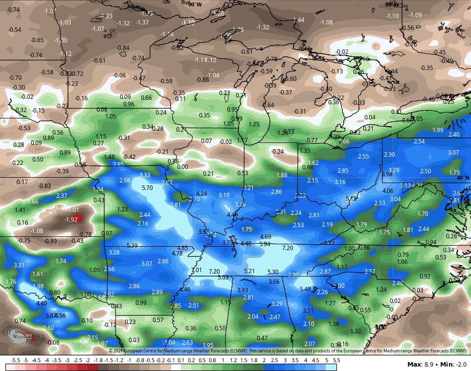
The EURO Ensembles show the above normal numbers…
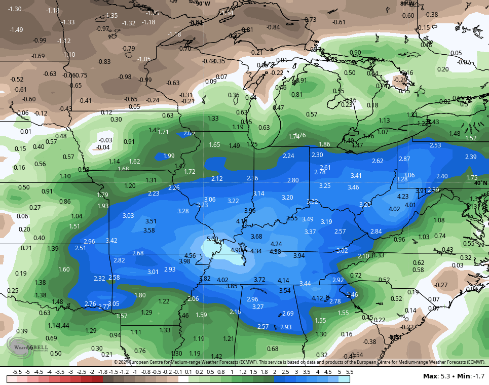
If we look deeper down the road courtesy of the EURO Weeklies, we find this very wet pattern showing up through the middle of June…
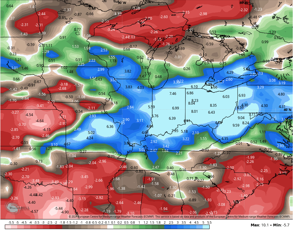
The Control run of the EURO Weeklies…
The more things change, the more they stay the same. 😉
I will have updates as needed and be on WKYT-TV during any breaking severe weather. I leave you with the Tuesday edition of your storm tracking toys…

Current watches

Possible Watch Areas

Make it a great day and take care.

The Chicago Metro Area is currently in a moderate drought, according to the US Drought Monitor’s latest update, which is no surprise considering that this April saw only 0.71 inches of rain at O’Hare Airport and was the sixth driest April in Chicago weather history. In the SW Suburbs there was only a little over an inch of rain for the month. Since March 1st, only 1.97 inches of precipitation has fallen, compared to the normal value of 6.23 inches.
April was also a warmer than normal month overall. The average temperature at O’Hare was 51.9 degrees, 3.0 degrees per day above normal, thanks to the very warm days at the beginning and end of the month. We’ve already had five days in the 80s this year.
Thunderstorm has now gone through without much fanfare. Expect another round later this afternoon and finally ending hopefully by midnight.
Rain is falling currently and have pickup a little over an inch in the last 48 hours.
April here was a cold month with one inch of Snow on the 20th day of the month.
Hope we do not have a wet, nasty Summer.
We are currently in a severe thunderstorm. About to loose power !
Schroeder, where are you located. I am in Mercer county ( Burgin)
Schroeder, where are you located. I am in Mercer county ( Burgin)
More bark than bite on the thunderstorm that pass through my county of Taylor early this morning. Rain however is beginning to pick up. A little more than an inch has fallen in the last 48 hours.
April here seemed to be colder than normal for my area of Kentucky with an inch of Snow on the 20th day of the month. The latest I have seen measurable Snowfall since I’ve been living here( thirteen years.)
Hope we do not have all that rain and storms through June. That would completely ruin our Summer.
The SPC has really become unreliable with their ability to target areas for Severe weather. Just yesterday, that had a big chunk of Kentucky in the Enhanced risk and most of the state in a Slight risk, simply not much of anything even panned out. Now we have this massive amount of rain in Central KY headed for Eastern KY and not even as much as a Flash Flood watch for them from the Local NWS… What’s going on over there?
Northern Taylor County