Good Thursday and welcome to July. Another month has come and gone as 2021 keeps rolling along, seemingly, faster than it should. The new month is starting with rounds of heavy rain producing showers and storms that may cause a few issues. These storms usher in a cooler setup into the holiday weekend.
A Flash Flood Watch is out through tonight across parts of the state. Rounds of storms will be common today and these will put down torrential rainfall and may do so in west-east streaks. Within these streaks, 1″-3″ of rain can fall in a short amount of time, leading to flash flooding.
Here are your radars to follow along…

Showers and storms will exit the southeast early Friday as an awesome air mass moves in from the northwest. Skies become partly to mostly sunny with low humidity and highs in the 70s. This sets the stage for temps to flirt with record lows by Saturday morning. Lows reach the low and middle 50s…

Yes that’s showing upper 40s in the far southeast. Wow.
The rest of Saturday looks nice with temps in the 70s for many. The 4th of July starts in the 50s and ends with temps generally 80-85.
It’s the time of year where the tropics start having a big impact on the overall pattern across the country. The National Hurricane Center is tracking two systems and one of them has become a Tropical Depression. This should get a name today and will work quickly through the Caribbean and may threaten Florida by early next week…

The GFS has been consistently showing this thing working northward along the Gulf Coast of Florida then up the eastern seaboard…
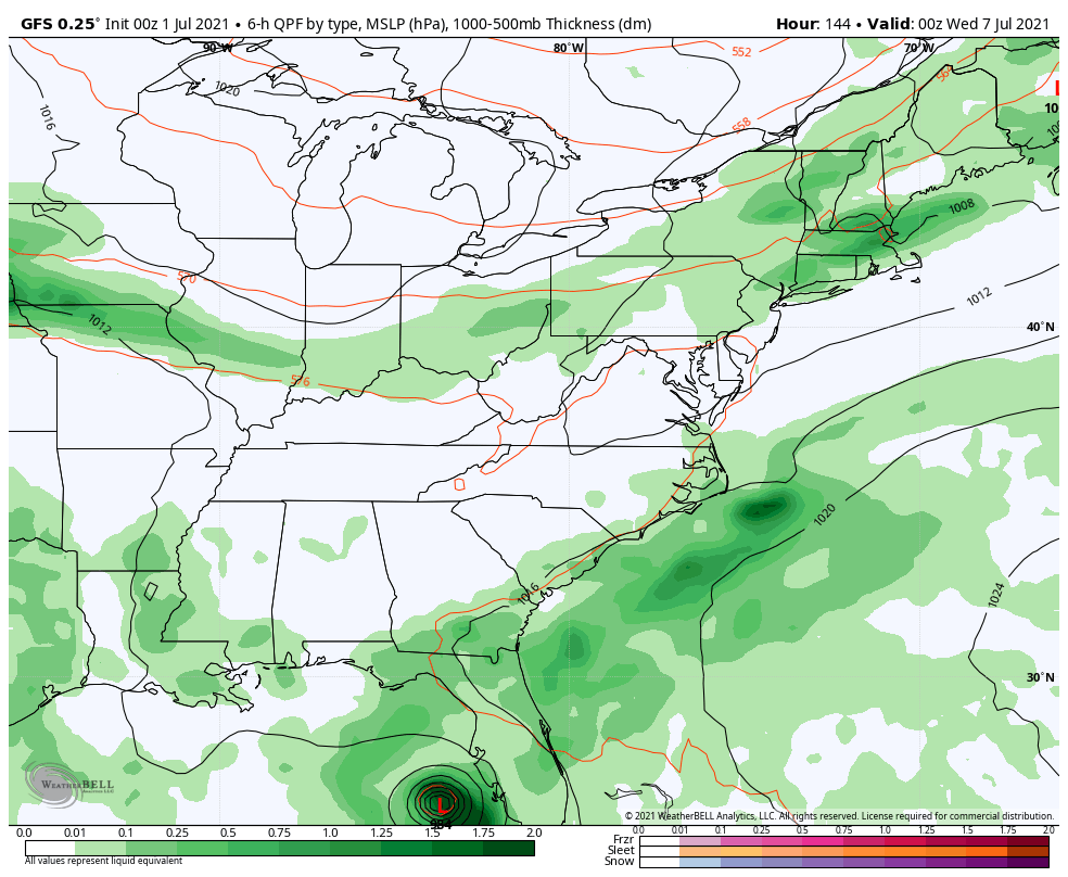
Odds are small for this storm directly impacting our weather as a couple of cold fronts sweep through here and deflect this to our east.
Make it a great day and take care.

Thanks, Chris! Lovin’ this weather – hot but not too hot for summer time with heavy rain every couple of weeks. You’re on a roll! Keep it up!
The 2020-2021 snow season has come to an end as of today. Here are how the numbers shook out for some of the sites around the region:
Cincinnati: Normal snowfall 23.3″. Observed snowfall 32.0″
Lexington: Normal snowfall 14.5″. Observed snowfall 21.7″
Louisville: Normal snowfall 13.4″. Observed snowfall 19.4″
Jackson: Normal snowfall 23.4″. Observed snowfall 28.6″
Here’s to lower totals in 2021-2022.
Also looking forward to cooler and drier weather this upcoming weekend. Especially the drier part.
We had below normal Snowfall this past Winter here in Taylor County. Precipitation was mostly ice.
Chicago’s O’Hare Airport wound up with 48.8 inches, compared with the normal of 38.4 inches. All but 1.8 inches fell before February 22nd.
Last snow season, only 34.8 inches of snow was recorded at O’Hare.
I’ve been living here for 13 years and I can only remember two Winters where the Snowfall total was over the normal.
If we have another La Nina Winter I’m going to give up on hoping for any major Snowstorms in my area of Kentucky.
Right now we are starting to receive some heavy off and on showers.
Dumped the rain gauge about fifteen minutes and I had 5.1 inches. There is more on the way! GLUB GLUB
Just over 4 inches on the SE side of Lexington and it’s raining again now.
We are missing most of the heavy rains here in Taylor County to our north.
The Kentucky Mesonet has measured only 0.01 inches of rain.
We may be in what I call a “pocket drought.”
Finally, after seven days in a row of measurable rainfall, the wet pattern has broken in the Chicago Metro Area. It’s a sunny, beautiful day with temps in the upper 70s and a steady breeze off Lake Michigan.
The 90’s will return here beginning on Sunday.
Yeah, cooler, drier air doesn’t last long, but I’m hoping we will have short breaks between the heat and humidity through the rest of the Summer.
The way Chris been talking the summer will have breaks of cooling off from the heat and humidity. Time will tell