Good Friday, everyone. We have a cold front dropping into the state today and it’s about to throw on the brakes. As the front stalls, waves of rain and thunderstorms will roll across the region starting late tonight and going through early next week. This sets the stage for heavy rainfall across much of Kentucky and the Ohio Valley.
The front is right on top of the state today and it takes the best chance for storms into southern Kentucky as the day wears on. This action will become scattered in this area as the rest of the state sees a drying sky. Here are your radars…

Some comfortable air gets in here for a time this afternoon and evening, so make sure to enjoy that!
The front becomes stationary tonight and that’s when rounds of showers and storms form to our northwest and push back in here. This is a trend likely to take us through the weekend into the first half of next week and could bring quite a bit of rain into the region…

It’s not raining all the time this weekend, so you will have dry times to get some outside activities in.
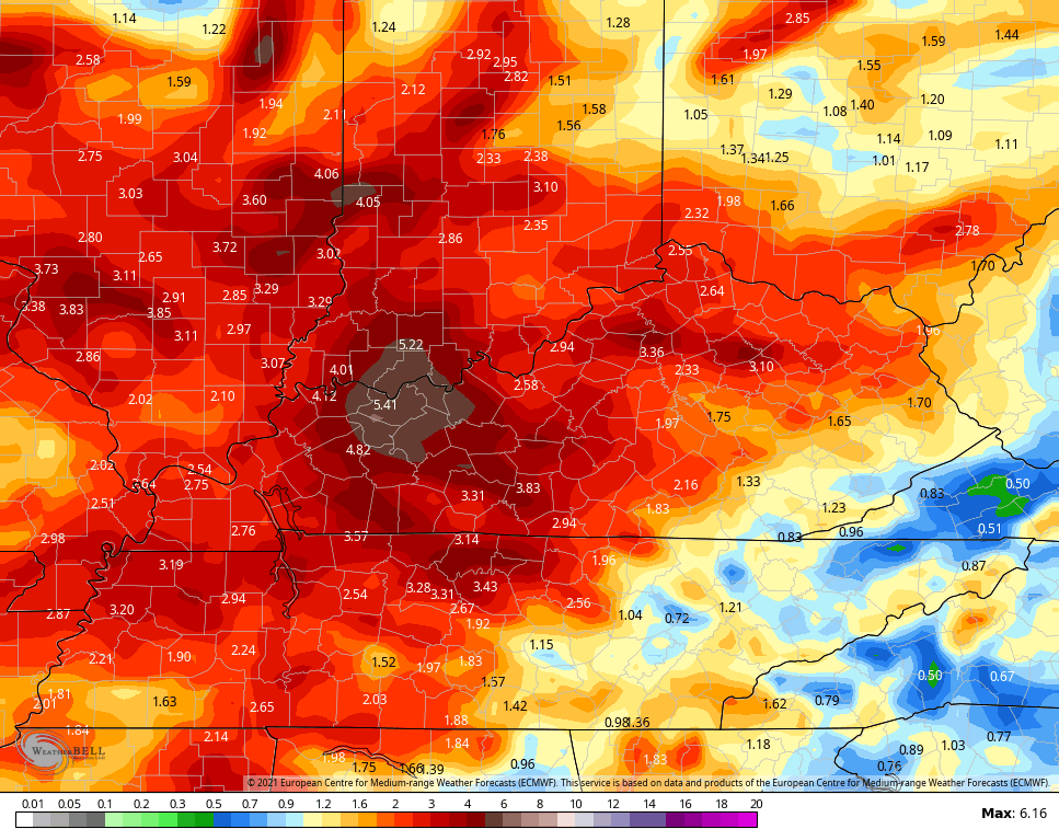
The EURO is spitting out some big time rain amounts during this time…
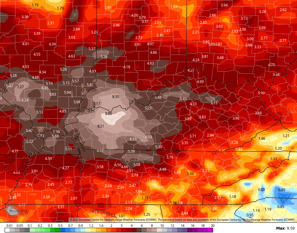
The model then keeps the storms coming through the end of next week into early the following weekend…

Here’s the EURO 10 day rainfall amounts through both of the above animations…
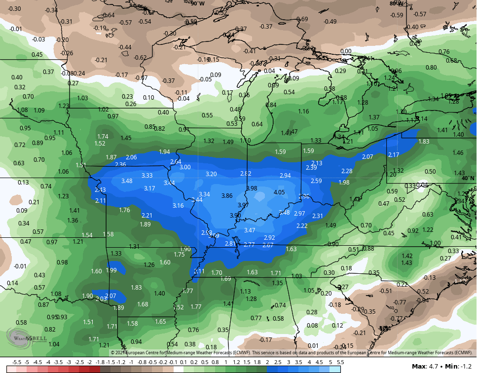
The model has support from the 51 member EURO Ensembles which show a supper wet period over the next few weeks…
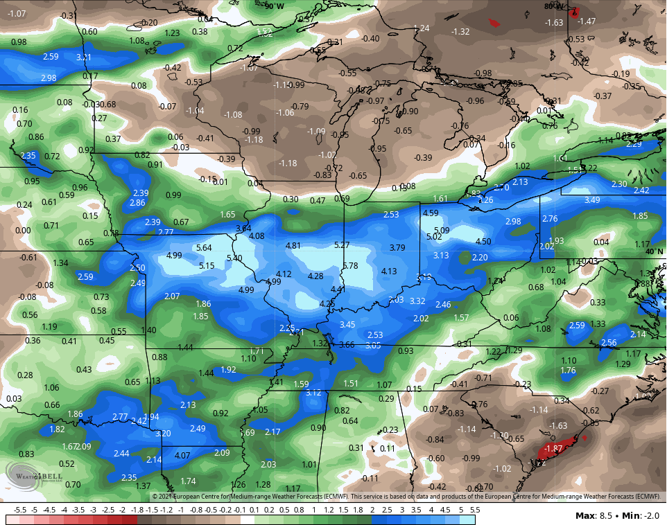
The Control run of the Ensembles show even higher above normal totals…
Make it a great day and take care.

As long I mow my yard at some point, it’s all good.
Mowed my “lawn” yesterday early as the morning dew was light. Been mostly cloudy here in central Kentucky. Still no rainfall to report. Maybe tomorrow ?
The last measurable rain at my PWS just south of Bowling Green was on July 1st, but nothing since, despite seeing storms on radar laying down sizeable precip amounts all around me. The storms are extremely localized; last night, the Mesonet site 2 miles from my location received over ½ inch of rain, while I saw only lightning in the distance. Hoping the stationary front produces, but I’m not holding my breath.
I’ve had enough with the rain this summer. I’ve had 17.05″ since June 1st here in south-central Indiana and my last rain was yesterday when I got 1.33″. I will gladly send some of this down south for you guys in Kentucky because I’m over it!
Good to here from home. We are getting to the point of being “abnormally dry.” Forecast calls for a 90% chance of rain showers Saturday with an approaching cold front late tomorrow afternoon. Until then the rain is going to “ride the ridge” as the Snow does in the Winter.
Temperatures in my area of Central Kentucky have been typical, but the humidity has been awful.