Good Tuesday, everybody. Rounds of showers and thunderstorms continue to target the region as our stormy week continues to do some work. Strong storms and heavy rains will be a threat today and, likely, through the rest of the week. At the same time, we are keeping close tabs on the tropics for a possible impact on our weather down the road.
Strong storms rumbled through here Monday and we will be on guard for more strong storms out there today. High winds, hail and torrential rains will all be possible from the storms that come in waves. Once again, the Storm Prediction Center has much of the region in a low-end risk for severe weather…

Any storm that goes up may be accompanied high winds, hail and torrential rains. These rains may cause some local high water issues. Outside of storms, temps are steamy!
The threat for a few more storms will be with us into Wednesday and we may also some booming storms go up once again, so keep that in mind. Temps will once again to run toasty with highs ranging from the middle 80s to low 90s, but the humidity will add to that.
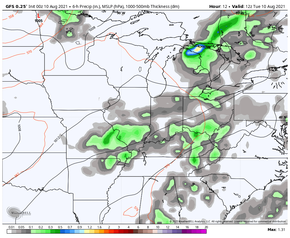
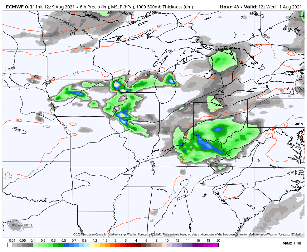
Thursday is likely to be a sauna of a day with just isolated storms around. That action picks up Friday as a cold front drops in from the northwest. Here’s how the models see things through Saturday…
GFS
EURO
While all this is happening, a tropical system is likely developing and heading toward Florida. Here’s our system in question…

The models vary on the track of this system from the weekend into early next week, but there is a good chance this has some kind of impact on our weather. Is it a direct impact or indirect? The GFS shows both…
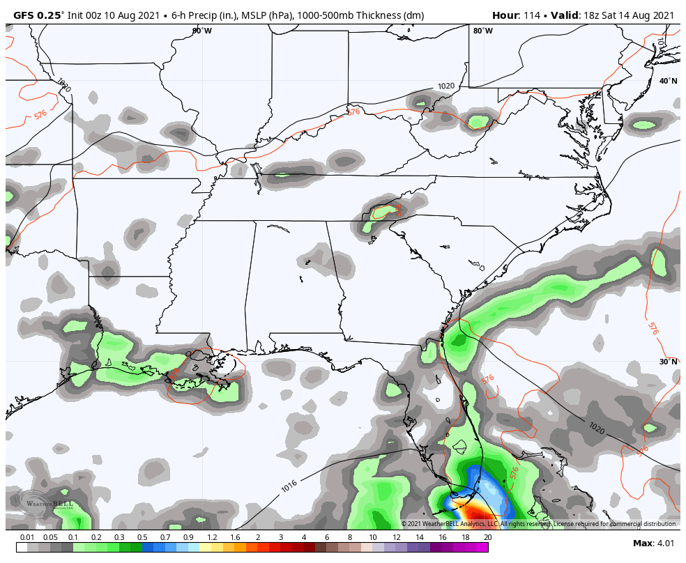
That run brings tropical moisture ahead of the remnant low moving right on top of us.
The EURO is a bit east of that with the whole track, but has a similar idea…
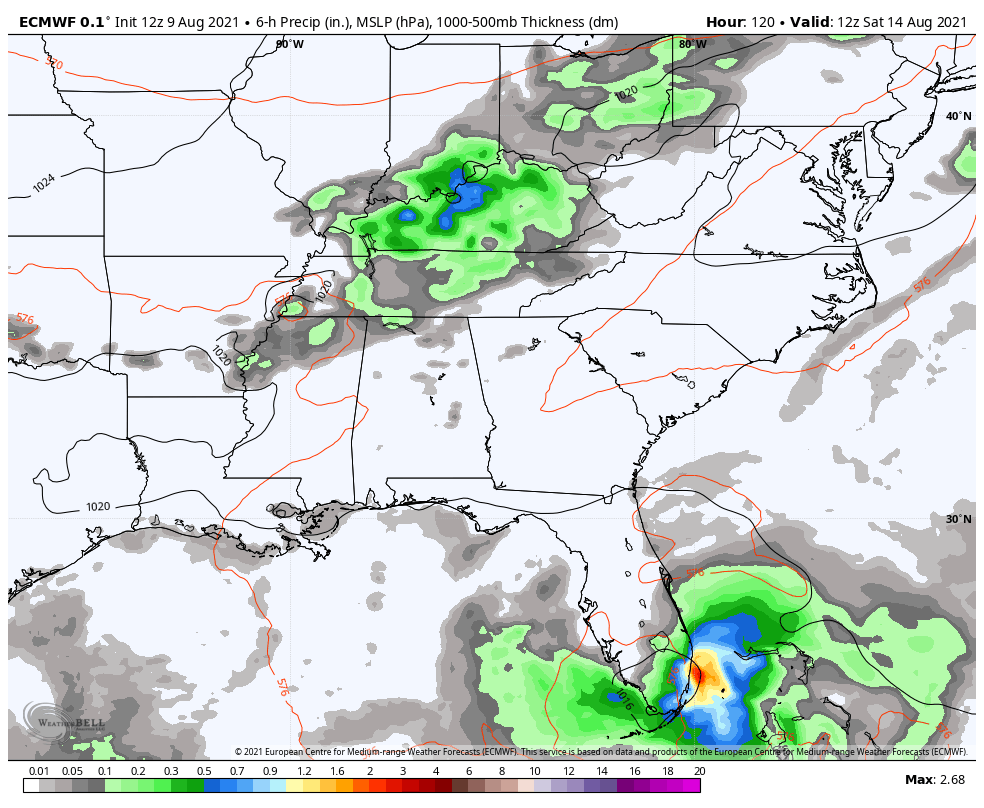
That’s certainly something to keep a close eye on in the coming days.
As always, I have you set to track the rounds of storms rolling through the region today…

Current watches

Possible Watch Areas

Make it a terrific Tuesday and take care.

Several tornadoes touched down Monday evening in the far West and NW Suburbs of Chicago, some of which caused damage. Here is the link for the summary of the tornadoes from the NWS: http://weather.gov/lot/2021/aug09
Here is the link for the news reports about the tornadoes from a Chicago TV station, including a couple of amazing videos and photos showing the tornadoes: http://abc7chicago.com/chicago-weather-severe-storm-forecast-radar/10940826/
Here in the SW suburbs where I live, in Will County, not even a drop of rain! There was a Tornado Warning issued around 10:30 PM for Eastern Will County near the Indiana border, but that’s about 40 miles away from my location.
Thanks Mike for sharing, I’m sorry the couple in the first video lost their home in one of the tornadoes. It’s very sad, but no one lost their life. Hoping they will return to normal soon.
Second video as the reporter said “very impressive” showing one of the tornadoes in action thanks to storm chaser’s work.
Here in central Kentucky it feels more like a day in June with very uncomfortable dew points. Yesterday, late afternoon I recorded 1.34 inches of rain in my backyard.
Looking forward to drier (lower dew points) this coming weekend.
I recorded .83 of much needed rain on the south east side of Lexington yesterday.
I thought I might receive some rain this morning.
But it appears that the line of rain west of the metro is weakening or dying.
I will keep my fingers cross.
I hit the jackpot. The small alone rain cell that moved thru. the county went over my house.
A 5 minute heavy downpour.
Exactly the same thing happened here !
Today is the one-year anniversary of the August 10th, 2020 derecho, which swept across much of the Midwest. It resulted in an incredible $11.5 billion in damages, making it the costliest known thunderstorm event in modern U.S. history. Power was out at my location for over 32 hours.
http://weather.gov/lot/2020aug10
Dew points are extremely oppressive here in the Chicago Metro Area this afternoon, with many areas having a dew point of at least 80!
With the atmosphere so moist and unstable and primed to explode, parts of the area are under an Enhanced Risk of severe weather for later this afternoon and evening, with the rest of the area under a Slight Risk.
I’ve never had experience a derecho, but I imagine it would be like a hurricane ?
The NWS out of Chicago sure has great information on storm events.
Dew point here in Maple, Kentucky is 77.0 degrees. I can hardly catch my breath. I believe this is the highest it’s been (dew point) in several years.
Here we go again… Severe Thunderstorm Warnings are being issued as a formidable line of storms moves in from the West towards the Chicago area.
Stay safe Mike !