Good Wednesday to one and all. It’s another day of steamy temps and scattered storms across the bluegrass state as we get set to track some changes by the weekend. That’s when a strong cold front rolls in here and slows down at the same time a tropical system heads toward the eastern Gulf. That system has a shot to impact our weather by early next week.
Temps today range from the middle 80s to middle 90s, but the humidity will make it feel MUCH higher than that. Triple digit head index numbers will show up in the west.
The threat for a few clusters of storms will also be with us, especially in central and eastern Kentucky. Storms are likely rolling from northwest to southeast and may contain gusty winds and torrential rains. Here are your radars to follow along…

Storms aren’t as prominent on Thursday and that allows for a very toasty day for the entire state. With humidity levels way up there, it will be a day to slow down if you have to be outside for an extended period of time.
Those toasty temps carry us into Friday as winds gust up ahead of a cold front. That front drops in by Friday night and should bring strong storms with it into early Saturday…
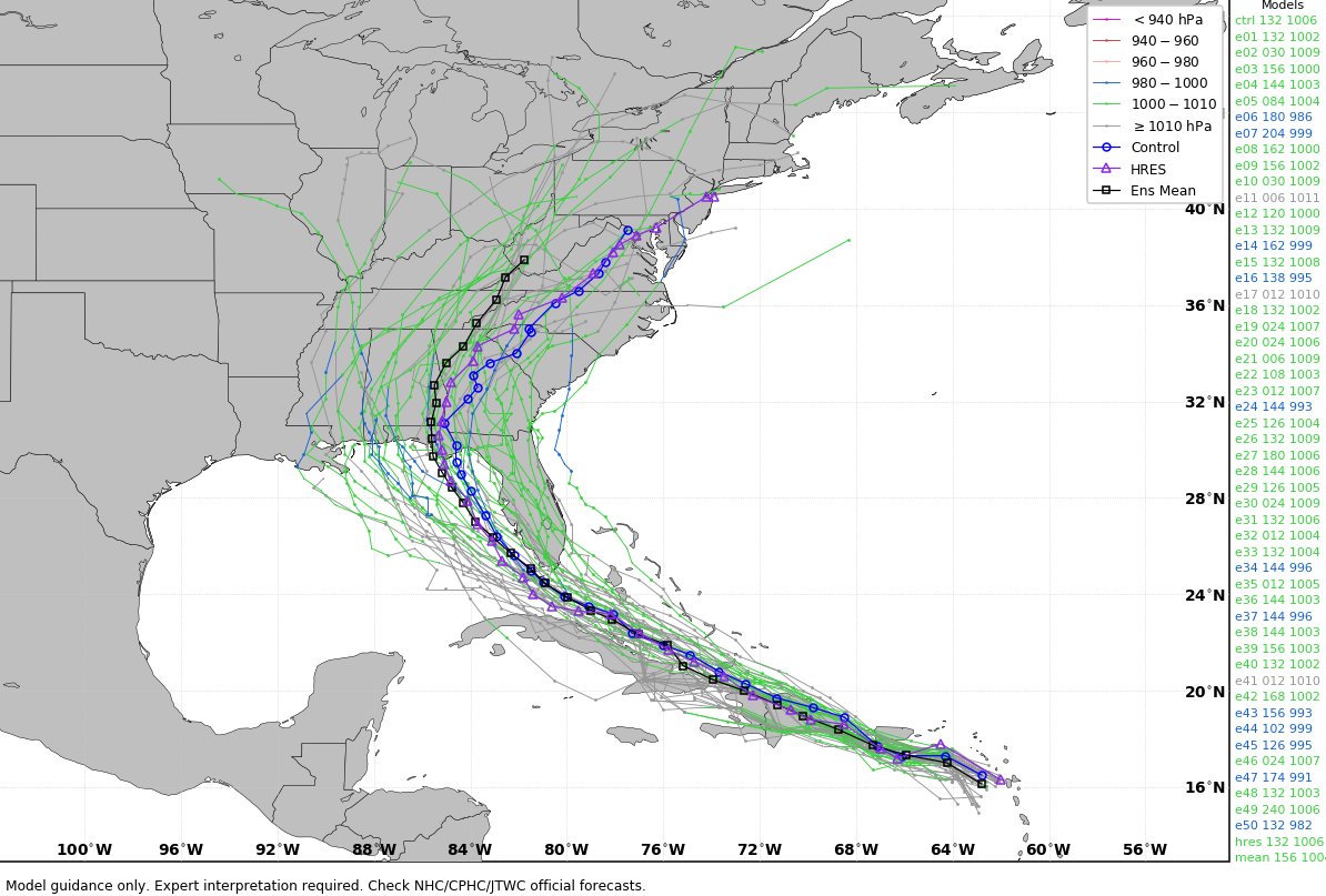
That front slows down and keeps storm chances going through the weekend. It’s slowing down because of what will be moving into the eastern Gulf of Mexico by the weekend. Our tropical system will continue to increase during this time. Here’s the latest information and track forecast from the National Hurricane Center…

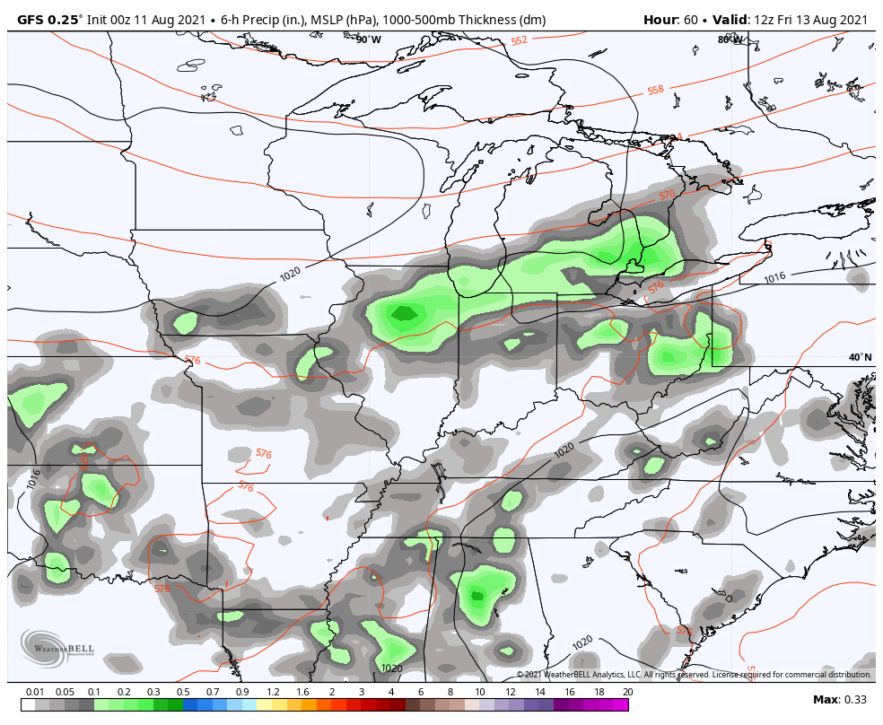
The spaghetti plots from the various ensembles look like this…
EURO
GFS
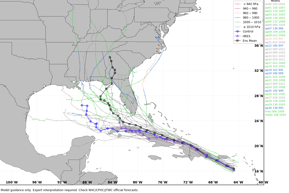
Deep tropical moisture is likely to stream well out ahead of Fred and this can produce showers and storms around here early next week. That kind of setup can lead to torrential rainfall with or without a direct impact from the storm.
The inland track of this storm won’t be known for several days and it’s something that’s certainly worth keeping a close eye on.
Have a great day and take care.

It was a steam bath today.
I mowed my grass around 8:30 p
Thursday looks brutal .
The temperature has hit 94 here Monday and Tuesday and likely be the same untill the fro nd comes through.. The hiigh humidity is the killer as always. Theses hot and steamy days can be and sign of some rough winter ahead.
Terrible high dew points here in Maple, Kentucky. Reminds me of the heat we had years ago when I had my plant nursery in Southwest Indiana.
The Tropics will determine what weather we will have this Fall and Winter. Almost always does. In my opinion one who professionally gives out these forecast can use 2020 as an analog year, just saying.
Any recommendations from you guys on a personal weather station? It would also be nice to contribute data to the weather community (e.g., Weather Underground).
https://www.wunderground.com/pws/buying-guide
Hope the above helps you in your quest.
8:00am near Bowling Green, and the Heat Index is already 92°. Yesterday’s high was 96°, and the Heat Index topped out at 114.2°. It’s likely that we’ll exceed that mark today and tomorrow. On Monday we received our first measurable precipitation since July 18th, as a gully washer put down a quick 0.5″. It’s been a year of extremes, which I fear is our #NewNormal…
Here is a summary of the severe thunderstorms that produced widespread tree damage over portions of Northern IL and the Chicago area early Tuesday evening. http://weather,gov/lot/2021aug10
It’s ironic that this came on the one-year anniversary of the August 10, 2020 derecho event.
My bad for the typo, here’s the proper link: http://weather.gov/lot/2021aug10
The Chicago Metro Area is under an Enhanced Risk for severe weather this evening, as there’s significant wind shear in the atmosphere and a greater likelihood of tornadoes as a result. Parts of Wisconsin are really getting hit hard now, as there’s a Tornado Watch for much of that state.