Good Thursday, everyone. It’s another hot and humid day across Kentucky as we get set to fire up some additional rounds of storms. The storms dropping in here ahead of a cold front may go severe at some point before some better feeling air moves in for the weekend. That’s when indirect impacts from Fred will be felt around here.
Let’s kick this summer party off with temps soaring across the state. Highs reach the 90s for many with 100+ heat indices showing up, with the western half of the state getting in on the worst of this. A few thunderstorms will try to go up, but much of the action will be north of us closer to the cold front. Still, the Storm Prediction Center has the areas of the north in a low-end severe weather risk today…

As the front gets closer on Friday, a line of strong to severe storms looks to form along and ahead of it. This line should drop into Kentucky late in the day into the evening hours and we may have to deal with some severe storms. The Storm Prediction Center has much of the area in the severe weather risk…

Much better air comes in behind the front for the weekend, but we will still see a leftover shower or storm on Saturday. Sunday looks mostly dry except for a storm threat in the south and southeast.
From here, much of the forecast hinges upon the track of Fred. Here’s the latest info and forecast track from the National Hurricane Center…

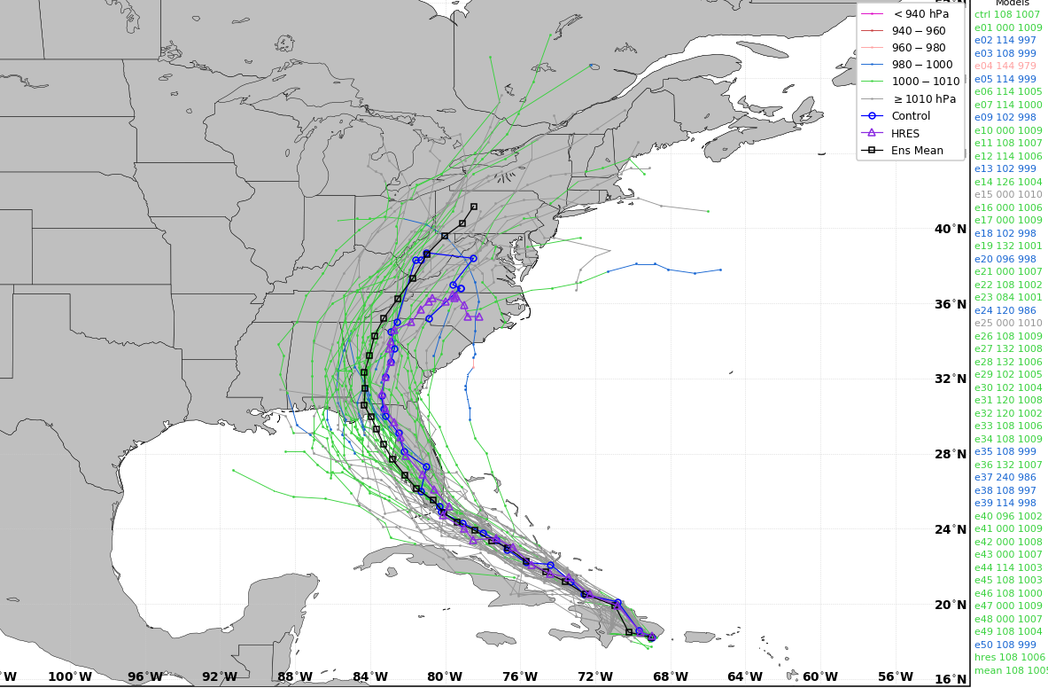
The EUROPEAN Ensembles have several members that bring the remnant low across eastern Kentucky…
This is something showing up on the new Canadian Model…
The GFS has a farther east track, but shows plenty of tropical moisture streaming in here ahead of Fred…
There’s another system lurking behind Fred and that has a chance to impact the southeast in the next week and change…

I leave you with your Thursday thunder trackers…

Current watches

Possible Watch Areas

Make it a great day and take care.

I have been mowing my grass around 8:30p.
Front yard Tuesday& backyard Wednesday.
It was still a major sweat storm..
Test
The second day in a roll that my comments didn’t travel through the Cybersphere.
That’s strange that would happen. I’m usually the one that has a problem connecting on. Looks like you have fixed the problem. Hopefully, it will stay that way.
Looks like the projected path of a reformed Tropical Storm Fred is holding.
Fred is following the same path as Tropical Storm Elsa. I don’t know how many times back to back Tropical cyclones followed the same path. Could be interesting the next few days.
I don’t like Tropical weather in Kentucky. LOL