Good Saturday to one and all. It’s all eyes on Hurricane Ida spinning into the Gulf of Mexico today. This storm will strengthen as it heads toward a Sunday landfall in Louisiana and the remnants of this will impact Kentucky early in the new week. This brings a heavy rain threat our way.
Before we get into the Ida part of the program, it’s another steamy day out there with storms going up. Here are your radars…

The steam and storm threat continues into Sunday before things get interesting to close out August.
Hurricane Ida is now in the Gulf of Mexico and continues to rapidly strengthen as it works to the northwest…

Ida will become a major hurricane before hitting Louisiana late Sunday. From there, this storm works toward the north then northeast Monday and Tuesday. By Wednesday, what’s left of the center of circulation should be moving into Kentucky. Here’s the latest info and track forecast from the National Hurricane Center…

With the leftovers passing right on top of the region, heavy rainfall and gusty winds will be likely. We may have some gusts of 30mph or greater with this setup, but it’s the flood threat that has to be watched. Here’s my early look at where the heaviest rains may set up…
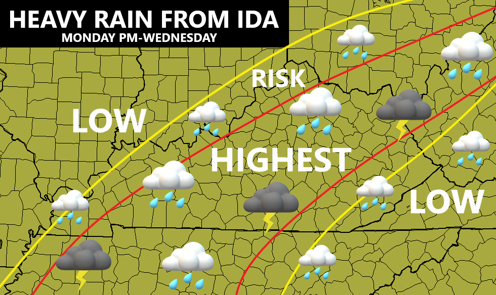
That map may change some as the inland track of Ida becomes more set in stone, but I don’t expect a drastic change at this point.
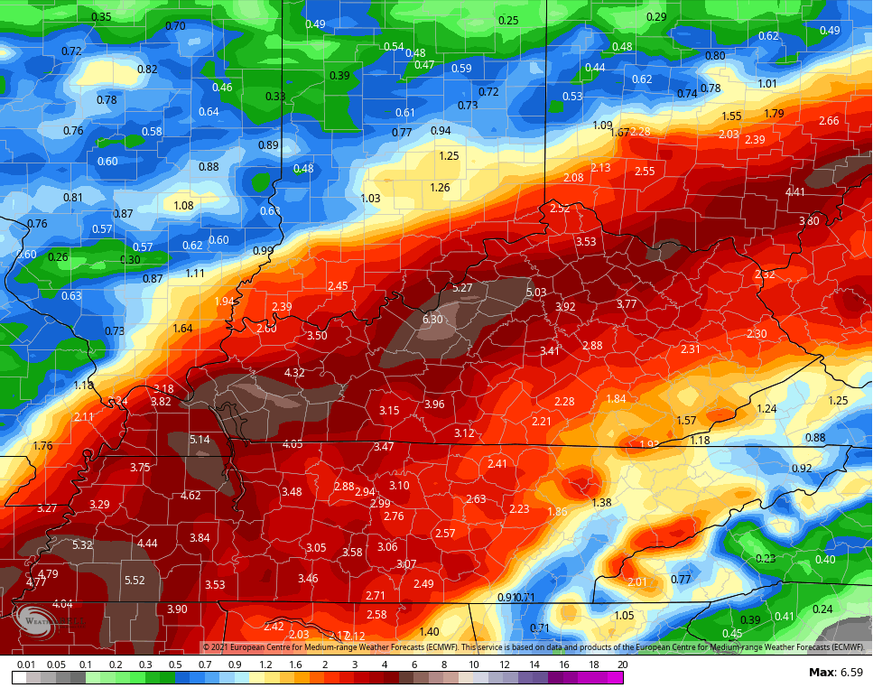
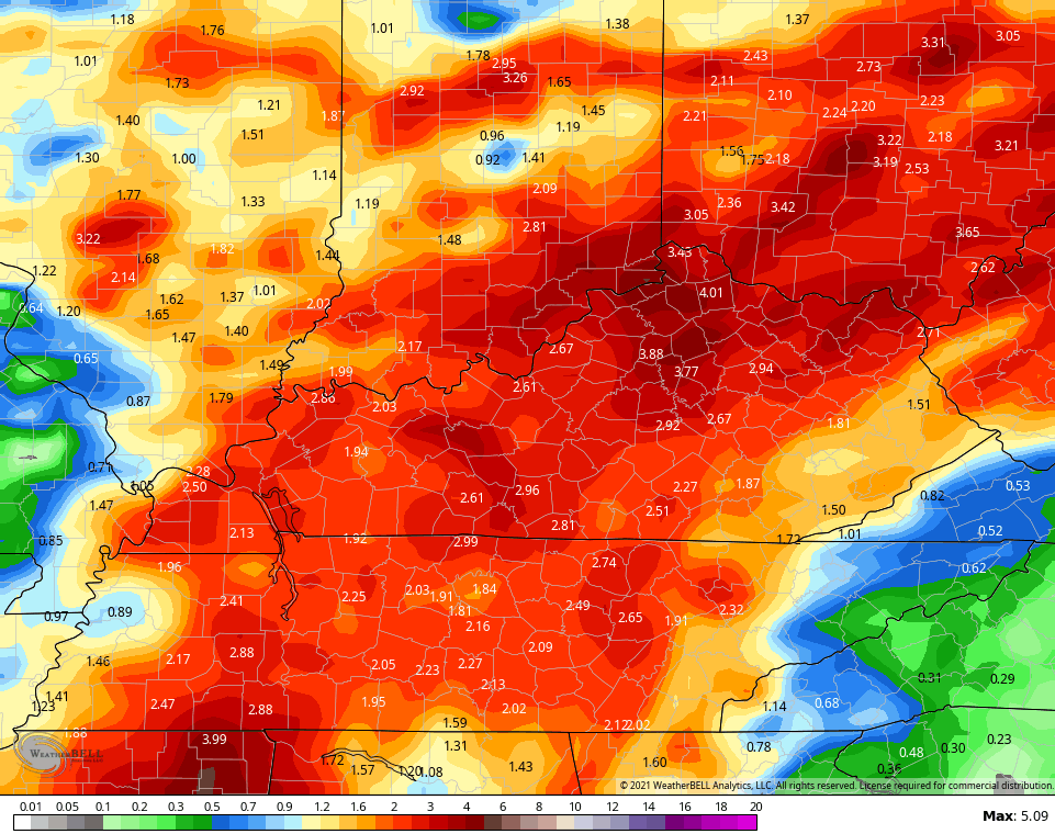
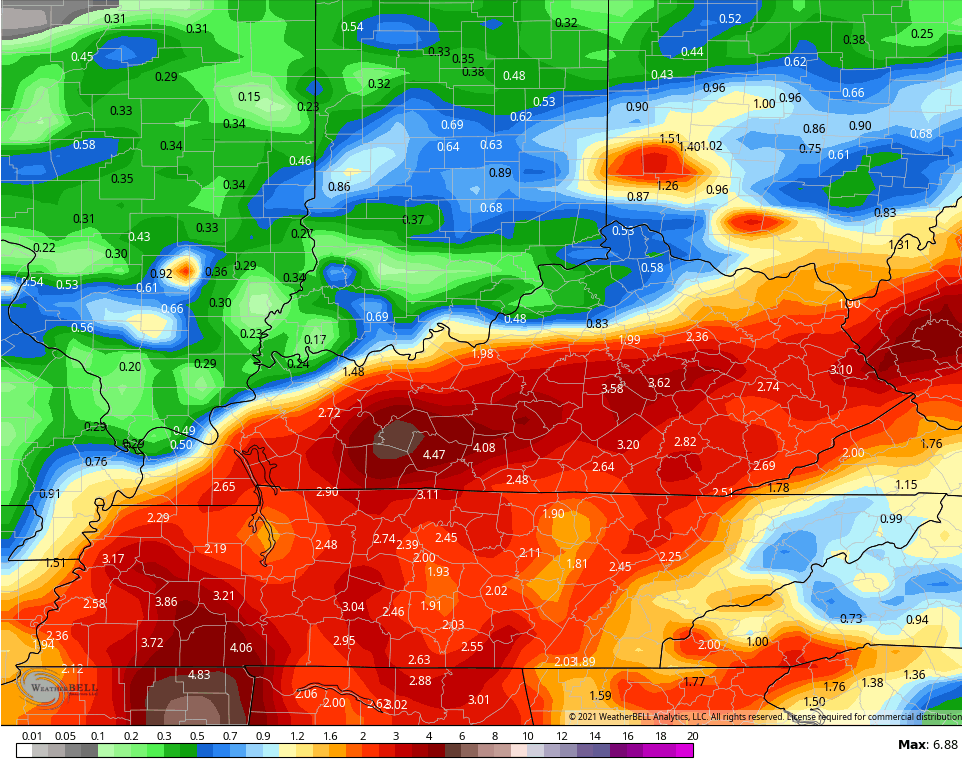
Here are some of the rainfall numbers from the computer models…
EURO
GFS
CANADIAN
ICON
![]()
![]()
Here are a few things to keep in mind:
- The heaviest rains may fall along and just north/west of the track of the center of circulation.
- I expect a general 1″-4″ of rain from late Monday through Wednesday, but locally higher amounts will be possible.
- This could be enough to create some flooding issues in our region.
- Wind gusts of 30mph or greater will also be possible as what’s left of Ida moves across the area.
I will have another update or two later today, so check back.
Have a great Saturday and take care.

The Euro shows the heaviest amount of rain falling in my area.
We could use some more rain here, but we are still good with soil moisture.
Ida is likely to become a monster in the next few days. A lot of residence along the Gulf have already evacuated after remembering Hurricane Katrina a few years ago.
After passage of circulation we may have a few days of pleasant temperatures before the tropical weather returns.
We could still use some rain in my county of Taylor, but we are still good on soil moisture for the soybean crops. Corn crop is excellent and ready to dry a bit before harvest time.
After Tropical Depression Ida has past and faded into the future we may actually have a few days of pleasant late Summer weather before heat and humidity return.